On Scotland Route A894, 2.4 kilometers south of the Kylesku Bridge, on the left when traveling south.
A geological sandwich
Sreath air muin sreath
For many people, this is one of the grandest views in Britain — and for geologists it's also one of the most exciting! Look at the scene across the loch and you can see two lines running . . . — — Map (db m127934) HM
On Route A838, 25.3 kilometers south of the village of Durness, on the left when traveling south.
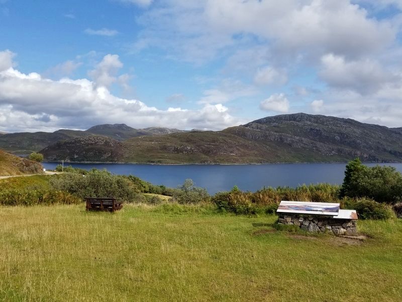
A moving story
Siubhal nan clach
The boulders you see perched on top of the low hill across the road weren't always there. The huge blocks of rock once lay many miles to the southeast. So how did they get here?
Chithear ulbhagan mòra . . . — — Map (db m127906) HM
On Scotland Route A837, 1.3 kilometers south of Scotland Route A894, on the right when traveling south.
Ardvreck Castle
Seat of the MacLeods of Assynt
An old song makes history alive again,
as a rickle of stones perplex the dark theatre
of the mind with a shouting crowd and,
in the middle, MacLeod of Assynt
and his greater prisoner . . . — — Map (db m127936) HM
On Route A837, 2.1 kilometers south of Route A894, on the right when traveling south.
Calda House
Conjectural Reconstruction c.1730
Calda is still known locally as the White House and, with its white walls and window and door surrounds of imported dressed sandstone, it must have looked very splendid indeed. It had two . . . — — Map (db m127938) HM
On Scotland Route A838, 3.2 kilometers west of Scotland Route A836 when traveling west.
Causeway Tongue House, on the north east side of the Kyle, was rebuilt in 1678 — after being burned by Cromwell's troops — and further added to in 1750. Once the seat of the Mackay chiefs, it has belonged to the Sutherland family . . . — — Map (db m127826) HM
On Scotland Route A838, 43.4 kilometers west of Scotland Route A836, on the left when traveling west.
Ceannabeinne
Ceann na Bienne
Ceannabeinne is the township at the end of a chain of hills stretching north from Cranstackie (801 m). The area divides Loch Eriboll from the Kyle of Durness. The pink coloured rock is Lewisian gneiss, commonly found . . . — — Map (db m127828) HM
On Scotland Route A838, 45.1 kilometers west of Scotland Route A836, on the right when traveling west.
Ceannabeinne Township Trail
The Highland Township
In the Eighteenth century Ceannabeinne was typical of a farming community in the Highlands. The farm was rented by a Tacksman from Lord Reay, Chief of Clan MacKay. In turn he sub-let the . . . — — Map (db m127829) HM
On Scotland Route A838, 45.1 kilometers west of Scotland Route A836, on the right when traveling west.
Ceannabeinne Township Trail
Houses and Homes – Life begins to get better
Of the 14 houses recorded here in 1841, little remains. However, in front of this sign you should be able to make out the rectangular foundation of a house, . . . — — Map (db m127830) HM
On Scotland Route A837, 1.3 kilometers south of Scotland Route A894, on the right when traveling south.
Chambered Cairn
Dating to before 2000BC, by far the earliest indication of human occupation in this area is a burial cairn on a knoll above Ardvreck. It was excavated in 1925 and a massive slab lining one side of the chamber can still be seen in . . . — — Map (db m127937) HM
On Scotland Route A838 at where A838 turns left toward Rhiconich, on the left when traveling west on State Route A838.
Durness
This stone feature, built in 1886, was originally located at the road junction and housed a clock. It was moved to this location in 1993 when the Village Square was upgraded. George Whyte of Sangomore, the local stonemason, was reputedly . . . — — Map (db m127832) HM
On Scotland Route A838 at where A838 turns left toward Rhiconich, on the left when traveling west on State Route A838.
Erected by the
People of Durness
to the
Glory of God
And in Sorrowful
Memory of Their
Noble Dead Who
Fell in the Great
War of 1914 1919.
And also in
Memory of Those
Who Gave Their Lives
1939—1945.
Siol nan Sonn’s . . . — — Map (db m127831) WM
On Scotland Route A837, 5 kilometers south of Scotland Route A894, on the right when traveling south.
Glacier detectives
Sruthan nam fianais
Icy evidence
Glaciers leave a trail of evidence showing where they've been. But it's not always a simple piece of detective work to find out exactly what happened in the past.
Dileab na deighe . . . — — Map (db m127939) HM
On Scotland Route A835, 4.8 kilometers south of Scotland Route A837, on the right when traveling south.
Green and pleasant land
Cluaintean glas is sìtheil
As you arrived in Elphin, did you notice that the grass looks greener here?
This is because the rock under the soil is limestone, which makes the ground more fertile than the . . . — — Map (db m127968) HM
On Route A838 at Unnamed Road to Keoldale, on the right when traveling south on Route A838.
Keoldale Green
Rubha an Tigh Shaille
Rubha an Tigh Shaille is Gaelic for 'Point of the Salt House' more commonly known today as 'Keoldale Green. The land here is an oasis of green in a barren wilderness, the weathering of the ancient Cambrian . . . — — Map (db m127903) HM
On Scotland Route A838, 3.2 kilometers west of Scotland Route A836, on the left when traveling west.
County Council of Sutherland
Kyle of Tongue Crossing
This crossing was opened on Friday 3rd September 1971
by
Councillor Mrs C.B. Mackay Tongue
D. McBain, Convenor — Donald Macleod, Chairman — J.B. Rodger, County Clerk
Sir . . . — — Map (db m127827) HM
On Scotland Route A894 at the Kylesku Bridge, on the right when traveling south on State Route A894.
Kylesku Bridge
Opened by
Her Majesty The Queen
8th August, 1984
The bridge replaces the ferry service which has existed since the early nineteenth century. The bridge was built for the Highland Regional Council and partly financed by the . . . — — Map (db m127908) HM
On Scotland Route A838, 13.8 kilometers south of the village of Durness, on the right when traveling south.
1883
As A Mark
Of Gratitude And Respect
To The Inhabitants Of
Durness And Eddrachillis
For Their Hospitality,
While Projecting This
Road, This Inscription Is
Placed Over This Well By
Their Humble Servant
Peter Lawson . . . — — Map (db m127905) HM
On Scotland Route A838 at Unnamed Road to Keoldale, on the right when traveling south on State Route A838.
Stories in sand
Gainmheach Angelo aithris
During the Ice Age, great glaciers and ice sheets gouged out the river valleys and scoured the mountains here. Today, wind and waves help shape this sandy landscape.
Ri Linn na Deighe, rinn . . . — — Map (db m127904) HM
On Route A894 at the Kylesku Bridge, on the right when traveling south on Route A894.
This Cairn Was Erected To
Commemorate the 50th Anniversary of
The XIIth Submarine Flotilla
10th April 1993
The Security of These Top Secret Operations Was
Guarded by the Local People of This District Who
Knew So Much and Talked So Little . . . — — Map (db m127907) HM