On High Street (Ohio Route 104), on the right when traveling north.
Situated on land owned by Thomas Worthington, Camp Bull was a stockade constructed in this vicinity to confine British prisoners of war during the War of 1812. When Commodore Oliver Hazard Perry defeated the British fleet on Lake Erie on September . . . — — Map (db m14631) HM
On Riverside Drive (U.S. 33), on the right when traveling north.
A network of Native American trails, usually following waterways, traversed Ohio and often determined the routes of military roads and improved highways. U.S. Route 33 follows the route of the Scioto Trail from the confluence of the Scioto and . . . — — Map (db m17415) HM
On Marion Street (Ohio Route 423) at Main Street, on the right when traveling north on Marion Street.
Side A: The first road through Marion County followed the Scioto Trail of the Native Americans. This 120-foot wide strip through Wyandot territory led from Lower Sandusky (Fremont) to the Greenville Treaty Line. A confederation of Ohio tribes . . . — — Map (db m22923) HM
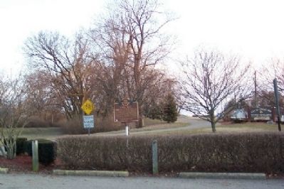
On Delaware Avenue (Ohio Route 423) at Main Street, on the right when traveling north on Delaware Avenue.
Jacob Foos, while surveying the Military Road north from Fort Morrow to Fremont during the War of 1812, dug a well at this site. General William H. Harrison and his troops, on their way to Lake Erie, camped here and drank from the well. This area . . . — — Map (db m29048) HM
On S. Sandusky Avenue (Ohio Route 53) at E. Wyandot Avenue (U.S. 30), on the right when traveling north on S. Sandusky Avenue. Reported permanently removed.
On E. Wyandot Avenue (U.S. 30) close to 4th Street, on the left when traveling east.
Fort Ferree
built by Gen. Harrison's Army, 1812.
Overland Inn
1814 until 1846, on site Elks Lodge.
Indian Spring
used by Indians 1730 to 1843.
Col. Crawford's Army drank at Spring June 4, 1782.
Charles Dickens stopped at Inn and Spring, . . . — — Map (db m114533) HM
On Frost Parkway at Adams Street, on the right when traveling east on Frost Parkway.
In July 1813 a detachment of soldiers under Lt. Col. James V. Ball built a supply fort here along the military road that ran along the west bank of the Sandusky River. Ball chose this site for its large spring of cold water, which he enclosed within . . . — — Map (db m17977) HM
On Fremont-Tiffin Road (Ohio Route 53) at Township Road 1020 on Fremont-Tiffin Road.
In the 1820s a general store and a grist mill were established near this site, where the famous Scioto-Sandusky Indian Trail neared the Sandusky River. The settlement was first known as McNutt's, later as Swope's Corners. The village of Fort Seneca . . . — — Map (db m18126) HM
On Fremont-Tiffin Road (Ohio Route 53) at Township Road 1020 on Fremont-Tiffin Road.
Ohio
Revolutionary
Memorial
Trail
Text on South Side :
Harrison • Shelby
Marches • 1813
- - - - -
12
Miles to
Brady's
Island
Text on North Side :
Harrison • Shelby
Marches . . . — — Map (db m20577) HM
On County Road 51 at Harrison Street, on the right when traveling north on County Road 51.
This tablet marks the site of Fort Seneca built in July 1813 by Major General William Henry Harrison during the War of 1812 with Great Britain; and also marks the military road known as the "Harrison Trail" blazed through the forest in 1812 by . . . — — Map (db m17997) HM
On South River Road, on the right when traveling north.
Near this spot an old footpath bypassed the lower rapids of the Sandusky River from midtown Fremont south to Tindall Bridge. Along this trail Indian portaged their canoes around swift rapids. This was the Old Sandusky-Scioto Trail, an ancient . . . — — Map (db m18189) HM
On Buckland Avenue at Tucker Road, on the right when traveling north on Buckland Avenue.
Major Ball’s Squadron 2nd Light Dragoons U.S. Army while escorting Col. Wells 17th U.S. Infantry from Major General Harrison’s headquarters at Fort Seneca to relieve Major Croghan of the command of Fort Stephenson for alleged insubordination in . . . — — Map (db m241033) HM
On Buckland Ave. at Cleveland Ave., on the left when traveling north on Buckland Ave..
Roger's Colonial Rangers against the French, 1760.
Bradstreet's British army against Pontiac, 1764.
Butler's British Rangers against Crawford, 1782.
Proctor's British army against Ft. Stephenson, 1813.
Called, after the American invasion of . . . — — Map (db m18209) HM
On Garrison St. at High on Garrison St.. Reported missing.
Lt. Colonel Wm. C. Shortt, Lt. J.G. Gordon, 1 sergeant, 1 drummer, and 21 rank and file of the 41st Regiment, British regulars, who died in the assault on Fort Stephenson, August 2, 1813, and the succeeding amity between the contending nations. — — Map (db m18291) HM WM
On Croghan Street at High Street, on the right when traveling east on Croghan Street.
Victoriously defended by Major George Croghan.
Battle of Fort Stephenson, August 2, 1813.
Built on this spot 1812-1813 and named for Col. Mills Stephenson, one of its builders.
Major George Croghan, age 21, took command in July 1813. . . . — — Map (db m18093) HM
On Court Street east of Justice Street, on the right when traveling west.
British cannon from Commodore Barclay's fleet bombarded Major Croghan in Fort Stephenson August 1 and 2, 1813. General Proctor attempted to capture the fort by assault with his Wellington veterans assisted by Indians under Tecumseh. Major Croghan . . . — — Map (db m18285) HM
On North Front Street north of West State Street (State Route 20).
The Junquindundeh of the Indians, and the Lower Sandusky of the Revolutionary War and War of 1812.
—
An old neutral town of the Eries used as a refuge on the destruction of the Huron commonwealth by the Iroquois in 1650.
—
Westernmost . . . — — Map (db m218957) HM
On East Perry Street (State Road 163) at Fulton Street, on the right when traveling east on East Perry Street.
Captain Barclay's British Fleet transporting General Proctor's British army sailed up the Sandusky River to make their assault on Fort Stephenson August 1st and 2nd 1813 of which General Sherman wrote:
"The defense of Fort Stephenson by Croghan . . . — — Map (db m165786) HM
On East Perry Street (State Road 163) at Fulton Street, on the right when traveling west on East Perry Street.
From Fort Seneca to Detroit and the invasion of Canada as noted in Captain R.B. McAfee's history 1816.
Major General Harrison on receiving word of Commodore Perry's victory proceeded to Fort Stephenson and "issued his orders for the movement of . . . — — Map (db m18252) HM