The Pratt Army Air Field one mile historical walk starts by this sign and circles the B-29 All Veterans Memorial and the B-29 Museum. The first B-29 Superfortress bombers manufactured by Boeing Wichita flew into Pratt Army Air Field (PAAF) . . . — — Map (db m230000) HM
The Pratt Army Air Field is an important site that shares the birthplace of the B-29 Program, a program that defeated Japan in three years nine months and ushered in atomic warfare. Site preparation grading started in October 1942; the first . . . — — Map (db m229898) HM
In early 1941, before the Pearl Harbor attack, the U.S. Military began plans to expand land and air strength due to brewing world tensions. In August 1942, the War Department authorized money for a military installation to be built at Pratt KS USA. . . . — — Map (db m229988) HM
PAAF1941 US Military Begins Plans to Expand Land and Air Strength AUG-42 War Department Authorizes Money for Military Installation at Pratt KS USA SEP-42 Construction of Pratt Army Air Field Begins FEB-43 PAAF Designated as a Full . . . — — Map (db m229963) HM
The PAAF Celestial Navigation and Bombing Trainer was housed in a concrete "grain silo". Inside is a fuselage section, with the Navigator in the foreground taking a sighting of a star with a celestial sextant instrument to determine the aircraft's . . . — — Map (db m230084) HM
The Link Trainer Building was located in this area on the north side of PAAF, and housed several Link Aviation Flight Simulation Trainers. These simulators became famous during World War II, when they were used as a key pilot training aid by almost . . . — — Map (db m229996) HM
The 23rd Airways Communication Squadron manned the PAAF Control Tower located east of here on the runway apron in-line with the hangers. They were a detachment of the 106th Army Airways Communication System stationed in Kansas City, Missouri. When . . . — — Map (db m229997) HM
The Base Operations building located directly behind this sign on the runway apron was one of four identical buildings between the hangers. They served as squadron headquarters, housing squadron administration and training. Pictured is an outdoor . . . — — Map (db m229998) HM
In many ways, the Pratt Army Air Field was like a small city or town. This earned it the nickname — "PAAF-Ville". It had facilities to meet people's needs like most cities would have. On the left — the first building is Finance, then the Post . . . — — Map (db m229999) HM
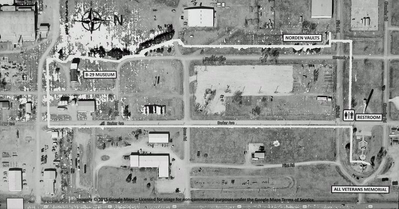
The concrete vaults in front of you were used to secure the TOP SECRET Norden Bombsights used to train the bombardiers in bomb sight operation and maintenance. The Norden was a computerized bomb sight that was an important part of World War II . . . — — Map (db m230076) HM
The Parachute Building is listed as a National Historical site since 22 April 2009. Restoration on the B-29 Museum is funded by the Kansas Historical Society. Original construction started in November 1942. The building was completed by May 1943 . . . — — Map (db m230090) HM
The Sub-Depot Hanger (Hanger #1), located just south-west of this sign, is one of the original five hangers built at the air base, and is one of the few original PAAF buildings still standing. It is currently being leased to a local machine shop by . . . — — Map (db m230101) HM
Victory Gardens, also called "War Gardens" or "Food Gardens for Defense", were vegetable, fruit, and herb gardens planted at private residences and public parks in the United States, United Kingdom, Canada, Australia and Germany during World . . . — — Map (db m230187) HM
History has recorded the Battle of Kansas as an all-out effort by the US Army Air Forces to get a combat-ready fleet of B-29s overseas to bomb Japan and destroy the factories that fueled its war effort. The battle to renovate the B-29s was fought . . . — — Map (db m230188) HM