On Old U.S. 61, 0.3 miles north of Rinaudo Drive, on the left when traveling north.
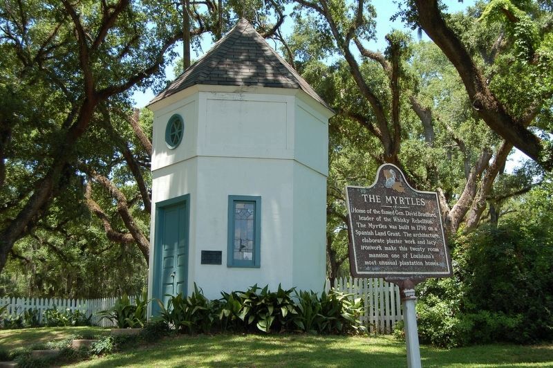
Home of the famed Gen. David Bradford, leader of the Whisky Rebellion. The Myrtles was built in 1796 on a Spanish Land Grant. The architecture, elaborate plaster work and lacy ironwork make this twenty room mansion one of Louisiana's most unusual . . . — — Map (db m85647) HM
Fort Cumberland was garrisoned from 1754 to 1765. During this period, there was bickering between Maryland and Virginia as to how the fort should be maintained and whose control it was under.
In early 1756, Colonel Washington favored a small . . . — — Map (db m17708) HM
On Canal Street, 0.1 miles north of West Harrison Street, on the left when traveling north.
About this sign
The outline drawing above represents the heritage-themed mural to your right. The mural is organized chronologically into sections. Each section is described here, with accompanying historic images..
. . . — — Map (db m140048) HM
On Prospect Square at Washington Street, on the left when traveling south on Prospect Square.
Horatio Sharpe Lived: 1718-1790. Here as Governor of Maryland and the commander of the fort. Fort Frederick was built by his direction. Governor: 1753-1769. Sharpsburg, Md., was named in his honor. Daniel Boone Lived: 1734-1820. Here as a . . . — — Map (db m17681) HM
On Greene Street at Bridge Street on Greene Street.
Our founding father spent much time in this vicinity when a young man as surveyor, ambassador, aide-de-camp to General Braddock, and commander of Virginia military forces. This cabin served as his headquarters during part of this time.
Young . . . — — Map (db m167057) HM
On Washington Street at Prospect Square, on the left when traveling west on Washington Street.
On this site originally stood the Headquarters of George Washington, since removed to Riverside Park. He was entertained at David Lynn's house (which later occupied this site) when he came here in 1794 to review the troops during the Whisky . . . — — Map (db m155434) HM
On Washington Street at Prospect Square, on the left when traveling west on Washington Street.
Center Plaque
On October 16, 1794, President George Washington arrived in Cumberland to review about 5,000 troops of the Maryland and Virginia militia gathered here during th Whiskey Rebellion. A few days later, this militia army assembled upon . . . — — Map (db m17456) HM
On Washington Street at Prospect Square, on the right when traveling west on Washington Street.
The fort proper was the bastioned work at the west end of the fort. It was to your left (primarily on the site of the Church of Christ Scientist). Besides the four bastions (b) and the joining walls, there were four buildings for provisions (6), two . . . — — Map (db m167356) HM
On Bellona Avenue at Malvern Avenue, on the left when traveling south on Bellona Avenue.
He commanded “Baltimore Light Dragoons” during the Revolution, attaining rank of Captain. He took active part in suppression of Whiskey Rebellion in 1794, and that year purchased “Bosley’s Adventure,” a 350 acre farm west of . . . — — Map (db m2283) HM
On West Memorial Boulevard just west of South Potomac Street (Maryland Route 65), on the right when traveling west.
1791
The town's first fire company (United) is formed. Residents are required to own a leather bucket for fire fighting.
1791
On December 27, Elizabeth Town is incorporated by the Maryland General Assembly. The legislature . . . — — Map (db m146006) HM
On Biglerville Road (Pennsylvania Route 34) at Goldenville Road, on the right when traveling north on Biglerville Road.
George Washington returning from expedition to quell Whiskey Insurrection spent the night ¼ mile west of here at Russell’s Tavern — — Map (db m67676) HM
On Biglerville Road (Pennsylvania Route 34) at Goldenville Road, on the left when traveling north on Biglerville Road.
The original building in which George Washington lodged in October, 1794, while engaged in quelling the Whiskey Rebellion is standing just west within view of this point. — — Map (db m63676) HM
On Library Street / Jones Avenue south of Bell Avenue, on the right when traveling north.
Known as the high tide of the Whiskey Rebellion, the rendezvous of militias from Pennsylvania's four western counties took place here, August 1-2, 1794. This was the largest armed resistance to the national government between the Revolutionary and . . . — — Map (db m59178) HM
On Kane Boulevard, 0.3 miles west of Bower Hill Road, on the left when traveling west.
Site of General John Neville's mansion, burned to the ground by insurgents during a major escalation of violence in the Whiskey Rebellion, July 16-17, 1794. General Neville was Inspector of Revenue under President Washington. In the two-day battle, . . . — — Map (db m40393) HM
Irish born, educated in medicine, Irvine practiced in Carlisle till the Revolutionary War. Led a Pennsylvania Regiment in important campaigns. In 1781, chosen by Washington to command western department, headquartered at Fort Pitt. Headed . . . — — Map (db m40232) HM
On Pitt Street (Business U.S. 30) 0 miles west of Richard Street (Pennsylvania Route 220), on the right when traveling west.
Built about 1771. It was the headquarters of George Washington in October, 1794, when he came to Bedford to review troops assembled here to quell Whiskey Rebellion in western part of the State. — — Map (db m14015) HM
On Pitt Street (Business U.S. 30), on the right when traveling west.
“First in war - first in peace, and first in the hearts of his countrymen.”
This tablet marks the building used by President George Washington as his headquarters October 19 and 20, 1794, when he was in Bedford, in charge of the United . . . — — Map (db m14089) HM
On Pitt Street (Business U.S. 30) at Telegraph Road, on the left when traveling west on Pitt Street.
Settled about 1750, known then as Raystown. Site of an early trading post and Fort Bedford, 1758. Base for Forbes, Bouquet expeditions. In 1794 Washington here reviewed forces in Whiskey Rebellion. — — Map (db m13995) HM
On Allegheny Road (Pennsylvania Route 31) 0.1 miles west of Lincoln Highway (U.S. 30), on the right when traveling south.
This inn at the junction of the Forbes and Burd Roads was operated, 1779-1815, by Jean Bonnet and his heirs. In mid-1794, during the Whiskey Rebellion, embattled farmers met here and raised a liberty pole to protest the federal excise tax on . . . — — Map (db m60115) HM
On Penn Street at 5th Street (Business U.S. 222), on the right when traveling west on Penn Street.
Site of Federal Inn, erected about 1754. George Washington, with military escort, was a guest here, October, 1794, when on his way to muster an armed force to suppress the Whiskey Rebellion. — — Map (db m25206) HM
On Hanover Street (Pennsylvania Route 34) at Liberty Avenue, on the right when traveling north on Hanover Street.
Home of Gen. Ephraim Blaine, Commissary General of Revolutionary Army, stood on this site. George Washington was a guest here, Oct. 4-11, 1794, while mustering an armed force to quell Whiskey Rebellion in Western Pennsylvania. — — Map (db m15855) HM
On W. High Street at West Street on W. High Street.
Here George Washington reviewed militia from Pennsylvania and New Jersey, rendezvoused at Carlisle, October 1794, before marching to the western part of State to quell the Whiskey Rebellion — — Map (db m30299) HM
On North 8th Street (U.S. 119) at North 7th Street, on the right when traveling north on North 8th Street.
Nearby was the house of this collector of excise tax on whiskey. In the summer of 1794, after the Whiskey Rebellion had turned violent, his house was burned down by an angry crowd. Wells had spurned previous warnings by excise tax protectors. — — Map (db m41774) HM
Near Galley Street, 0.2 miles east of Navy Street, on the right when traveling east.
The monks of Ireland are credited with having developed the art of whiskey making. It was transported to Colonial America by the Scotch-Irish, who were largely responsible for opening up the Appalachian region to settlement in the late 18th and . . . — — Map (db m206312) HM
On Layton Road east of Knox Street, on the left when traveling east.
For some 200 years after the arrival of the first Europeans, the average settlement had to be self-supporting. Food, clothing and shelter were produced locally. Some of the raw materials used for these essentials required processing before they . . . — — Map (db m206952) HM
A two-story stone house occupied as a tavern by William Morrow stood on this site. George Washington, with staff, lodged here, Oct. 12, 1794, when traveling west to review troops assembled at Bedford to suppress the Whiskey Rebellion. — — Map (db m8101) HM
On Carlisle Street at Baltimore Street (Pennsylvania Highway 16), on the right when traveling north on Carlisle Street.
Here on October 12, 1794, President George Washington is said to have taken breakfast while passing through the area to suppress the "Whiskey Rebellion." This tavern, ca. 1700's, was owned by Robert McCullough and was also known as The Mansion . . . — — Map (db m11615) HM
On Garards Fort Road (Pennsylvania Route 2011) at John Corbley Road, on the left when traveling west on Garards Fort Road.
A noted Baptist minister serving area congregations, Corbley was among some 150 men arrested by federal troops on the “Dreadful Night" of November 13, 1794. A vocal opponent of the excise tax on whiskey, he was the area’s best known participant in . . . — — Map (db m238126) HM
This area was a center of protest during the Whiskey Rebellion. A riot occurred at the Berlin schoolhouse in June 1794. In September, according to local historians, Robert Philson raised a liberty pole at his log store on the square; he advised . . . — — Map (db m21554) HM
On Main Street/Glades Pike (Route 31) at Plank Road, on the left when traveling east on Main Street/Glades Pike.
Leader of North Carolina revolt against the British, he fled under an assumed name in 1771. Somerset's first settler; lived at Coffee Springs farm some years. Became a pamphleteer and active in the Whiskey Rebellion. Died in 1795. — — Map (db m21568) HM
On Mingo Church Road west of Pennsylvania Route 88, on the right when traveling west.
Organized in 1783. This pioneer congregation first worshipped in a 50 ft. square log building (with rough benches for seats) constructed in 1786 on the site of the present manse the first pastor, Doctor Samuel Ralston, was born in Northern . . . — — Map (db m205305) HM
On Mingo Church Road west of Pennsylvania Route 88, on the left when traveling west.
The Whiskey Rebellion was a tax protest beginning in 1791 during the presidency of George Washington. The Mingo Creek Society, also known as the Whiskey Boys, was especially outraged at a federal tax levied on each gallon of whiskey they produced . . . — — Map (db m205334) HM
On South Main Street (Pennsylvania Route 18), on the right when traveling south.
Built in 1788 by David Bradford, leader of the Whiskey Rebellion in 1794. Occupied by him until he fled to Spanish West Florida after the collapse of the Rebellion. — — Map (db m40400) HM
On South Main Street (Pennsylvania Route 18) 0 miles south of Wheeling Street.
In 1791, the National Road Heritage Corridor was the stage for a national crisis that came to be known as the Whiskey Rebellion, a scene of climatic moments in the history of the United States and its newly formed government. Responding to the first . . . — — Map (db m40412) HM
On South Main Street (Pennsylvania Route 18) at Cherry Way, on the right when traveling south on South Main Street.
Formed March 28, 1781 out of Westmoreland County and named for General George Washington. A scene of activity in the Whiskey Rebellion, 1791-1794. The county seat, Washington, was made a borough in 1810; then a city in 1924. On the National Road, . . . — — Map (db m40410) HM
On Carlisle Avenue (Pennsylvania Route 74) at Rockdale Avenue, on the right when traveling east on Carlisle Avenue.
In 1751 en route to the land office in Philadelphia
In 1773 on his return from New York where he had taken his step-son Jack Custis to Kings College, now Columbia University
On July 2, 1791 while president and on a tour of the United . . . — — Map (db m173678) HM
Near Natchez Trace Parkway (at milepost 385.9), 0.2 miles north of Summertown Highway (Tennessee Route 20), on the left when traveling north.
In 1809, renowned explorer Meriwether Lewis traveled up the Old Natchez Trace on his way to Washington, D.C. He stopped here at an inn called Grinder’s Stand, and died during the night.
What is a Compass Rose?
A compass rose is a symbol . . . — — Map (db m84631) HM
On North Main Street (U.S. 220) at Winchester Avenue (Old West Virginia Route 55), on the left when traveling south on North Main Street.
Chartered, 1777, and named for Conrad Moore, early settler. During Indian wars, Town Fort, north, and Fort Buttermilk, south, gave protection. Here, 1794, Gen. Biggs brought part of the troops recruited to suppress Whisky Rebellion. — — Map (db m9233) HM
Fort Ashby, one in the chain of Indian forts built by George Washington, 1755. sharp fighting here 1756. in 1794, troops under Gen. Daniel Morgan camped here on their way to suppress Whiskey Rebellion. Fort restored by W.P.A., 1939. — — Map (db m19341) HM