23 entries match your criteria.
Missouri - A State Divided: The Civil War in Missouri Historical Markers
By William Fischer, Jr., April 9, 2012
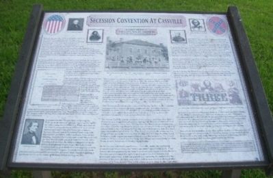
Secession Convention in Cassville Marker
| 1 ► Missouri, Barry County, Cassville — Secession Convention in Cassville — A State Divided — The Civil War in Missouri — |
| On Main Street. | |||
| 2 ► Missouri, Buchanan County, St. Joseph — The Civil War in St. Joseph — A State Divided: The Civil War in Missouri — |
| On Penn Street, on the left when traveling east. | |||
| 3 ► Missouri, Buchanan County, St. Joseph — The Patee House In The Civil War — A State Divided: The Civil War in Missouri — |
| On Penn Street at 12th Street, on the right when traveling east on Penn Street. | |||
| 4 ► Missouri, Cole County, Jefferson City — The State Capital During The Civil War — A State Divided: The Civil War in Missouri — |
| On High Street west of Washington Street, on the right when traveling west. | |||
| 5 ► Missouri, Cooper County, Boonville — Battle of Boonville — A State Divided: The Civil War in Missouri — |
| On Morgan Street, on the right when traveling east. | |||
| 6 ► Missouri, Dunklin County, Campbell — The Battle at Chalk Bluff — A State Divided — The Civil War in Missouri — |
| On County Route 228, on the left when traveling west. | |||
| 7 ► Missouri, Greene County, Springfield, Downtown Springfield — Battle of Springfield — A State Divided: The Civil War in Missouri — Missouri Department of Natural Resources — |
| On Park Central East east of South Avenue, on the left when traveling east. | |||
| 8 ► Missouri, Jackson County, Independence — First Battle of Independence — A State Divided: The Civil War in Missouri — |
| On Lexington Avenue near Main Street, on the right when traveling west. | |||
| 9 ► Missouri, Jackson County, Kansas City, River Market — General Orders No. 11 — A State Divided: The Civil War in Missouri — |
| On Delaware Street near 4th Street, on the right when traveling south. | |||
| 10 ► Missouri, Madison County, Fredericktown — Battle of Fredericktown — A State Divided: — The Civil War in Missouri — |
| On South Main Street (Business U.S. 67), on the right when traveling north. | |||
| 11 ► Missouri, Madison County, Fredericktown — The Eighth Wisconsin — A State Divided: — The Civil War in Missouri — |
| 12 ► Missouri, Marion County, Palmyra — Palmyra Massacre — A State Divided — The Civil War in Missouri — |
| On West Lafayette Street at South Dickerson Street, on the right when traveling west on West Lafayette Street. | |||
| 13 ► Missouri, Mississippi County, Belmont — The Battle of Belmont — A State Divided — The Civil War in Missouri — |
| On State Highway 80, on the right when traveling east. | |||
| 14 ► Missouri, New Madrid County, New Madrid — New Madrid & Island No. Ten — A State Divided: The Civil War in Missouri — |
| On Levee Road at Main Street, on the right when traveling east on Levee Road. | |||
| 15 ► Missouri, Newton County, Neosho — Secession Convention at Neosho — A State Divided: Civil War in Missouri — |
| On Spring Street near Wood Street, on the left when traveling west. | |||
| 16 ► Missouri, Newton County, Newtonia — First Battle of Newtonia — A State Divided: The Civil War in Missouri — |
| On Mill Street east of Market Street, on the right when traveling east. | |||
| 17 ► Missouri, Newton County, Newtonia — Second Battle of Newtonia — A State Divided: The Civil War in Missouri — |
| On Mill Street east of Market Street, on the right when traveling east. | |||
| 18 ► Missouri, Phelps County, Rolla — Fort Wyman — A State Divided: The Civil War in Missouri — Missouri Department of Natural Resources — |
| On West 3rd Street just west of North Rolla Street, on the left when traveling west. | |||
| 19 ► Missouri, Ray County, Richmond — The Bushwhacker in Missouri — A State Divided: The Civil War in Missouri — |
| On Thornton Street north of Main Street (State Highway 10), on the left when traveling north. | |||
| 20 ► Missouri, St. Louis, Kosciusko — St. Louis Arsenal — A State Divided: The Civil War In Missouri — |
| On Arsenal Street at Arsenal Street, on the right when traveling north on Arsenal Street. | |||
| 21 ► Missouri, St. Louis, Patch — Eads' Ironclads — A State Divided: The Civil War in Missouri — Missouri Department of Natural Resources — |
| On South Broadway just north of Courtois Street, on the left when traveling north. | |||
| 22 ► Missouri, Stoddard County, Bloomfield — The Civil War in Bloomfield — A State Divided: — The Civil War in Missouri — |
| On South Prairie Street (County Highway AA) at Court Street, on the left when traveling south on South Prairie Street. | |||
| 23 ► Missouri, Vernon County, Deerfield — Battles in the Marmaton Valley — A State Divided: The Civil War in Missouri — |
| On U.S. 54 at Old U.S. 54, on the right when traveling east on U.S. 54. | |||