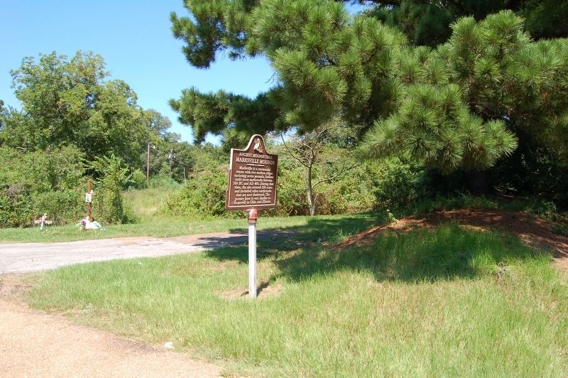
Marksville is a ceremonial center with two earthen ridges enclosing seven mounds. Indians built these earthworks between 100 BC and AD 400. During that time, the site covered 200 acres and included other earthworks that are now destroyed. The . . . — — Map (db m97726) HM
The Wade Landing site has a single platform mound. Indian pottery and soil studies suggest that the site is about 1000 years old. The mound was built in two stages and is 9 feet high and 130 by 165 feet at the base. Historic graves in the summit . . . — — Map (db m120507) HM
The Landerneau Mounds site is an
Indian village with two
dome-shaped mounds. People
lived here around AD 500. The
largest mound, with the cemetery
on top, is 442 feet tall and 130
feet in diameter. The other
mound is 3 feet tall and . . . — — Map (db m193796) HM
Alexander is a conical-shaped mound that is 10 1/2 feet tall and 98 by 130 feet at the base. It is the largest of 7 mounds that once stood here. The other 6 were only 1 1/2 to 5 feet tall. They have been reduced in size by plowing and are barely . . . — — Map (db m121568) HM
Boothe Landing is a 10-foot-tall conical mound that is well preserved. The oval-shaped base measures 82 feet by 60 feet. A village was just north of the mound. Decorated pottery found in the village area suggests Indians built the mound around . . . — — Map (db m120872) HM
Two Indian mounds make up the Harrisonburg Mounds site. The well-preserved conical mound that can be seen from here was built around AD 200. It is 10 feet high and 115 feet in diameter. The other mound is about 200 feet to the northeast. It is less . . . — — Map (db m103763) HM
McGuffee has as many as 6 mounds on the west bank of the Ouachita River. Several of the mounds are well preserved and visible from the road. A C-shaped earthen ridge encloses the mounds. Radiocarbon dates suggest Indians built these earthworks . . . — — Map (db m104674) HM
Routon has 7 mounds on the west bank of the Ouachita River. The 4 largest are rectangular with flat tops. The other 3 are dome shaped and less than 2 feet tall. The mound visible from the road is rectangular. It is 12½ feet tall and 230 by . . . — — Map (db m103811) HM
Tew Lake has 3 small, irregularly shaped mounds. The 2 in pasture on the south side of Routon Road are almost 4 feet tall. The one north of Routon Road has been reduced in height by plowing and is less than 3 feet tall. Soil studies and artifacts . . . — — Map (db m103782) HM
The 82-foot-tall "Great Mound" of Troyville once stood here. In 1936, Archaeologist Winslow Walker made this diagram, depicting the size and shape of the mound. Today, only 3 feet of mound fill remains. — — Map (db m103774) HM
An earthen wall and 9 mounds were once a prominent part of the landscape here. Early explorers described the largest mound or "Great Mound" as being 82 feet high, the tallest mound known in Louisiana. The earth-works were built between 100 BC and . . . — — Map (db m103781) HM
The Peck Mounds site has 5 mounds built along the bluff above Lake Louie. Only 4 mounds are visible today. The largest is platform shaped and measures 18 feet tall and 165 by 180 feet at the base. The smaller 3 are domed shaped and average only 4 . . . — — Map (db m87166) HM
Peck Village is a village and mound site where Indians lived between 100 BC and AD 1200. Archaeologist James A. Ford excavated here in 1933. He used a method called seriation to study the changes in pottery decoration through time. Based on pottery . . . — — Map (db m87165) HM
Churupa Plantation Mound was built around AD 1000. The mound was constructed in a single episode on top of the remains of an earlier Indian village. Plowing has altered the original conical shape. Today, the mound is 7 feet tall and 150 by 125 . . . — — Map (db m103784) HM
Cypress Grove is one of the best-preserved conical mounds in northeast Louisiana. This 10-foot-tall mound is 115 feet in diameter at the base. It was built in a single episode around AD 750. The pond north of the mound may be where soil was . . . — — Map (db m103806) HM
DePrato has 5 dome-shaped mounds, 3 of which are clearly seen from the road. Flooding has covered the ground and lower portions of the mounds with 2½ feet of sediment. Thus, the mounds appear smaller than their true height of 5-6 feet. . . . — — Map (db m103756) HM
Elkhorn is a 10-foot-tall platform mound that is 150 by 100 feet at the base. Construction of the mound began around AD 450. Soil studies indicated that dirt was added during a second state of construction. Pottery found here suggests that the . . . — — Map (db m103761) HM
Lamarque Landing is a conical mound that is 6½ feet tall and 115 feet in diameter. Indians built the mound about AD 1000. Excavations at the site revealed that the mound was built in 3 separate episodes. Lower Plaque This . . . — — Map (db m103810) HM
Frogmore is an Indian mound and village site that dates to about AD 700-1200. The mound is rectangular and was built in two separate episodes. It is 14 feet high, 157 by 190 feet at the base, and 60 by 72 feet at the summit. The mound was built . . . — — Map (db m10581) HM
Julice is a 9-foot-tall mound that is 130 by 65 feet at the base. The mound is rectangular with a flat top. However, it was square before the east side was altered for the highway. Pottery found near the mound suggests Indians built it around AD . . . — — Map (db m89788) HM
Transylvania once had up to 12 mounds. Only 6 are visible now. The mounds were rectangular in shape with flat tops prior to being altered in historic times. The largest is nearly 34 feet tall. It is in the center of the site and overlooks 2 plaza . . . — — Map (db m89789) HM
The mound here is a reconstruction
of the larger of 2 burial mounds
that archaeologists completely
excavated in 1938. The large mound
was 21 feet tall and dome shaped.
A smaller mound was 100 feet south
of the large one. It was 2 feet . . . — — Map (db m120190) HM
Fitzhugh once had 7 mounds and a linear earthen ridge leading to the site from the west. Now only 2 mounds remain. The largest is square with a flat top. It is 10 feet tall and 150 by 150 feet at the base. The smaller mound is 4 feet tall and 200 . . . — — Map (db m89061) HM
Schicker Mound is a 5-foot-tall platform mound that is 115 by 115 feet at the base. The age is unknown. The mound was 12 feet tall before the house was constructed on top in the 1920s. The LaSalle Street Mound, located only 300 feet due west, may . . . — — Map (db m89795) HM
Tendal is a platform mound with sides that face the four cardinal directions. It is 6½ feet tall and 165 by 230 feet at the base. The mound was flat on top even before the house was constructed. Artifacts found here suggest the mound was built . . . — — Map (db m89040) HM
Filhiol Mound is a 7-foot-tall
platform mound that measures
98 by 98 feet at the base. It
was built in two episodes.
The first episode was completed
around AD 700. An Indian village
extended from the mound to the
Ouachita River. An . . . — — Map (db m150313) HM
Insley once had up to 13 mounds. Only 2 are visible from the road. The closest one is 10½ feet tall and rectangular with a flat top. The mound farther north is 20 feet tall, but was 5 feet taller before fill was removed from its top. Indians . . . — — Map (db m121224) HM
Marsden is a group of 5 mounds that were once linked by a D-shaped ridge. The largest mound is platform shaped and is 13 feet tall and 150 by 150 feet at the base. The other 4 mounds are only 3 to 5 feet tall. People lived here as early as 1500 BC, . . . — — Map (db m105218) HM
Mayflower is a rectangular-shaped mound with a flat top. It was 10 1/2 feet tall, 130 by 130 feet at the base and 60 by 65 feet at the summit. The mound is well preserved, but the southeast corner was damaged during historic times. Decorated . . . — — Map (db m120580) HM
Sundown has 3 mounds that form
an equilateral triangle. Two of
the mounds are platform shaped
and one is dome shaped. The
largest measures 11 feet tall,
while the other two are less
than 8 feet tall. Decorated
pottery found in a . . . — — Map (db m120384) HM
Balmoral has 3 mounds that form an equilateral triangle. The one on this side of the road is 8 feet high and conical. The one farthest south and across the road is an 11 foot high platform mound. The one to the north of it is 9 feet high and . . . — — Map (db m51633) HM
The Ghost site consists of 3 earthen mounds. The largest is a platform mound measuring 11 feet tall and 118 by 92 feet at the base. The other 2 are about 1 foot tall and are dome shaped. Decorating pottery from the mounds indicate Indians lived at . . . — — Map (db m120435) HM
Shackleford is a ceremonial site with 4 mounds that date to about AD 800. Three of the mounds are 3 feet tall or less. However, the large platform mount is over 13 feet tall and is the best-preserved part of the site. It was constructed in several . . . — — Map (db m136949) HM
Flowery Mound is a rectangular
platform mound. The corners
are oriented to the cardinal
directions. Studies of the soil
in the mound suggest it was
built in a single episode
around AD 1000. It measures
165 by 130 feet at the base and
50 by . . . — — Map (db m119546) HM
Mound Plantation has a rectangular-shaped mound with a flat top. It is 10½ feet tall and 125 by 138 feet at the base. Pottery found near the mound suggests Indians built it around AD 800-1000. Lower Plaque This archaeological . . . — — Map (db m119543) HM
Scott Place is a 5-mound complex dating to around AD 1200. Four of the mounds are well preserved. The largest is a platform mound and is 11 feet tall. The other 4 are dome shaped and are more difficult to see from this spot. One is almost 7 feet . . . — — Map (db m121225) HM
Lower Jackson, located one-half mile south of this highway, was once thought to be part of the nearby Poverty Point site. However, charcoal found beneath the mound dates it to 3500 BC, 2000 years earlier than Poverty Point. The mound was built in . . . — — Map (db m109313) HM
Galloway Place, also known as Hodgkins Place, is a well-preserved conical mound on the eastern edge of Macon Ridge. It is 10 feet tall and 80 feet in diameter. Soil studied and artifacts suggest people lived here as early as 1700 BC, about the same . . . — — Map (db m167470) HM
Poverty Point is a complex of six mounds and six semi-circular ridges built about 1500 BC. The earthworks at this site were the largest in the Western Hemisphere at that time. Many of the artifacts found here show these Indians had an extensive . . . — — Map (db m109314) HM