141 entries match your criteria. Entries 101 through 141 are listed.⊲ Previous 100
Appalachian Iron Furnaces Historical Markers
Beginning in the 1700s converting iron ore into iron took place at isolated iron works close to ore sources. They were abandoned when raw materials were depleted, leaving their pyramidal stacked-stone furnaces to history.
On Pennsylvania Route 212 at Durham Road, on the left when traveling east on State Route 212.
Built in 1727. Original site at Durham. In blast until 1789, it made cannon and shot in the colonial wars and Revolution. Onetime owners included James Logan and George Taylor. — — Map (db m21786) HM
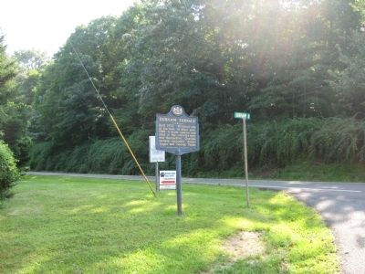
On Porter Road north of College Avenue (Pennsylvania Route 26), on the left when traveling north.
This trail passes through what was once the streambed of Thompson Run, a tributary of Spring Creek. The stream powered waterwheels that operated air bellows at the furnace and ran a gristmill and a sawmill.
Thompson Run was relocated off . . . — — Map (db m226625) HM
On Grays Woods Boulevard at Scotia Road on Grays Woods Boulevard.
Two miles southwest of here, an iron center called Scotia was established by Andrew Carnegie in 1881. Here houses were erected, a railroad built, and machinery set up. Some physical traces of the center have remained. — — Map (db m65600) HM
On South Eagle Valley Road (Alternate U.S. 220) 0.2 miles south of Twenty-eighth Division Highway, on the right when traveling south.
Along the streams of this region are ruins of many charcoal iron furnaces and forges built between 1790-1850. Juniata iron was the best in America. Its reign ended with the rise of coal and coke iron making. — — Map (db m74241) HM
On Porter Road (Pennsylvania Route 26) 0.5 miles east of University Drive, on the right when traveling east.
Here Colonels John Patton and Samuel Miles operated the first charcoal iron furnace in the region, 1792-1809. Present stack used 1825-1858. In this era Centre County led in the making of Juniata iron. — — Map (db m52431) HM
Iron manufacturing on this site launched Centre County industry, settlement, and the establishment of a major university-Pennsylvania State University.
In 1791, ironmasters Samuel Miles and John Patton bought over 16,000 acres to found . . . — — Map (db m226706) HM
Partner in Centre Furnace with James Irvin and instrumental in the selection of the site for the establishment of Penn State on furnace company land. Thompson resided here at the mansion for 49 years and hosted many trustee meetings and college . . . — — Map (db m52433) HM
On East College Avenue (Pennsylvania Route 26) at Porter Road, on the right when traveling west on East College Avenue.
This furnace stack was built in 1846 and replaced the original. It could produce as much as 1,500 tons of iron per year and operated until 1858.
Centre Furnace first went into "blast" and began making iron in 1792. When profits fell, the . . . — — Map (db m226629) HM
On Pennsylvania Route 58, 0.1 miles north of Main Street (Pennsylvania Route 368), on the right.
A short distance northwest of here is the well-preserved cold blast furnace, named for James Buchanan. It was built in 1844; abandoned, 1858, due to lack of timber. At the time of its operation, the iron industry was very prosperous in Clarion . . . — — Map (db m60100) HM
On Miola Road (Pennsylvania Route 1005) at White Oak Drive (Pennsylvania Route 1004), on the right when traveling west on Miola Road.
Just west of this point can be seen the well-preserved interior of cold blast furnace built in 1845. It was one of numerous iron furnaces operated in Clarion County from about 1829-1867. The County, then, was often referred to as "The Iron County." — — Map (db m59077) HM
On Market Street (Pennsylvania Route 879) at Reiter Street, on the right when traveling east on Market Street.
Near here stood the iron furnace erected 1817 by Peter Karthaus. Rebuilt 1836 by Peter Ritner and John Say, it became in 1839 one of the earliest to use coke in place of charcoal. Abandoned at the end of the same year. — — Map (db m77502) HM
On North Pitt Street north of West High Street (U.S. 11), on the right when traveling north.
First Block of North Pitt Street
Carlisle, PA (You are here)
The first block of North Pitt Street has seen many changes over the years. On the northeast corner of North Pitt and West High streets sits the Hamilton . . . — — Map (db m217335) HM
On Banning Road at Layton Road, on the right when traveling west on Banning Road.
First furnace west of the Alleghenies. Built 1789 on banks of nearby Jacob's Creek, its ruins are still observable. Supplied iron for Wayne's campaign in 1794 against the Indians. — — Map (db m41773) HM
On Pittsburgh Road (Pennsylvania Route 51) at Laurel Hill Road, on the right when traveling north on Pittsburgh Road.
In 1817 ironmaster Isaac Meason and Welshman, Thomas Lewis built a puddling furnace and bar rolling mill here using a process from Wales that revolutionized the iron industry. It removed carbon from brittle pig iron creating malleable wrought iron . . . — — Map (db m108156) HM
On Spruce Creek Road at Johnson Road on Spruce Creek Road.
The remaining buildings here were part of the iron works established about 1810. Operating first as a charcoal iron manufactory, the furnace later used coke. Iron was made here as late as 1888. — — Map (db m91028) HM
Near Shermans Valley Road (Pennsylvania Route 274) 0.4 miles east of Veterans Way (Pennsylvania Route 74), on the right when traveling west.
ca. 1842: African American settlement near Millerstown.
1850: Fugitive Slave Act enacted; Compromise of 1850.
1852: First fair by the Agricultural Society of Perry County
On East Main Street (Tennessee Route 100) at South Pleasant Street, on the right when traveling east on East Main Street.
13 miles southeast, this furnace was built, 1848. Iron was mined from nearby hematite deposits and processed here until 1876. The region is also known as “The Coalings”, because of extensive charcoal production here during iron mining . . . — — Map (db m63127) HM
On Buckfork Road, 0.2 miles east of Cedar Creek Road (County Route 1775), on the left when traveling east.
Tennessee’s iron industry was strategically important to both North and South. Numerous furnaces supplied iron to foundries to manufacture munitions as well as armor for ironclad vessels. The fall of Forts Henry and Donelson in February 1862 opened . . . — — Map (db m74987) HM
On Long Springs Road (Tennessee Route 339) at Newport Highway (Tennessee Route 411), on the left when traveling north on Long Springs Road.
5 miles northwest, this was first called Short Mountain Furnace, using local orebank ore. Started about 1820 by Robert Shields; William K. Love and brothers operated it about 1830. Micajah C. Rogers bought it and changed its name in 1836. It closed . . . — — Map (db m100497) HM
On The Trace (Tennessee Route 49) 0.1 miles south of Crockett Branch Rd, on the right when traveling north.
Built in 1854 by Brian, Newell & Co., this steam cold-blast charcoal furnace was built of limestone from the surrounding hills. Brown iron-ore came from shallow deposits about two miles north. Pig-iron was shipped by river or hauled to rolling mills . . . — — Map (db m39681) HM
On Rock Springs Road at Fort Henry Drive (Tennessee Highway 36), on the right when traveling west on Rock Springs Road.
Moses Cavett built the ironworks located here before 1795. Shortly after that year, John Sevier, his son and son-in-law acquired it. It was owned later by E. & E. Embree, east Tennessee ironmasters, whose Pactolus Nail Factory, located ¼ mile . . . — — Map (db m158110) HM
On Longdale Furnace Road (Virginia Route 269) at Collierstown Road (Virginia Route 770), on the right when traveling west on Longdale Furnace Road.
Australia Furnace, located just east of here, produced pig iron for the Tredegar Iron Works—“Ironmaker to the Confederacy”—during the Civil War. Ira and Edwin Jordan had begun constructing Australia Furnace in 1852; two years later, they put it in . . . — — Map (db m107981) HM
On Longdale Furnace Road (Virginia Route 269) at Collierstown Road (Virginia Route 770), on the right when traveling west on Longdale Furnace Road.
You are standing near the site of the Lucy Selina Furnace, which supplied the Confederacy with pig iron for the production of cannons, munitions, and rails during the Civil War. In 1827, two Scots-Irishmen, Col. John Jordan and John Irvine, built . . . — — Map (db m107982) HM
On Longdale Furnace Road (Virginia Route 269) at Iron Ore Lane, on the right when traveling west on Longdale Furnace Road.
This furnace was built in 1827 by ironmasters John Jordan and John Irvine and was named for their wives. During the Civil War, iron produced here was used in the manufacture of Confederate Munitions. — — Map (db m46386) HM
On Lee Highway (U.S. 11) north of Updike Lane, on the right when traveling north.
Robert Harvey established an agricultural and industrial complex here about 1790 that processed iron ore. The operation, known as Cloverdale Furnace, expanded in the 19th century under the ownership of John Tayloe III. About 150 enslaved African . . . — — Map (db m140513) HM
On Richmond Highway (U.S. 460) 0.1 miles east of Oxford Furnace Road (County Route 662), on the right when traveling west.
Just south across Little Beaver Creek stand the ruins of the last of three Oxford Iron Works furnaces built in the vicinity. Virginia and Pennsylvania investors began the ironworks nearby between 1768 and 1772 as a small bloomery forge. According to . . . — — Map (db m42897) HM
Near Pennlyn Avenue west of Llewelyn Street, on the right when traveling west.
From the early 1820s to the 1880s, an iron smelting business here took advantage of the rushing waters of Gap Creek. Today only the creek and part of the original 30-foot-high stone tower remain, a small part of an industrial complex of . . . — — Map (db m207276) HM
On Cub Run Road near Newport Road (County Route 685), on the right when traveling west.
Built in 1846, Catherine Furnace was one of three Page County furnaces in operation during the Civil War. The 30-foot-tall main stack is nearly all that remains of the cold blast furnace and once-huge operation here, when 22,500 acres supplied wood . . . — — Map (db m15892) HM
On State Highway 38, on the right when traveling west.
Iron ore was discovered here, 1835, by John Johnson. The Old Iron Furnace, built, 1848, was operated for six years by C.W. Bryant and Isaac Marsh. In 1850, a steam engine replaced the water power used to run fan air blast. Charcoal was fuel used. . . . — — Map (db m33929) HM
On Bloomery Pike (West Virginia Route 127), on the right when traveling east.
Bloomery Iron Furnace
The furnace was built, 1833, by Thomas Pastly and later was owned by Lewis Passmor. He placed a Mr. Cornwell in charge who operated it until 1848 when it was sold to S. A. Pancost. He and his heirs operated it until 1875 . . . — — Map (db m11019) HM
On Main Street (West Virginia Route 2) 0.1 miles north of Marland Avenue, on the right when traveling south.
Side A:Hancock CountyFormed in 1848 from Brooke. Named for John Hancock, first signer of the Declaration of Independence. Iron furnaces established in this county as early as 1794 made the cannon balls that Commodore Perry used in . . . — — Map (db m44127) HM
On West Virginia Route 2 at Kings Creek Road (County Route 11), on the right when traveling north on State Route 2.
Two miles east is the site of first blast furnace west of the Alleghenies. Built in 1794, it was the forerunner of the steel industry which flourished in this area. Here Peter Tarr cast cannon balls used by Perry on Lake Erie. — — Map (db m44138) HM
Near King's Creek Road at Patricia Drive, on the right when traveling west.
First iron furnace in N.W. Virginia built in 1790's on Campbell land by a man named Grant. Company of Grant & Partner failed CA. 1800. Deeded to Peter Tarr April, 1801, by pioneer James Campbell. Operations resumed by Connell, Tarr & . . . — — Map (db m80383) HM
On Charles Town Rd (West Virginia Route 9) at John Ressler Road on Charles Town Rd.
Thomas Mayberry agreed in 1742 to erect iron furnaces on the property of William Vestal. Here ore was mined and iron produced for the first time west of the Blue Ridge. Washington visited the iron furnaces here in 1760. — — Map (db m59576) HM
Can you imagine a bustling community here made up of hundreds of people, all with livelihoods centered around this old stone furnace? The Henry Clay Iron Furnace was the fiery heart fueling this small community, and reminds us of our historic . . . — — Map (db m109189) HM
Near County Line Drive (Local Route 73/12) south of Exit 15 (Interstate 68).
West, in Coopers Rock State Forest, is the Henry Clay cold blast furnace, built 1834-36 by Leonard Lamb. It had capacity of four tons pig iron per day, and furnished employment for 200 people. Sold to Ellicots in 1837. Operated until 1847. — — Map (db m145217) HM
On County Line Drive (Local Route 73/12) south of Exit 15 (Interstate 68).
Henry Clay Furnace, located on Quarry Run, was built between 1834 and 1836 by Leonard Laws for Tassey and Bissell. It was a cold-blast furnace and produced 4 tons of pig iron each 24 hours. It was one of several furnaces that were operated in this . . . — — Map (db m74511) HM
On North Preston Highway (West Virginia Route 26) 2.7 miles north of Albright, on the left when traveling north.
Harrison Hagans opened the Virginia Iron Furnace you see here in 1854. Except during the Civil War, the furnace operated intermittently until 1888.
Workers layered limestone, charcoal, and iron ore to forge pig iron that went into steel. A . . . — — Map (db m75121) HM
On North Preston Highway (West Virginia Route 26) 2.7 miles north of Albright, on the right when traveling north. Reported permanently removed.
Built by Harrison Hagans in 1852. This furnace and others were used to cast iron in frontier days. Early castings were made here for the Brandonville stove used by the early settlers west of the Ohio River. — — Map (db m169479) HM
On Veterans Memorial Highway (West Virginia Route 7) at Alpine Lake Road (County Route 46), on the right when traveling west on Veterans Memorial Highway.
Barbour County
Attractions
Alderson-Broaddus College. This private coeducational college is situated on a beautiful 170-acre campus overlooking Philippi, site of the first land battle of the Civil War. Its excellent performing arts . . . — — Map (db m239336) HM
141 entries matched your criteria. Entries 101 through 141 are listed above. ⊲ Previous 100