37 entries match your criteria.
Former U.S. Presidents: #41 George H.W. Bush Historical Markers
By Sandra Hughes, April 1, 2015
Gulf War-1991/War on Terrorism Marker
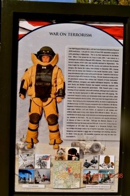
| 1 ► Alabama, Madison County, Huntsville — Gulf War-1991/War on Terrorism — |
| Near Monroe Street Northwest at Jefferson Street North, on the left when traveling east. | |||
| 2 ► Alabama, Mobile County, Mobile — It Takes a Village — |
| On North Claiborne Street at Dauphin Street, on the left when traveling south on North Claiborne Street. | |||
| 3 ► Alabama, Montgomery County, Montgomery — Chris’ Hot Dogs — Established In 1917 — |
| On Dexter Avenue east of South Perry Street, on the right when traveling east. | |||
| 4 ► Alabama, Montgomery County, Pintlala — Pintlala School — |
| On Federal Road (County Route 24) 0.3 miles Mobile Highway (U.S. 31), on the left when traveling west. | |||
| 5 ► Arkansas, Benton County, Bella Vista — United States Commanders in Chief — |
| 6 ► California, Merced County, Gustine/Santa Nella — San Joaquin Valley National Cemetery — |
| On West McCabe Road. | |||
| 7 ► Delaware, Kent County, Dover, Dover Air Force Base — VC-9C — S/N 73-1682 — |
| Near Heritage Road, 0.7 miles west of Bayside Drive (Delaware Route 9), on the left when traveling west. | |||
| 8 ► District of Columbia, Washington, Northwest Washington, Penn Quarter — The Extra Mile — Points of Light Volunteer Pathway — |
| On 15th Street Northwest at Pennsylvania Avenue Northwest, on the right when traveling north on 15th Street Northwest. | |||
| 9 ► District of Columbia, Washington, Southeast Washington, Barney Circle — Leonard P. Matlovich — |
| Near E Street Southeast, 0.2 miles east of Potomac Avenue Southeast, on the right when traveling east. | |||
| 10 ► Florida, Hillsborough County, East Lake-Orient Park — United Task Force (1992-1993) — Hillsborough County Veterans Memorial Park — |
| On U.S. 301, 0.2 miles south of East Dr. Martin Luther King Jr. Boulevard, on the right when traveling south. | |||
| 11 ► Florida, Hillsborough County, Tampa — Gen. Norman Schwarzkopf — 8/22/1934 - 12/27/2012 — |
| Near U.S. 301, 0.2 miles south of East Dr. Martin Luther King Jr. Boulevard, on the right when traveling south. | |||
| 12 ► Florida, Polk County, Lakeland — Operations Desert Shield/Desert Storm — Veterans Memorial Park — |
| Near Lake Beulah Drive, 0.1 miles north of Lime Street, in the median. | |||
| 13 ► Indiana, Marion County, Indianapolis, Mile Square — Robert D. Orr, 1917-2004 — |
| Near North Senate Avenue south of West Ohio Street, on the right when traveling south. | |||
| 14 ► Indiana, Vigo County, Terre Haute — Charles Luna — |
| Near North 8th Street south of Spruce Street. | |||
| 15 ► Kansas, Leavenworth County, Fort Leavenworth — General Colin L. Powell — American Statesman • American Son • American Soldier — |
| On Grant Avenue near Smith Lake, on the right when traveling north. | |||
| 16 ► Kentucky, Fayette County, Lexington — William S. Farish — 1939 - — |
| Near East Main Street (U.S. 60) at Midland Avenue (U.S. 60), on the right when traveling west. | |||
| 17 ► Louisiana, Ascension Parish, Gonzales — The Persian Gulf War — August 2, 1990-February 28, 1991 — |
| Near South Irma Boulevard, 0.3 miles north of East Worthey Street, on the right when traveling north. | |||
| 18 ► Maine, Cumberland County, Cape Elizabeth — Portland Head Light — |
| On Fort Williams Park. | |||
| 19 ► Maryland, Montgomery County, Silver Spring, Downtown Silver Spring — Veterans Plaza — |
| On Ellsworth Drive at Fenton Street, on the right when traveling north on Ellsworth Drive. | |||
| 20 ► Maryland, Washington County, Hancock — Veterans Memorial — |
| On Park Road, 0.1 miles north of West Main Street (Maryland Route 144), on the left when traveling north. | |||
| 21 ► Maryland, Worcester County, Ocean City — Smaller Conflicts After WWII — |
| On 24th Street just east of Philadelphia Avenue (Maryland Route 528), on the right when traveling east. | |||
| 22 ► Nebraska, Lancaster County, Lincoln — Ronald Reagan — 1911 - 2004 — |
| On Pine Lake Road near South 30th Street. | |||
| 23 ► New Jersey, Mercer County, Trenton, Downtown — World War II Memorial — |
| On West State Street, 0.1 miles west of North Willow Street, on the right when traveling west. | |||
| 24 ► New York, New York County, Manhattan, Governors Island — Reagan-Gorbachev Meeting 1988 — Quarters 403 — |
| On Clayton Road at King Road on Clayton Road. | |||
| 25 ► New York, Orange County, West Point — Twentieth Century Wars — |
| On Thayer Road at Brewerton Road on Thayer Road. | |||
| 26 ► Ohio, Franklin County, Columbus, Franklinton — 41-25 — Green Lawn Cemetery — |
| On Greenlawn Avenue, in the median. | |||
| 27 ► South Carolina, Chesterfield County, Cheraw — 13-6 — Dizzy Gillespie Birthplace — |
| On Huger Street, 0.1 miles north of McDonald Street, on the left when traveling north. | |||
| 28 ► South Carolina, Richland County, Columbia, Midtown - Downtown — Strom Thurmond — |
| Near Pendleton Street north of Main Street. | |||
| 29 ► South Dakota, Minnehaha County, Sioux Falls — Ronald Reagan — 1911-2004 — |
| Near W 41st St at Western Ave. | |||
| 30 ► South Dakota, Pennington County, Rapid City — The American Commitment — The Berlin Wall Memorial — |
| On Mount Rushmore Road. | |||
| 31 ► Texas, Andrews County, Andrews — Fight Against Terrorism — Andrews County Veterans Memorial — |
| On West Broadway Street at NW 6th Street, on the right when traveling west on West Broadway Street. | |||
| 32 ► Texas, Bexar County, San Antonio, La Villita — Commemorating — |
| On South Alamo Street south of East Nueva Street, on the right when traveling south. | |||
| 33 ► Texas, Dallas County, Dallas, North Dallas — 11839 — John Goodwin Tower — (1925-1991) — |
| Near West Northwest Highway, on the left when traveling east. | |||
| 34 ► Texas, Harris County, Houston, Theater District — Baker Common — |
| On Preston Street east of Bagby Street, on the right when traveling east. | |||
| 35 ► Texas, Midland County, Midland — 13058 — George Bush Family Home — |
| On North H Street north of West Ohio Avenue, on the right when traveling north. | |||
| 36 ► Virginia, Arlington County, Arlington, Fort Myer — America the Beautiful Memorial Grove — |
| On Sheridan Drive just north of Weeks Avenue, on the right when traveling north. | |||
| 37 ► Virginia, Arlington County, Arlington, Fort Myer — The Commander in Chief's Oak — |
| On Sheridan Avenue at Reba Place, on the right when traveling north on Sheridan Avenue. | |||