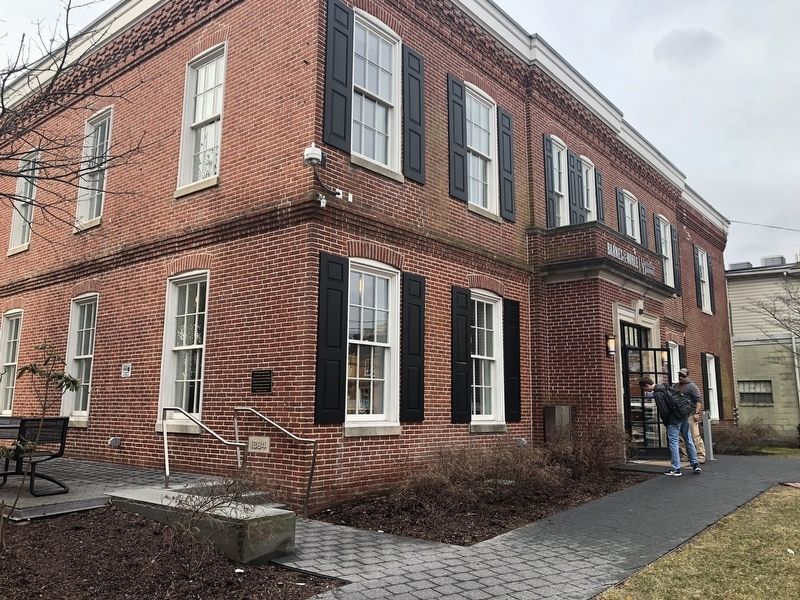
On East Main Street west of Academy Street, on the left when traveling west.
With deep gratitude for their commitment to education and service, the University of Delaware recognizes Albert Gallatin Lewis, his family and heirs, on whose land this building was built as a schoolhouse in 1884. — — Map (db m131156) HM
On The Green north of East Park Place, on the left when traveling south.
Some say the stars shine just a bit brighter over Cannon Hall, a residence hall built in 1952 and named for noted astronomer Annie Jump Cannon.
As curator of the Harvard College Observatory, Dr. Cannon classified 350,000 stars and discovered . . . — — Map (db m154026) HM
Near East Park Place west of Academy Street, on the right when traveling west.
Beatrice Hartshorn joined the Women's College at the University of Delaware in 1925 as head of the physical education program, which at the time consisted of rudimentary exercises and games.
Miss Hartshorn, who served on the University . . . — — Map (db m154035) HM
Near The Green south of East Delaware Avenue (Delaware Route 273), on the left when traveling north.
Under President Hullihen's leadership, the two colleges known as Delaware College and the Women's College were officially joined and became known as the University of Delaware in 1921. Two years later, Hullihen inaugurated the internationally . . . — — Map (db m154399) HM
On South College Avenue at West Delaware Avenue (Delaware Route 273), on the left when traveling north on South College Avenue.
This building is named in honor of E. Arthur Trabant, who served two terms as President of the University of Delaware: 1968-87 and 1988-90. During his presidency, enrollment at the University doubled, the Laird Campus was developed, the University . . . — — Map (db m131143) HM
On The Green north of East Park Place, on the right when traveling south.
Emalea Pusey Warner was one of the most influential women in the history of the University of Delaware. She was the first woman appointed to its Board of Trustees, serving from 1928-42.
The project closest to Mrs. Warner's heart was the . . . — — Map (db m131148) HM
Near South College Avenue at Kent Way, on the right when traveling north.
Son of a weaver in Northern Ireland, Dr. Francis Alison (1705-1779) was educated at Scotland's leading universities. He migrated to America, where he became the father of higher education in the middle colonies. In 1743 Alison founded the Academy . . . — — Map (db m154832) HM
On The Green north of East Delaware Avenue (Delaware Route 273), on the right when traveling north.
George Abram Harter served as President of Delaware College, now the University of Delaware, from 1896 to 1914. A quiet scholar who enjoyed teaching, he was an administrator respected for his unwavering dedication to the college.
Under his . . . — — Map (db m152709) HM
On The Green south of East Delaware Avenue (U.S. 273).
Delaware College, now University of Delaware, might have been a financial casualty of the Civil War period except for the assistance of George Gillespie Evans, a Newark merchant. Indeed, Delaware College did close for 11 years before, during and . . . — — Map (db m131107) HM
On The Green north of East Delaware Avenue (Delaware Route 273), on the left when traveling north.
During the height of the Great Depression, Harry Fletcher Brown first came to the aid of the University of Delaware and, over the next decade, became one of the University's most generous benefactors, financing construction of Brown Laboratory, . . . — — Map (db m154179) HM
On The Green south of East Delaware Avenue (Delaware Route 273).
An 1898 graduate of Delaware College, now the University of Delaware, Hugh Martin Morris was one of Delaware's most distinguished jurists, serving as a Wilmington attorney and, from 1919-30, as a U.S. District Judge for Delaware.
A member of . . . — — Map (db m154480) HM
On The Green south of East Delaware Avenue (Delaware Route 273), in the median.
To the students of the University of Delaware who died in the service of their country during Asian Conflicts
Bird, Leonard A. '66 — Vietnam •
Flaherty, Kevin G. '63 — Vietnam •
Johnson, James R., Jr. '56 — Vietnam • . . . — — Map (db m154201) WM
On The Green south of East Delaware Avenue (Delaware Route 273), on the left when traveling north.
To the men of the
University of Delaware
who died in the service of their country
during World War II
John H. Banks, III '46 •
Casimir L. Blaska '43 •
Robert J. Bostwick '31 •
Henry S. Brady, Jr. '34 •
Horace C. Brown '45 • . . . — — Map (db m154317) WM
Near East Main Street (Delaware Route 273) east of North College Avenue, on the right when traveling west.
Jastak-Burgess Hall, home of the Department of Foreign Languages and Literatures, is named in honor of psychologist Dr. Sarah Jastak-Burgess and Leslie M. Burgess ('43 B.S. UC Berkeley, '61 MBA Harvard). Their generous gifts in support of this . . . — — Map (db m154608) HM
On West Delaware Avenue (Delaware Route 273) west of Orchard Road, on the left when traveling east.
This building is named for renowned scholar John A. Munroe an authority on Delaware history and the author of many books, including a history of the University. After receiving his bachelor's and master's degrees from Delaware, he joined the . . . — — Map (db m154813) HM
On Academy Street north of Courtney Street, on the right when traveling north.
This building was named for John A. Perkins (1914-82), who served as President of the University of Delaware from 1950-67. His tenure marked one of the greatest periods of growth in the history of the University, with the undergraduate enrollment . . . — — Map (db m152056) HM
On The Green north of East Park Place, on the left when traveling south.
Kent Residence Hall, constructed in 1956, is named after Kent County, located in the central part of Delaware and home of the First State's capital city of Dover.
The adjoining Kent Dining Hall predates the residence hall by 31 years. The . . . — — Map (db m154027) HM
Near The Green south of East Delaware Avenue (Delaware Route 273), on the left when traveling south.
This laboratory is named for Lammot du Pont (1831-1884), a gifted scientist and grandson of the founder of the DuPont Company. His many talents resulted in new products and enhancements to the company's operation.
Recognized as a skilled . . . — — Map (db m130514) HM
On The Green north of East Park Place, on the right when traveling south.
This building is named for the small southern Delaware town of Laurel, the birthplace of Mary Wooten Carpenter. Her Husband, Walter S. Carpenter Jr., who served as President of the University of Delaware Board of Trustees from 1959-62, supported . . . — — Map (db m153415) HM
Located at the heart of The Green, Memorial Hall is a welcoming landmark and a signature building of the University of Delaware. The University community marks the passage of time by carillon music from atop the building, including hourly chimes, . . . — — Map (db m154917) HM WM
On South College Avenue at Kent Way, on the right when traveling north on South College Avenue.
The University of Delaware has a proud legacy of being a teaching University and accordingly, acknowledges faculty who are distinguished by their contributions of teaching excellence and mentorship of students. The first member of the University's . . . — — Map (db m154180) HM
On The Green north of East Park Place, on the left when traveling north.
This residence hall is named for the northernmost of Delaware's three counties, New Castle County. The City of Newark lies within its boundaries.
The dormitory was constructed with state funding in 1925, in response to the expansion of the . . . — — Map (db m131154) HM
On The Green south of East Delaware Avenue (Delaware Route 273), on the right when traveling north.
Pierre S. du Pont can fairly be described as the founder of the modern University of Delaware. In 1915, he donated the money to purchase the land that is now The Green, which physically unified Delaware College and Women's College.
President of . . . — — Map (db m131108) HM
On The Green south of East Delaware Avenue (Delaware Route 273), on the right when traveling north.
In 1871, Theodore Wolf joined Delaware College as a 21-year-old Professor of Chemistry, fresh from receiving his doctorate at the University of Heidelberg, Germany.
Professor Wolf was a demanding but innovative and popular teacher. He worked to . . . — — Map (db m131112) HM
On The Green south of East Delaware Avenue (Delaware Route 273), on the left when traveling north.
Robert ("Bob") Gore was a University of Delaware undergraduate studying chemical engineering when he invented GoreTexⓇ. This polymer material became key to the success of W.L. Gore and Associates, a company that Bob's father, Wilbert L. . . . — — Map (db m154281) HM
On The Green south of East Delaware Avenue (Delaware Route 273), on the left when traveling north.
In 1914, Samuel Chiles Mitchell was elected the 16th President of what was then known as Delaware College, now the University of Delaware.
During his six-year tenure as President, the Women's College was opened; the central campus was . . . — — Map (db m131105) HM
On The Green north of East Park Place, on the left when traveling south.
Squire Hall is named for Francis Hagar Squire, a popular Professor of History at the University from 1927-56, who also served as Dean of the College of Arts and Sciences from 1945-56.
Professor Squire helped establish the master's degree . . . — — Map (db m162072) HM
On East Cleveland Avenue at Paper Mill Road, on the right when traveling west on East Cleveland Avenue.
Newark was once the home of several factories producing paper, wood laminates and a variety of textiles. Some were located on the White Clay Creek. Harnessing its water flow to generate power. The Pomeroy and Newark Railroad service these . . . — — Map (db m174922) HM
Near South College Avenue north of Sunset Road, on the right when traveling north.
The beauty of the surrounding landscape on the University's South Green is the result of careful planning in the 1920s by one of the first female landscape architects in the United States, Marian Cruger Coffin. Miss Coffin designed and directed . . . — — Map (db m154197) HM
On The Green south of East Delaware Avenue (Delaware Route 273), on the right when traveling north.
In 1995, to celebrate the fifth anniversary of President David Roselle and his wife, Louise, at the University of Delaware, the Board of Trustees chose to name this section of campus, long known as The Grove, in recognition of the Roselles' service. . . . — — Map (db m154674) HM
The University of Delaware traces its origins to a school founded by the Rev. Francis Alison in 1743, which later became the Academy of Newark. In 1833, the state of Delaware chartered its first institute of higher education, called Newark . . . — — Map (db m154335) HM
On The Green south of East Delaware Avenue (Delaware Route 273), on the right when traveling south.
The University of Delaware traces its origins to a school founded by the Rev. Francis Alison in 1743, which later became the Academy of Newark. In 1833, the state of Delaware chartered its first institute of higher education, called Newark . . . — — Map (db m154472) HM
On The Green north of East Delaware Avenue (Delaware Route 273), on the left when traveling north.
Wilbur Owen Sypherd served as President of the University from 1944-46, and his administration accomplished much, including a major reorganization of the University's administrative structure, reinstituting coeducation and strengthening the . . . — — Map (db m131116) HM
On The Green north of East Park Place, on the right when traveling south.
When Winifred J. Robinson became the first Dean of the Women's College in 1914, the school consisted of a muddy field and two buildings under construction on what is now the south lawn of The Green.
Dr. Robinson visited every Delaware high . . . — — Map (db m131147) HM
Near Main Street (Delaware Route 273) near The Green, on the right when traveling west.
In honor of the men of rural New Castle County who entered the military service of their country on this spot during the World War — — Map (db m154808) WM
On Park Road south of Pilottown Road, on the right when traveling south.
The University of Delaware's 2-megawatt wind turbine generates clean power and represents an important contribution to renewable energy development in the United States.
Clean Energy
Using wind power reduces our use of fossil . . . — — Map (db m113701) HM
Near Rehoboth Avenue (Delaware Route 1A) at Canal Street, on the right when traveling west.
The canal carried a variety of items including building materials, farm products, oysters, fish and ice. Shortly after it opened, however, there was a huge increase in the use of trucks to bring goods to market. A corresponding increase in the . . . — — Map (db m198886) HM
Near Rehoboth Avenue (Delaware Route 1A) at Canal Street, on the right when traveling west.
The Lewes Rehoboth Canal is ten miles long and connects the Delaware Bay with Rehoboth Bay. It was built so that agricultural products could be shipped from the area around Rehoboth Bay to the Delaware Bay and then on to Baltimore and . . . — — Map (db m198885) HM
On Rehoboth Avenue (Delaware Route 1A) at Canal Street, on the right when traveling west on Rehoboth Avenue.
Boating along the canal has always been popular. In the early days, locals used the flat-bottomed barges to travel and see the sights. Today, locals and tourists frequently used private boats on the canal especially during the summer . . . — — Map (db m198883) HM