Near Monument Ave., on the left when traveling south.
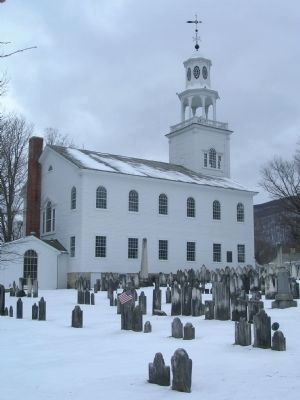
Whereas, the Old First Church of Bennington was
organized December 3, 1762, and is the Oldest Church
within the present limits of Vermont; and
Whereas, our forefathers met in Prayer in the First
Meeting House for assistance against the . . . — — Map (db m28223) HM
On Mad Tom Road at Village Street, on the right when traveling north on Mad Tom Road.
Bill Wilson was born November 26, 1895, in a room behind the bar at the Wilson House Hotel. From age 11 until entering the Army, he lived at the Griffith House across the church yard from his birthplace. Bill W. wrote the book "Alcoholics Anonymous" . . . — — Map (db m94430) HM
Near Center Street at Cemetery Circle, on the left when traveling north.
Built by the Town of Lyndon in the summer of 1809 as a meeting house for the religious services of four congregations – Baptist, Congregational, Methodist, and Universalist – and for town meetings. The “Town House” was . . . — — Map (db m136690) HM
On Main Street (U.S. 2) at Church Street, on the right when traveling west on Main Street.
Had you stood at this location in the early 1800s, you would have had to lift your skirt off the dirt lane to step up onto the plank sidewalk or guard your hat from the danger of low wooden canopies. Pedestrians competed with horse and carriage on . . . — — Map (db m23579) HM
On Battery Street at Cherry Street, on the right when traveling south on Battery Street.
Beginning in the early 1900s, the area directly to the east housed numerous emigrants. Many moved here from Italy with hopes to build better lives. Some worked in the lumber mills and railroad yards that bordered the lake. In the process, they . . . — — Map (db m75562) HM
On Pearl Street at Church Street, on the right when traveling west on Pearl Street.
Designed by noted architect Peter Banner of Boston, the Federal-style Meeting House was built in 1816 for the First Congregational Society (Unitarian) and is the oldest surviving place of worship in Burlington. Banner's design features a projecting . . . — — Map (db m97755) HM
"We consider it criminal in the sight of God and man, longer silently to submit to our indignities, or suffer them to be transmitted to posterity." Andrew Harris was one of the first African Americans to earn a college degree. The antislavery . . . — — Map (db m97754) HM
The Round Church This 16-sided church, Richmond's first meeting house, was built by a group led by William Rhodes in 1812-12 on land donated by Issac Gleason & Thomas Whitcomb. The first Proprietors were members of five denominations: Baptist, . . . — — Map (db m76387) HM
Charlotte Meeting House was built by the community's Methodist congregation. The building's architectural details reflect Greek design influences, including the triangular pediment created by cornice moldings. During the building's 112-year history . . . — — Map (db m109101) HM
This building originally served a large Shaker community in Canterbury, New Hampshire, as a one-story horse and carriage stand. The simple, unadorned commercial structure was expanded in 1850 to provide storage space for brooms made and sold by . . . — — Map (db m109172) HM
On Church Street east of Shelburne Road (U.S. 7), on the right when traveling east.
Scripture
1800 • The First Society
Tradition
1834 • The Brick Church
Experience
1872 • The Stone Church
Reason
2000 • The Bicentennial Addition — — Map (db m109237) HM
This building was designed to complement neighboring historic structures. The main block, flanked by matched wings, echoes the symmetry and scale of nearby Dorset House, and the brick façade reflects the construction materials of the Schoolhouse . . . — — Map (db m109476) HM
On N Main Street (Vermont Route 118) at Deuso Road, on the left when traveling west on N Main Street.
The Episcopal Union Church was the first religious edifice built in Montgomery. John Henry Hopkins, the first Episcopal Bishop of Vermont, consecrated the new church in 1835. Originally designed as a traditional meeting house, extensive renovations . . . — — Map (db m201055) HM
On Shrine Road, 0.1 miles north of St. Anne's Road.
On this shore was the site of Fort Ste. Anne built in 1666 by Capt. Pierre La Motte for defense against the Mohawks. The Jesuits celebrated the first Mass and erected the first Chapel. Though not permanent, this was Vermont's first white . . . — — Map (db m74721) HM
On Grand Army of the Republic Highway East (Vermont Route 15) 0.2 miles west of School Street, on the right when traveling west.
Reverend Brown was the first African American Methodist minister in Vermont. He was born in Newport, RI and became a Methodist minister in Kingsbury, NY in 1833. He made a living by building stone walls; many of which are still standing today. . . . — — Map (db m77582) HM
On Middlebrook Road at Bear Notch Road, on the left when traveling north on Middlebrook Road.
Revolutionary War patriot and author of the popular ode "The American Hero," written in celebration of the Battle of Bunker Hill, Nathaniel Niles was an original settler of Fairlee, then founder of West Fairlee, and first minister of this church. He . . . — — Map (db m65091) HM
On Hinman Settler Road north of Old Stone House Road, on the left when traveling north.
The Orleans County Grammar School was built at the foot of Prospect Hill in 1823 by William Baxter, a prominent citizen of Brownington. He asked that worship services for the Congregational Church be held on the second floor until a permanent . . . — — Map (db m221755) HM
1799 First worship service held in home of Timothy Hitman
1807 Congregational Society of Derby formed by settlers
1816 Members form Stanstead QC Congregational Church
1820 First Derby Congregational Church building erected
1823 Members . . . — — Map (db m208173) HM
On E Main Street, on the right when traveling west.
One of the first Methodist churches erected in Vermont, the Old Stone Church was built ca. 1822 with limestone from Whitehall, NY, and marble quarried in Tinmouth, VT. The church, set high atop Stone Church Hill, created a town center and prompted . . . — — Map (db m233726) HM
On Main Street, on the right when traveling north.
The earliest marble was quarried by the Humphrey brothers in 1836. They were followed by successive marble companies. In 1870 Redfield Proctor took over in receivership and brought the Vermont Marble Company to world prominence. Building contracts . . . — — Map (db m77969) HM
On Court Street, 0.1 miles north of Center Street, on the right when traveling north.
Julia Dorr, who lived in Rutland during childhood and from 1857 until her death, was one of Vermont's most famous and best loved poets. She published hundreds of popular poems, sonnets, and prose works, which reflect a keen sense of observation and . . . — — Map (db m78001) HM
On Lamb Hill Road, 0.5 miles east of Saw Mill Hill Road, on the left when traveling east.
Oliver Cowdery, born here on 3 October 1806, was the principal scribe for the translation of the Book of Mormon and was one of three special witnesses to its divinity. He assisted the prophet Joseph Smith in organizing The Church of Jesus Christ of . . . — — Map (db m108750) HM
On Pleasant Street, on the left when traveling north.
Lemuel Haynes, born in West Hartford, CT, in 1753, was the son of mixed race parents. Indentured at the age of 5 months to a devout churchman, Haynes was an ardent student of the Bible. In 1785, he became the first ordained African American . . . — — Map (db m133927) HM
On Meetinghouse Road at Athens Road (Vermont Route 35), on the left when traveling south on Meetinghouse Road.
Old Brick Church
has been placed on the
National Register of
Historic Places in 1979
by the United States
Department of the Interior. — — Map (db m179128) HM
On Rockingham Road (Vermont Route 103) at Missing Link Road, on the right when traveling north on Rockingham Road.
At The Mouth of the Williams River
A Few Rods East of This Place
Rev. John Williams
A Deerfield Captive
On Sunday, March 5, 1704
Preached the First Protestant Sermon
Delivered in the Territory that Later
Became the State of Vermont . . . — — Map (db m98044) HM
On Western Avenue (Vermont Route 9) near South Street, on the left when traveling west.
Glenwood Ladies’ Seminary opened in September 1860, with Hiram Orcutt as founder and principal. It was among the 19th-century examples of private secondary boarding schools for females in Vermont. The course of study included Composition, Logic, . . . — — Map (db m150443) HM
On Kimball Hill Road at Frost Road on Kimball Hill Road.
Eldest son of a Putney family, John Noyes (1811-1886) became deeply religious after a revival meeting in 1831. Convinced that Christ’s Second Coming had occurred in 70 A.D. and that all people could now be free of sin, he became a . . . — — Map (db m65770) HM
On Rockingham Road (Vermont Route 103) west of Meetinghouse Road, on the left when traveling west.
The Rockingham Meeting House is one of the finest remaining examples of New England Colonial architecture. It is the oldest intact public building in Vermont. Built between 1787 and 1801, it served Rockingham as a house of religious worship and . . . — — Map (db m115806) HM
Near Meetinghouse Road south of Rockingham Road (Vermont Route 103), on the left when traveling east.
Rockingham Meetinghouse has been designated a National Historic Landmark This site possesses national significance in commemorating the history of the United States of America A rare 18th century New England meetinghouse of the "Second Period," . . . — — Map (db m72023) HM
On Fort Bridgman Road (Vermont Route 142) west of Greenway Drive, on the right when traveling west.
The first Vernon Union Church was built in 1845 for the Universalist society. Anna Marsh, daughter of Lt. Gov. Jonathan Hunt, bequeathed $2,000 to Vernon, “for the support of preaching” in the town. The church has received this support since 1834 . . . — — Map (db m185954) HM
On Pond Road, 0.1 miles north of Huckle Hill Road, on the left when traveling north.
Built 1860 by the
Second Advent Society
Restored 1969 by
Vernon Historians Inc.
Listed on the National Register of Historic Places — — Map (db m230497) HM
On Pond Road just north of Huckle Hill road, on the left when traveling north.
Pond Road Chapel has been placed on the National Register of Historic Places in 1985 by the United States Department of the Interior — — Map (db m230507) HM
On Vt. Route 100 (Vermont Route 100), on the right when traveling south.
The leader of the Mormon pioneers, Brigham Young, was born up the steep hill to the south on June 1, 1801. He eventually led his people from Illinois to Utah where he founded Salt Lake City in 1847 and 500 communities throughout the west. Young . . . — — Map (db m61306) HM
On Stimpson Hill Road, 0.1 miles south of Vermont Route 100, on the left when traveling south.
The structure, originally of Greek Revival design, was built in 1861 as a Universalist Church. As its membership declined toward the end of the 19th century, the Congregation found it necessary to relinquish ownership to a community association, . . . — — Map (db m75699) HM
On Church Street (Vermont Route 12) at Lower Church Street, on the right when traveling west on Church Street.
Eighteen Hundred and Froze to Death The year 1816 was known worldwide as "the cold year", "the famine year", and "the year without a summer". Vermonters called it "Eighteen Hundred and Froze to Death", as snow fell on June 7 and frosts came . . . — — Map (db m156421) HM
On High Street, 0.2 miles west of Main Street (Vermont Route 103), on the right when traveling east.
Born in Ludlow in 1828 and educated at Black River Academy, Abby Maria Hemenway was the editor of the Vermont Historical Gazetteer, a five volume compilation of local history, published between 1860 and 1891. For thirty years, Hemenway . . . — — Map (db m78155) HM
On Route 14 (Vermont Route 14) at Dairy Hill Road, on the right when traveling north on Route 14.
Joseph Smith, founder of the Church of Jesus Christ of Latter-day Saints, was born near here on December 23, 1805. A visitor's center and a 38½ foot tall monument, considered the world's largest polished granite shaft, commemorates his life and is . . . — — Map (db m37198) HM
On Main Street (U.S. 5) south of River Street, on the right when traveling south.
Mount Ascutney & Its People
Towering over the landscape at 3,150 feet, Mount Ascutney — visible beyond the trees at the back of the cemetery — influenced the economic, social, and cultural life of the town. As early as 1808, granite . . . — — Map (db m180679) HM
On Elm Street (Vermont Route 12) at Pleasant Street (Vermont Route 12), on the left when traveling north on Elm Street.
Installed in the belfry of
this church and dedicated
to the glory of God in 1818,
it called to worship the
faithful in Jesus Christ
for 156 years. — — Map (db m133903) HM