After filtering for Nevada, 42 entries match your criteria.
Natural Resources Topic
By Syd Whittle, July 6, 2009
Historic Flume and Lumberyard Marker
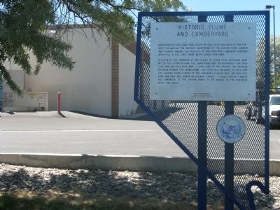
| 1 ► Nevada, Carson City — 193 — Historic Flume and Lumberyard — |
| Near South Carson Street (U.S. 395/50). | |||
| 2 ► Nevada, Clark County, Boulder City — 6 — Eldorado Canyon — Head of Steamboat Navigation in Nevada — |
| On U.S. 95 at Nevada Route 165, on the left when traveling south on U.S. 95. | |||
| 3 ► Nevada, Clark County, Boulder City — Hoover Dam and Lake Mead — |
| On U.S. 93, on the right when traveling west. | |||
| 4 ► Nevada, Clark County, Goodsprings — Good's Spring — |
| On San Pedro Street, on the right when traveling east. | |||
| 5 ► Nevada, Clark County, Goodsprings — 102 — Goodsprings Mining District 1856 - 1957 — |
| On Spring Street, 0.1 miles west of Vegas Street, on the left when traveling west. | |||
| 6 ► Nevada, Clark County, Las Vegas, Charleston — 1 — Las Vegas Springs — 8000 B.P. — |
| On South Valley View Boulevard at Meadows Lane, on the right when traveling north on South Valley View Boulevard. | |||
| 7 ► Nevada, Clark County, Las Vegas, Rancho Oakey — First Water Company — |
| Near South Valley View Boulevard at West Charleston Boulevard. | |||
| 8 ► Nevada, Clark County, Nelson — 6 — El Dorado Canyon — |
| On Nevada Route 165, 12.9 miles east of U.S. 95, on the left when traveling east. | |||
| 9 ► Nevada, Clark County, Nelson — 6 — El Dorado Canyon — |
| On Nevada Route 165, 11.2 miles east of U.S. 95, on the right when traveling east. | |||
| 10 ► Nevada, Clark County, Nelson — Techatticup Mine — |
| On Nevada Route 165, 12.9 miles east of U.S. 95, on the left when traveling east. | |||
| 11 ► Nevada, Douglas County, Genoa — 120 — Walley's Hot Springs — |
| Near Foothill Road (Nevada Route 206), on the right when traveling north. | |||
| 12 ► Nevada, Elko County, Elko — 229 — Oil From Shale — |
| On West Idaho Street (Nevada Route 535) near Hot Springs Road, on the right when traveling east. | |||
| 13 ► Nevada, Esmeralda County, Blair Junction — 155 — Silver Peak — |
| On Highway 6 at Highway 265, on the right when traveling east on Highway 6. | |||
| 14 ► Nevada, Esmeralda County, Gold Point — Gold Point — |
| On Gold Street, 15 miles south of U.S. 95, on the left when traveling south. | |||
| 15 ► Nevada, Esmeralda County, Goldfield — 156 — Gold Point — |
| On State Highway 266 at State Highway 71 (State Route 774), on the right when traveling west on State Highway 266. | |||
| 16 ► Nevada, Eureka County, Carlin — Beowawe Geysers — |
| Near Interstate 80 at milepost 258, on the right when traveling east. | |||
| 17 ► Nevada, Eureka County, Eureka — 254 — The Eureka Mining District — Producing Ore Since 1864 — |
| On U.S. 50 at milepost 33.3 at Nevada Route 278, on the right when traveling east on U.S. 50. | |||
| 18 ► Nevada, Lincoln County, Panaca — Panaca Summit Charcoal Kilns — |
| 19 ► Nevada, Lincoln County, Pioche — 204 — Jackrabbit — |
| On U.S. 93 at milepost 132, on the left when traveling north. | |||
| 20 ► Nevada, Lincoln County, Pioche — 5 — Pioche — |
| On Main Street (Nevada Route 321) 2.4 miles west of U.S. 93, on the left when traveling west. | |||
| 21 ► Nevada, Nye County, Amargosa Valley — A Changing Landscape — |
| Near Point of Rocks Road, 1.5 miles east of Spring/Ash Meadows Road. | |||
| 22 ► Nevada, Nye County, Amargosa Valley — Cultural Clues to the Past — |
| Near Point of Rocks Road, 1.5 miles east of Spring/Ash Meadows Road. | |||
| 23 ► Nevada, Nye County, Round Mountain — 96 — Round Mountain — |
| On U.S. 376, on the left when traveling north. | |||
| 24 ► Nevada, Nye County, Tonopah — "Big" Bill Murphy — |
| On Veterans Memorial Highway (U.S. 6) at Bryan Avenue, on the left when traveling north on Veterans Memorial Highway. | |||
| 25 ► Nevada, Nye County, Tonopah — The Hoistmen — |
| On Burro Avenue, on the right when traveling east. | |||
| 26 ► Nevada, Nye County, Tonopah — 172 — Tybo — Silver-Lead-Zinc Camp — |
| On U.S. 6, on the right when traveling north. | |||
| 27 ► Nevada, Storey County, Virginia City — 6 — Chollar – Potosi Mining Co. — Comstock Historical Landmark No. 6 — 615 South F. Street, Virginia City, NV — |
| On South D Street, on the right when traveling north. | |||
| 28 ► Nevada, Storey County, Virginia City — 209 — Chollar Mine — |
| On F Street at Nevada Route 341 on F Street. | |||
| 29 ► Nevada, Storey County, Virginia City — 4 — Combination Shaft — Chollar – Potosi, Hale & Norcross and the Savage Mines — Comstock Historical Marker No.4 — |
| On Nevada Route 341 near Nevada Route 342, on the right when traveling north. | |||
| 30 ► Nevada, Storey County, Virginia City — 12 — Consolidated Virginia & California Pan Mill — Upper end of Six Mile Canyon (Mill Street), Virginia City — Comstock Historical Marker No. 12 — |
| On E Street. | |||
| 31 ► Nevada, Storey County, Virginia City — 11 — Hale & Norcross Mining Co. — Comstock Historical Marker No. 11 — South D Street, Virginia City, NV — |
| On South D Street. | |||
| 32 ► Nevada, Storey County, Virginia City — 132 — Mackay Mansion — |
| On South D Street, on the right when traveling north. | |||
| 33 ► Nevada, Storey County, Virginia City — Ophir Grade — |
| On South C Street (State Highway 341), on the left when traveling north. | |||
| 34 ► Nevada, Storey County, Virginia City — 3 — Savage Mining Co. — Comstock Historical Marker No. 3 — |
| On North D Street. | |||
| 35 ► Nevada, Storey County, Virginia City — 16 — The Big Bonanza — Virginia City, Nevada — Comstock Historical Marker No. 16 — |
| On E Street. | |||
| 36 ► Nevada, Storey County, Virginia City — 13 — The Comstock Lode — 1864 – 1964 — |
| On C Street (Nevada Route 341), on the right when traveling north. | |||
| 37 ► Nevada, Storey County, Virginia City — The Comstock Trail and History Kiosk — |
| On Washington Street at R Street on Washington Street. | |||
| 38 ► Nevada, Washoe County, Nixon — Guanomi Mine — |
| On Sutcliffe Highway (Nevada Route 446) near Pyramid Lake Road (Nevada Route 445), on the left when traveling north. | |||
| 39 ► Nevada, Washoe County, Reno — 267 — Galena Creek Fish Hatchery — |
| Near Mount Rose Highway. | |||
| 40 ► Nevada, Washoe County, Reno — 198 — Steamboat Springs — |
| On Alternate U.S. 395, 0.2 miles north of Rhodes Road, on the right when traveling north. | |||
| 41 ► Nevada, White Pine County, Ely — 51 — Schellbourne — |
| On U.S. 93 at milepost 93, on the right when traveling north. | |||
| 42 ► Nevada, White Pine County, Ely — The Liberty Pit — Robinson Mining District — |
| On East Aultman Street (Lincoln Highway) (U.S. 50) at 4th Street, on the right when traveling east on East Aultman Street (Lincoln Highway). | |||