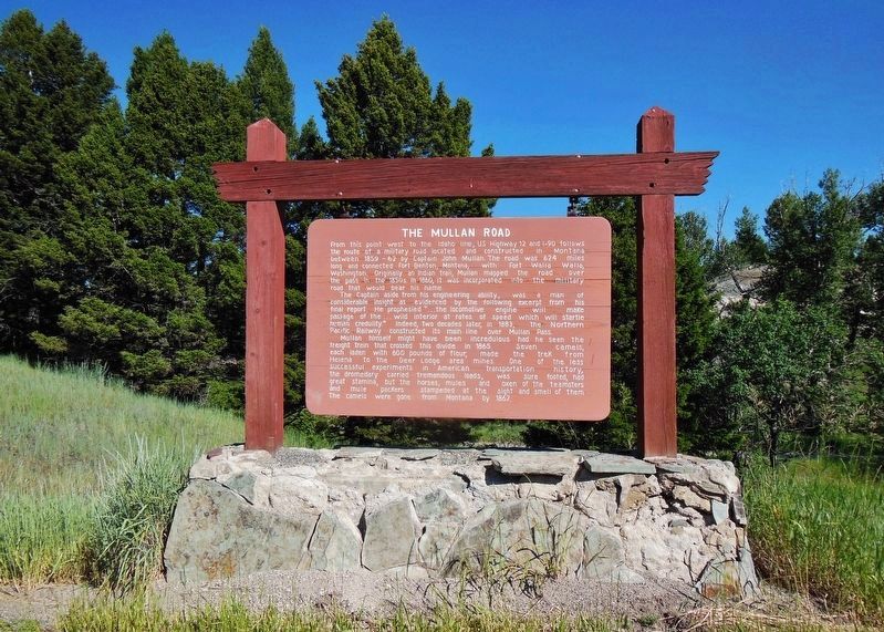
From this point west to the Idaho line, US Highway 12 and I-90 follows the route of a military road located and constructed in Montana between 1859 - 62 by Captain John Mullan. The road was 624 miles long and connected Fort Benton, Montana, with . . . — — Map (db m71950) HM
While the construction of the Northern Pacific Railway was an epic undertaking, the celebration to mark its completion was less than extraordinary. The railroad's president, Henry Villard, planned a last spike ceremony for September 8, 1883 near the . . . — — Map (db m212232) HM
• A conference of businessmen from South Dakota in 1912 met to build a better road between Ipswich and Aberdeen, SD. This led to the development of the Yellowstone Trail which stretched from "Plymouth Rock to Puget Sound". • The Yellowstone Trail . . . — — Map (db m202882) HM
With material and manpower redirected to winning the fight against fascism, commercial and domestic construction practically ceased during World War II. After the war, pent up demand led to a mini construction boom. With very few lots left on the . . . — — Map (db m123588) HM
The is one of the first and oldest brick buildings in town.
In 1893 the Hunter Building was used as a saloon. Due to the Temperance movement in the early 1900s the saloon's license was revoked.
After this time it went through a series . . . — — Map (db m123386) HM
This marker is composed of three panels on a common support
The Mystery May Never be Solved
Experts disagree on the exact route Lewis and Clark took over this divide. No one knows where they camped on that cold snowy night . . . — — Map (db m109625) HM
About 65 million years ago, the inland sea receded as the Rocky Mountains rose, pushing the shoreline further east. Great rivers meandered through the coastal plain in a warm and humid climate, depositing sediment which would later become known as . . . — — Map (db m164492) HM
"They go to Buffalo twice a year - first, 'to bulls' ... second 'for cows' ..." 1857, R.H. Lansdale, Indian Agent, Washington Territory
At Horse Plains "... a village of Indians collected here who never go for buffalo ..." . . . — — Map (db m219341) HM
The nearby Bad Rock Trail was an important route for the aboriginal people who inhabited northwest Montana. The first documented account of the trail was by North West Company trader David Thompson in 1809. Located within sight of the company's . . . — — Map (db m219346) HM
Seeing the country being denuded of beaver, Thompson wrote: "Every intelligent man saw the poverty that would follow the destruction of the beaver, but there were no chiefs to control it; all was perfect liberty and equality." David . . . — — Map (db m219424) HM
In 1910, Butte had only three automobile-related businesses, one of which also repaired bicycles, typewriters, slot machines, and revolvers. By 1918, auto dealers, repair shops, garages, and tire stores numbered over fifty. “No other town in Montana . . . — — Map (db m185410) HM
The Bozeman Trail crossed the divide from Red Lodge Creek and descended a steep hillside to the Rosebud valley one-half mile southeast of here. Jim Bridger opened the route through this area in June 1864, and three weeks later John Bozeman followed . . . — — Map (db m190706) HM
The Bozeman Trail was located ten miles south of here. John Bozeman pioneered the trail in this area in July 1864. After crossing the Bighorn River eight miles below the opening of the Bighorn Canyon, he led his wagon train northwest to the . . . — — Map (db m4326) HM
For over sixty million years during the Cretaceous Period, much of eastern Montana was underwater, covered by an vast inland sea. As the Rocky Mountains formed to the west, it created a broad, flat coastal plain that was home to many different . . . — — Map (db m190925) HM
For over sixty million years during the Cretaceous Period, much of eastern Montana was underwater, covered by an vast inland sea. As the Rocky Mountains formed to the west, it created a broad, flat coastal plain that was home to many different . . . — — Map (db m29123) HM
The Bozeman Trail descended from the high plateau to the Yellowstone River on the east side of Bridger Creek. The trail crossed the creek and then continued one mile to the Yellowstone. From there, the trail went west along the south bank of the . . . — — Map (db m191050) HM
In 1866, Nelson Story and two dozen cowboys drove six hundred longhorn cattle from Texas over 1400 miles to the Livingston area in Montana. The journey was an epic one, the stuff of countless Hollywood Westerns.
The Montana mining camps provided . . . — — Map (db m191041) HM
You are now following the historic trail of the Lewis and Clark Expedition. On his return from the Pacific in July 1806, Captain Clark camped for six days about forty miles downstream, near Park City. The Expedition had been looking for timber . . . — — Map (db m28948) HM
From 1869 to 1885, supplies and trade goods that came up the Missouri River from St. Louis were transferred at Fort Benton from steamboats to freight wagons for distribution in southern Alberta on the famed Whoop-up Trail, which ran near here. In . . . — — Map (db m220444) HM
At least three generations of motorists have depended upon the courteous, reliable service provided by this longtime Shelby landmark, designed by Continental Oil Company (Conoco) architects and built in 1936. As an adaptation of the competing Pure . . . — — Map (db m161239) HM
The Whoop Up Trail came into being in the late 1860's. It headed northwest from Fort Benton to Fort Whoop Up which was built before the broader between Canada and the United States was surveyed. The trail extended to Fort Macleod when that outpost . . . — — Map (db m161388) HM
When William Clark passed through this area on July 27, 1806, he described "estonishingly noumerous" bison and elk as well as his last glimpse of the snow-clad Big Horn Mountains. Most importantly, his report of abundant beaver "sign" quickly drew . . . — — Map (db m165322) HM
For thousands of years, northern Montana was covered under massive ice sheets. Glaciologists aren't sure why the ice ages began, but the process of glaciation is known because of the mark it leaves on the landscape. About 190,000 years ago, . . . — — Map (db m142928) HM
In the years leading up to Prohibition, more than a dozen local shops sold cigars and tobacco. In 1917, Billings claimed five cigar factories.
When Prohibition outlawed alcohol and shut down saloons, it indirectly undercut the tobacco industry . . . — — Map (db m165960) HM
This prominent building, situated across from the railroad depot, was also known as "Enterprise Garage and Sales" and was a repair shop for many years. It was recently renovated to house several retail businesses. — — Map (db m166179) HM
The town of Billings is named for Frederick Billings. He was a gold rush lawyer, railroad baron, and conservationist. Born and educated in Vermont, he arrived in California with his law degree during the 1849 gold rush. He was California's first . . . — — Map (db m168301) HM
The homesteading boom was in full swing in 1910, but not all of Montana's newcomers came to farm. With the arrival of three transcontinental railroads, Billings became established as a regional hub of commerce. Many businesses saw opportunity in the . . . — — Map (db m165857) HM
The later 1940s and the aftermath of World War II brought economic prosperity. Americans became more stable financially, mobility increased, and so did the demand for automobiles. Price Motor Sales, one example of this trend, opened in 1948 to serve . . . — — Map (db m165855) HM
Motoring was an adventure in the second decade of the 20th century and people usually didn't travel very far from home. There were a few paved roads, most were choked with dust during the summers, knee-deep in mud in the rainy seasons, and . . . — — Map (db m165449) HM
The first coast-to-coast auto route across the northern tier of states.
Motto: A Good Road from Plymouth Rock to Puget Sound.
Before 1912
Railroads dominated long distance transportation. Local road were dust and mud. There . . . — — Map (db m190771) HM
130 entries matched your criteria. Entries 101 through 130 are listed above. ⊲ Previous 100