Reclamation in Action
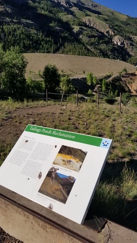
During its more than half century of operation, the Mayflower Mill created four major tailings ponds, two oldest and largest (No. 1 on the right, No. 2 on the left) are in the immediate foreground. Ponds No. 3 and No. . . . — — Map (db m177663) HM
From the eastern prairie to the Rocky Mountains and the western plateau country beyond, Colorado enjoys a rich abundance of wildlife. Protecting this heritage has been a challenge, and Colorado's success is due to the efforts and cooperation of . . . — — Map (db m47323) HM
For thousands of years, these grasslands have supported tens of millions of buffalo, from the giant species of ancient times to the smaller version of today. As North America's largest land animal, buffalo dominated life on the Great Plains. In . . . — — Map (db m47319) HM
The semi-arid plains are home to hundreds of wildlife species. but even species specialty adapted for life on the prairie need water to survive. The South Platte River and nearby State Wildlife Areas provide excellent habitat for a variety of wild . . . — — Map (db m47373) HM
Pre-Mining Landscape
This valley once held beaver ponds, wet meadows, shrub thickets and open grasslands. Fires started by Native Americans supported herds of mountain bison and favored growth of grasses and wildflowers on the valley floor. . . . — — Map (db m58592) HM
This family circle of fossilized redwood stumps grew out of the single trunk of an older parent tree. The three trunks are ancient clones, or genetically identical copies, of that parent tree. Modern coastal redwoods also reproduce by stump . . . — — Map (db m240610) HM
The Rocky Mountain region was much warmer 34 million years ago. The Florissant valley was forested with towering redwoods, false cypresses, pines, mixed hardwoods, and ferns surrounded by drier slopes with scrublands, shrubs, and low trees. . . . — — Map (db m158385) HM
Within a few steps is the transition from a dry meadow into a cooler forest of Douglas-fir, spruce, and common juniper. The moisture content is higher here. Though you're looking south, you are standing on a north-facing slope. North-facing slopes . . . — — Map (db m158502) HM
Standing here 34 million years ago you would probably recognize a number of plants and insects. But the year-round mild climate in the Rockies would be a surprise, as would the mammals of the time. The warm temperate forest was diverse, with . . . — — Map (db m158429) HM
As outcrops of shale weather, they separate into paper-thin sheets, exposing fossils on their surfaces. Within these delicate pages, a chapter of Earth's history unfolds.
Size played a key role in determining what was preserved at Florissant. The . . . — — Map (db m158439) HM
Open stands of ponderosa pine, Douglas fir, and quaking aspen now dominate the slopes of the Florissant valley. The ecosystem has changed since the days of the dense redwood forests. There are more open grasslands and the cold temperate forest is . . . — — Map (db m158433) HM
The three trunks of the Trio are all interconnected because they are part of the same tree! They were likely sprouts from a broken central tree, which makes them clones. The original rock matrix that buried the Trio in the late Eocene was excavated . . . — — Map (db m240476) HM
"One of the wonders of this part of the world is the 'Petrified Forest'...between Colorado Springs and Fairplay. This remarkable relic...bids fair to disappear very shortly, unless the...tourists cease their work of destruction. Everyone must . . . — — Map (db m158483) HM
To uncover the geologic history of the Florissant region, you must peel back the surface and examine the rock layers below. Sediments are deposited layer upon layer, with the oldest at the bottom and the youngest on top. Because of this principle . . . — — Map (db m158482) HM
The Abert's squirrel inhabits this forest. It eats ponderosa pine cones and the inner bark of the twigs. It's just one of many animals that depend on the ponderosa forest for food, nesting, and cover. The fossil record also shows animals and plant . . . — — Map (db m158510) HM
Pikes Peak is the huge mountain you see across the valley. On a clear day, you can see two distinct areas on the mountain—a darker band of forest and a lighter colored treeless area. These different layers called "life zones" are a . . . — — Map (db m158493) HM
A grassroots effort
Beneath this valley is one of the richest fossil deposits in the world. Imagine instead this valley filled with a housing subdivision. There would be no open space, no trails, no scientific research, and no . . . — — Map (db m158376) HM
Core samples from Sequoia affinis fossil stumps contain remarkably well-preserved annual growth rings. Locked within those concentric rings are clues about past growing conditions in the Florissant valley.
The stumps at Florissant have . . . — — Map (db m158428) HM
In the late Eocene epoch, about 34 million years ago, the Florissant valley was buried by eruptions from a cluster of volcanoes known as the Guffey volcanic center. Huge volcanic mudflows (lahars) spread into this forested valley with great speed, . . . — — Map (db m158402) HM
Just beyond the circular wooden fence in front of you is a young ponderosa pine tree growing out of the top of an ancient petrified redwood tree stump. The huge redwood tree was buried by a volcanic mudflow and was later exposed by erosion. The . . . — — Map (db m158515) HM
Can you see the spiral scar on the ponderosa pine directly to your right? It goes all the way up and around the tree. Lightning struck this tree many years ago. Lightning and the fires it causes are natural processes in forests like this one. Fire . . . — — Map (db m158506) HM
You are standing in the Florissant valley surrounded by ponderosa pine forests. But 34-35 million years ago, this was the site of Lake Florissant. The twelve-mile-long lake was formed when volcanic mudflows dammed a stream that flowed south . . . — — Map (db m158489) HM
Florissant Fossil Beds National Monument safeguards a buried treasure: one of the world's richest fossil deposits. Look around. This 6,000 acre open space belongs to all of us—and to future generations. But what if instead of a public resource, it . . . — — Map (db m240551) HM
You can help the Peak’s wild animals by not feeding them. “Can one chip hurt?” you may wonder. Yes it can, when multiplied by 2,000 visitors per summer day. Then when the summer’s over, the animals are without their junk food fix.
Even . . . — — Map (db m45844) HM
124 entries matched your criteria. Entries 101 through 124 are listed above. ⊲ Previous 100