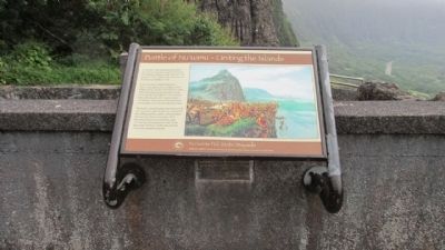
On Nuuanu Pali Drive, on the left when traveling north.
In the late 1700s, Kamehameha I from the island of Hawai’i, sought to unite all the Hawaiian islands under one rule. The battle for O’ahu began with the arrival of his forces at Waikiki in 1795.
O’ahu had been defeated by Maui forces a decade . . . — — Map (db m73557) HM
On Nuuanu Pali Drive north of Pali Highway (Hawaii Route 61), on the right when traveling north.
An International Soaring Record was established here on December 18, 1931. William A. Cocke Jr. remained aloft in a glider called the Nighthawk for 21 hours 34 minutes, a new U.S. and world endurance record for motorless fight.
Cocke’s . . . — — Map (db m156376) HM
On Nuuanu Pali Drive, on the left when traveling north.
Constructed in 1897 and opened for the public traffic in 1898. The road has an average grade of eight percent and is 8800 feet long. The original survey was made by John H. Wilson under supervision of William E. Rowell Superintendent of Public . . . — — Map (db m73555) HM
On Nuuanu Pali Drive, on the right when traveling north.
In the early 1800s, you had two choices if you wanted to travel between Honolulu and Windward O’ahu.
You could take a canoe trip around the southern end of the island or hike over the steep cliffs of the Ko’olau mountains. The pali (cliff) . . . — — Map (db m73554) HM
On Diamond Head Rd, on the right when traveling east.
The Hawaiian goddess Hi’iaka compared the
peak of volcanic cone of Diamond Head to the
dorsal fin of the ‘ahi fish, thus the Hawaiian name
for Diamond Head is Le’ahi.
This site was once the Dillingham Home, the
beachfront house of Harold . . . — — Map (db m111326) HM
On Diamond Head Rd, on the right when traveling north.
The Diamond Head Lighthouse is a prominent symbol of Hawaiian
history to residents and visitors alike.
The lighthouse rests aside a tuff-cone volcano, formed by
explosive eruptions thousands of years ago.
In 1825, British sailors ascended the . . . — — Map (db m111324) HM
On this site stood the villa of Chun Afong, Hawai‘i’s first Chinese millionaire, who arrived
in Honolulu in 1849. By 1855, he had made his fortune in retailing, real estate, sugar and rice, and for a long time held the government monopoly opium . . . — — Map (db m49676) HM
Olympic swimming champion Duke Kahanamoku (1890–1986) spent much of his youth here in Kālia with his mother’s family, the Paoas. The family owned most of the 20 acres which the Hilton Hawaiian Village now occupies.
It is said that it was . . . — — Map (db m13188) HM
On Kalakaua Avenue, on the left when traveling west.
Raised in Waikiki, Duke was a full blooded Hawaiian, who symbolized Hawai'i to millions of people. He developed into an Olympic Champion and the world's fastest swimmer. Between 1912 and 1932 he won three gold medals, two silver and a bronze in four . . . — — Map (db m73257) HM
On Ala Moana Boulevard at Kalakaua Avenue and Pau Street, on the right when traveling west on Ala Moana Boulevard.
This green expanse in the middle of Waikīkī is Fort DeRussy, named in honor of Brigadier General Rene E. DeRussy, Corps of Engineers, who
served with distinction in the American—British War of 1812. It was started in 1908
as vital . . . — — Map (db m13219) HM
Surrounded by this open landscape, one can imagine the huge coconut grove known as Helumoa. Planted by Chief Kakuhihewa around the 15th century, the grove once had nearly 10,000 trees. Kahuamokomoki was an area nearby that served as a sporting . . . — — Map (db m73416) HM
Operated by a crew of three protected by only 1/2 inch of armor and equipped with one 37mm gun and two 7.7mm machine guns. It was powered by a 6-cylinder, 110 H.P. air-cooled diesel engine with a range of 90-100 miles at speeds up to 30 MPH. — — Map (db m82123) WM
A light-weight mobile piece used by independent antitank and armored units. Its 3 lb. shell could penetrate 3 inches of armor at 500 yards. — — Map (db m82127) WM
Near Holomoana Street south of Ala Moana Boulevard.
Fish were easily netted from the ponds near Pi‘inaio Stream.
In ancient times, the
area was home to many Hawaiian families, who enjoyed the offerings in its bountiful waters. It was not unusual to see native men and women fishing, . . . — — Map (db m13127) HM
On Ala Moana Boulevard (Hawaii Route 92) at Kalia Road, on the right on Ala Moana Boulevard.
Envisioned on a grand scale, these three awe-inspiring figures in bronze are dancing hula kahiko, the ancient style of Hawaiian dance. The two female dancers, spirits of the wind, represent the dance and chant of Hawaiian hula. . . . — — Map (db m71922) HM
Had you walked across this road in 1897 you might have landed in Waikĩkĩ’s largest fishpond, the Ka’ihikapu, which measured 13 acres. All of today’s Fort DeRussy on the mauka (toward the mountain) side of the road was covered with . . . — — Map (db m73113) HM
From olden times Waikīkī was viewed not only as a place of peace and hospitality, but of healing.
There was great mana (spiritual power) in Waikīkī. Powerful kahuna la‘au lapa‘au (or physicians) lived here. Throughout the . . . — — Map (db m13225) HM
On Kalia Road at Maluhia Road, on the left when traveling south on Kalia Road.
Named in honor of Staff Sergeant Robert T. Kuroda, 442nd Regimental Combat Team.
On 20 October 1944, during the battle of Bruyeres, France, Sergeant Kuroda led his squad in an attack against a strongly defended enemy position. He deployed . . . — — Map (db m13256) HM
This cannon was one of a battery of twelve guns placed on punchbowl crater by the Hawaiian monarchy beginning in 1831. Both to defend Honolulu Harbor and to fire salutes. The U.S. Army moved the cannon to Bishop Museum in 1920, where it remained . . . — — Map (db m82128) HM
On Kalakaua Avenue, on the left when traveling west.
Prince Jonah Kuhio Kalaniana’ole, the son of High Chiefess Kekaulike Kinoiki II and High Chief David Kahalepouli Pi’ikoi, was born on March 26, 1871 at Ho’ai, Kaua’i. His mother died soon after his birth and he and his two older brothers were hanai . . . — — Map (db m73117) HM
Near Ala Moana Boulevard (Hawaii Route 92) at Kalia Road.
This Rainbow Mural, tallest in the world, 286 feet high, 26 feet wide, comprises 8,046 pieces of hand-painted ceramic tile created for the Hilton Tower by Millard Sheets. Dedicated by Conrad N. Hilton and Fritz B. Burns. November 8, 1968. — — Map (db m19077) HM
Near Holomoana Street south of Ala Moana Boulevard.
The legendary surfer Duke Kahanamoku often strolled the sands of Waikīkī Beach fronting what is now Hilton Hawaiian Village Beach Resort & Spa, 1959.
In ancient times, the coastal plain where you now stand was known as . . . — — Map (db m13082) HM
On Kalaukaua Ave, on the left when traveling west.
Princess Lili’uokalani enjoyed spending time with Robert Louis Stevenson on Waikiki in “earnest conversation”, Feb 3, 1889
This section of Waikiki Beach contains four distinct areas: Outrigger Canoe Club, San Souci, Kapi’olani Park and Queen’s . . . — — Map (db m73122) HM
On Kalakaua Avenue, on the right when traveling north.
The Moana Hotel opened on March 11, 1901 as Waikiki’s first hotel. Affectionately called “The First Lady of Waikiki,” this iconic resort embraces true Hawaiian hospitality. Walter Chamberlain Peacock, the original owner of the Moana . . . — — Map (db m73114) HM
On Kalaukaua Ave, on the left when traveling west.
Legend says these stones are the living legacy of four powerful Tahitian healers who once resided near this site at a place called Ulukon. From the court of the Tahitian chief, the names of the four were Kapaemahu, Kapuani, Kinohi, and Kahaloa. . . . — — Map (db m73116) HM
On Ala Moana Boulevard (Hawaii Route 92) at Kalia Road, on the right on Ala Moana Boulevard.
Chief Ma‘likūkāhi, who reigned over the island of Oahu in the mid-1400s, resided in Waikīkī and used it as his seat of government. He was greatly loved by his subjects who enjoyed unprecedented peace and prosperity. Ali‘i . . . — — Map (db m13200) HM
With the emergence of airborne troops in 1941 came the need for an airborne howitzer. The M3 was created by shortening an existing 105mm howitzer barrel and mounting it on a modified 75mm carriage. The lightweight M3 proved to be an effective weapon . . . — — Map (db m82125) WM
Used for scouting and reconnaissance in the late days of WWII. It mounted a 75mm main gun and three machine guns behind 1" of armor. Two Cadillac V-8 engines drove the 19 ton tank and its crew of four at speeds up to 35 MPH. — — Map (db m82124) WM
In the months before Dec 7th, many of these steel pillboxes were planted to defend military installations, airfields, and likely landing beaches around Oahu. Once buried in position, the 2-man crew entered through culvert pipe openings at the base . . . — — Map (db m82121) WM
Born to Chiefess Miriam Kapili Likelike (sister to King Kalākaua and Queen Lili’uokalani) and Governor Archibald Scott Cleghorn. She was the only child born to the last ruling dynasty of the Hawaiian Kingdom.
Princess Ka’iulani and her . . . — — Map (db m73229) HM
On Kalaukaua Ave, on the left when traveling west.
Waikiki means “spouting water” because it was a vast marshland fed by many streams. You are in fact standing on what was the mouth of an old stream, the Kuekaunahi. From ancient times Waikiki has been a popular surfing spot which is one of the . . . — — Map (db m73119) HM
On Kalakaua Avenue north of Saratoga Road, on the right when traveling south.
Honoring the World War II Veterans of the 100th Infantry Battalion (Separate), the 442nd Regimental Combat Team, the Military Intelligence Service, and the 1399th Engineer Construction Battalion.
“Veterans who served in these units, . . . — — Map (db m26939) HM
On Kalakalua Avenue at Kukio Avenue and Kuamoo Street, on the left when traveling south on Kalakalua Avenue.
(tablet on back of base)
David Kalākaua was born on November 16, 1836. He succeeded to the throne on February 12, 1874, and ruled with his queen, Kapi‘olani. King Kalākaua was the catalyst for the revival and flowering of . . . — — Map (db m13586) HM
On Kalia Road at Lewers Street, on the left when traveling north on Kalia Road.
Ancient Hawaii was governed by a sharply defined caste system. The kings were the highest authority. Chiefs, or Alii, ruled over sections of the land at the pleasure of the kings. At times there was a king for each of the major islands in the . . . — — Map (db m75626) HM