On Penn Avenue (U.S. 422) at Elm Street, on the left when traveling west on Penn Avenue.
This property has been
placed on the
National Register
of Historic Places
by the United States
Department of the Interior
———————
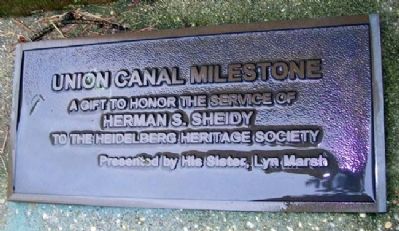
Union Canal Milestone
A gift to honor the . . . — — Map (db m39322) HM
On Benjamin Franklin Highway (U.S. 422) 0.2 miles west of Limekiln Road, on the right when traveling east.
On his first visit to America
1682 - 1684
came farthest north
on Schuylkill River
fifty miles up
from the Falls of Schuylkill
to or near the mouth of Monocacy Creek
three fourth of a mile
south-[direction erased] of this marker . . . — — Map (db m25202) HM
This tablet is in commemoration of the services of Revolutionary War soldiers buried in Hain's Church (St. John's Reformed) Cemetery at Wernersville, Pa. This tablet is dedicated in grateful recognition of their patriotism and valor.
[Honor . . . — — Map (db m39299) WM
On Philadelphia Avenue (Pennsylvania Route 724) at Shilling Street, on the right when traveling west on Philadelphia Avenue.
Two-time Pulitzer Prize winner and one of
America's most noted authors, Updike lived
here until age thirteen. He was inspired
by his mother, an amateur writer, and his
childhood surroundings, which he included
in many works over his 50-year . . . — — Map (db m242030) HM
On Bellemans Church Road just west of North Riverside Drive, on the right when traveling west.
Berks County authorized construction of the Dauberville Bridge, built on this site in 1908. This was one of the earliest examples of concrete bridge construction in Pennsylvania. As constructed, the arches, each spanning seventy-five feet, the four . . . — — Map (db m161050) HM
On Perkiomen Avenue (U.S. 422) west of Lincoln Road, on the right when traveling east.
President Lincoln’s great-great grand-father Mordecai purchased Andrew Robeson’s land and built the stone house that stands about 1¼ miles south of here in 1733. Mordecai Lincoln served as Justice of the Peace of Philadelphia County from 1733 to . . . — — Map (db m296062) HM
On Schuylkill River Trail 0.2 miles east of Brentwood Drive, on the left when traveling east.
Birth of Berks County
Settlement began with the Lenni-Lenape of the Delaware Nation. In 1681 William Penn founded Pennsylvania and in 1748 his sons Thomas and Richard established Readingtown. It became the county seat when Berks County was . . . — — Map (db m160558) HM
On Boulevard of the Allies at Market Street, on the right when traveling east on Boulevard of the Allies.
Pioneering editor and publisher who issued first edition of Pittsburgh Gazette, 1786. First newspaper west of Alleghenies, it became the Post-Gazette, 1927. A Berks County native, he was active in Western Pennsylvania's civic affairs; home and print . . . — — Map (db m42024) HM
On Old Philadelphia Pike at Britton Street on Old Philadelphia Pike.
A Wayside Inn
The first innkeepers on the White Horse tract were Swedish settler Marcus Huling and his wife, Margareta, a daughter of Mouns and Ingeborg Jones, the area's earliest European settlers. The Hulings' inn was established in the . . . — — Map (db m160503) HM
On Penn Street at South 2nd Street, on the right when traveling east on Penn Street.
Laid out 1748 by direction of Thomas Penn. Seat of Berks County since 1752. Incorporated borough, 1783. Soon became, and has remained, center of the Pennsylvania-Dutch area. An old and progressive industrial community. — — Map (db m161067) HM
On East Lancaster Avenue (US 222) at Mifflin Blvd. on East Lancaster Avenue (US 222).
Member of the Continental Congress, a Revolutionary soldier, first Pennsylvania governor, 1790-99, lived at his estate Angelica from 1774 to 1794. The Berks County Farm and Home now occupies the site. — — Map (db m84488) HM
Governor of Pennsylvania, 1835-1839, lies buried in this cemetery. Born, 1780, in Berks County; died, 1869, at Carlisle. He was noted for having put into practical operation the law of 1834, which established the public school system. — — Map (db m84038) HM
On North Krocks Road 0.1 miles Fred Jaindl Memorial Highway (U.S. 222), on the right when traveling south.
Railroads
Railroads came early to the Lehigh Valley for only one reason: anthracite coal. For iron to be smelted productively in the modern furnaces of the 1840s on, enormous amounts of coal needed to be brought to the furnaces. The ore . . . — — Map (db m252229) HM
On North Krocks Road 0.1 miles south of Fred Jaindl Memorial Highway (U.S. 222), on the right when traveling north.
Barns in this area, with their distinctive decorations, are widely admired. Nowhere else can you find as many fine barns of the type known as "Pennsylvania standard" barns. Their signature features are symmetrical rooflines and a forebay that . . . — — Map (db m252166) HM
Near Hamilton Boulevard east of North Krocks Road, on the right when traveling west.
William Penn's 1681 charter from King Charles II of England authorized Penn to create counties and towns or townships in Pennsylvania. Philadelphia, Bucks, and Chester, all created in 1682, were the first three counties. If you were standing on . . . — — Map (db m252211) HM
On Kentucky Route 313 at Doe Run Inn Road, on the left when traveling south on Kentucky Route 313.
Listed on the National Register of Historic Places. Creek discovered by Squire Boone and John McKinney, 1778. District includes one of oldest mills in Ky., built before 1792 by Jonathan Essery. Mill operated until 1900 when converted to resort; . . . — — Map (db m204283) HM
The Port of Reading was one of a number of major inland port towns located along the navigable waterways in Pennsylvania. It was at Reading that the Union Canal joined with the Schuylkill Navigation System. The Union Canal extended along the . . . — — Map (db m84491) HM
On North Main Street south of West Central Street, on the right when traveling south.
Philip Gunckel, along with three other men, led a group of settlers from Berks County, Pennsylvania to Ohio and founded Germantown in 1804. In 1814 he platted out 32 acres. The historic buildings and unique alley system in the eight and one half . . . — — Map (db m229192) HM
On Coulter Road 0.2 miles north of Biddle Road, on the left when traveling north.
Andreas Gerberich arrived at port of Philadelphia from the parish of Michelreith, Lower Franconia, Bavaria, October 1, 1754. Settling near his brothers in Tulpehocken Township, Berks County, Pennsylvania, Andreas married Barbara Babb in 1758. . . . — — Map (db m262032) HM
Near Parkside Drive South 0.2 miles west of Museum Road, on the right when traveling west.
Lenni Lenape: The Original People
Thousands of years before the first Europeans arrived in Northern America. North American Indians known as Lenni Lenape occupied parts of New Jersey, Delaware, and Pennsylvania, including Reading and Berks . . . — — Map (db m161109) HM
Near River Road at Ashbourne Drive, on the left when traveling west.
The First Settlers
The Lenni-Lenape, or "original people", were the first to inhabit the banks of Ganshowahanna, or "falling waters", their name for the Schuylkill River. The Lenni-Lenapes in this area were members of the peaceful tribes . . . — — Map (db m161131) HM
On Pinch Road 0.1 miles south of 4th Street, on the right when traveling north.
Situated about a mile up this footpath is Governor Dick. There stands a monolithic observation tower of reinforced concrete and steel. Fifteen feet in diameter and sixty-six feet high. From it is visible a wondrous view of the picturesque Mt. . . . — — Map (db m286492) HM
Near Old Philadelphia Pike 0.1 miles north of Britton Street, on the left when traveling north.
Oldest Documented House in Berks County
Mans Jonasson (1663-1727) was descended from Swedes who settled in present day Philadelphia, along with the lower Delaware and Schuylkill Rivers, in 1638. Later known as Mouns Jones he was the first . . . — — Map (db m160529) HM
On Tulpehocken Road at Red Bridge Road, on the right when traveling south on Tulpehocken Road.
At one time there were thirty-seven covered bridges throughout Berks County. Today the Wertz's covered Red Bridge is one of only five that remain. It was built in 1867 by Amandas Knerr for $7,450.
The "Red” Bridge is the longest single span . . . — — Map (db m208711) HM
Near Frontier Drive north of Barterbrook Road, on the right when traveling north.
Settling the Valley
Colonial authorities encouraged Protestant immigrants to move to the Valley of Virginia starting in the 1720s and 1730s. Over the next decades, mostly Ulster Scot, German, English, and Virginian settlers established . . . — — Map (db m298905) HM
Near Minuteman Parkway at West Frankfort Connector.
A legend in his own lifetime, Daniel Boone was an explorer and hunter whose exploits made him one of the most famous frontiersmen in American history. One of 11 children raised in a Quaker household, he was born on November 2, 1734, in Berks County . . . — — Map (db m161763) HM
On State Highway F 0.1 miles south of Boone Ridge Trail, on the right when traveling south.
Who was Daniel Boone?
Many picture Daniel Boone as a famous Kentucky pioneer and hunter. While this was certainly true, Boone participated in many other ventures throughout his long life. He was a blacksmith, land surveyor, business . . . — — Map (db m169496) HM
On Front Street north of State Street (Old U.S. Highway 22), on the left when traveling north.
Martin Kaercher Sr. from Germany purchased 250 acres of land called "Hamburg" in 1772. Its natural wonders made it an ideal area for agriculture and farming. Because of this attribute, "milling" is a prevalent theme in the region's history, . . . — — Map (db m138471) HM
Thin black lines indicate changes in relevance. Between each pair of lines entries are ordered geographically but all have the same relevance.
* Inflectional forms of words are their plurals, singulars, and possessives as well as gramatical tenses and similar variations.