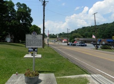
On Dayton Pike north of Mountain Road (County Road 1126), on the right when traveling north.
Hasten Poe, a veteran of the War of 1812, moved from Virginia and built a log structure on this site in 1818. The area became known as Poe’s Cross Roads, later Daisy and in 1969 Soddy Daisy. The structure was used as a tavern and inn. On October 25, . . . — — Map (db m74853) HM
On Georgia Avenue just north of East 7th Street, on the left when traveling north.
Hamilton County
created October 25, 1819, named for
Alexander Hamilton
born January 11, 1757; died July 12 1804. Aide de Camp to
Gen. Washington at twenty: member of Continental Congress at
twenty-five; captain in Revolutionary War; a leader in . . . — — Map (db m150512) HM
On Main Street (U.S. 64/72) at Betsy Pack Drive (U.S. 41), on the right when traveling west on Main Street.
In recognition of the rare vision, the indomitable courage and capacity of achievement of Will Cummings, county judge of Hamilton County, the pioneer of permanent road building and public improvements in east Tennessee and the Chattanooga district, . . . — — Map (db m39437) HM
On Broad Street at St Elmo Avenue, on the right when traveling north on Broad Street.
In recognition of the rare vision, the indomitable courage and capacity of achievement of Will Cummings, county judge of Hamilton County, the pioneer of permanent road building and public improvements in east Tennessee and the Chattanooga district, . . . — — Map (db m28769) HM
Near Riverfront Parkway, on the right when traveling west.
Once a ferry crossing connecting the worlds of the Native American Cherokee and the Anglo-American settler, Ross's Landing was the heart of the town of Chattanooga.
This place was once a river crossing known as Ross's Landing. John Ross, an . . . — — Map (db m184223) HM
Near Champion Road 0.1 miles south of Blue Oak Drive, on the right when traveling south.
Few men have the satisfaction of knowing they have made a contribution in their lifetime that will last through the ages and touch the lives of millions.
Men of the CCC know that feeling well. The Civilian Conservation Corps was launched April . . . — — Map (db m167750) HM
On Summit Street, on the right when traveling north.
Civil War
Brown, Wilson, W. Co. F, 21st Ohio Infantry, Private, Army. Born; December 25, 1837 in Logan County, Ohio. Entered service in Wood County, Ohio. Died; December 25th, 1916, in Toledo, Ohio. Buried at New Belleville Ridge Cemetery, . . . — — Map (db m160385) WM
[The Ed Johnson Memorial consists of nine plaques. From left to right, they are:]
Chattanooga in 1906
Chattanooga was a prominent industrial center of the New South in the early 20th century. The city's growth in the . . . — — Map (db m254357) HM
On March 7, 1867, the Tennessee River began to rise at the rate of one foot per hour. Chattanooga experienced floods every spring, but this one, later known at the Great Flood, continued to rise until March 11, when the waters crested 57.9 feet . . . — — Map (db m266493) HM
On 8th Street at Douglas Street, on the right when traveling east on 8th Street.
Dr. Emma Rochelle Wheeler, a graduate of Meharry Medical College, established, owned and operated Walden Hospital beginning in 1915. Established to serve the medical needs of Chattanooga's Negro community, the hospital had a 30-bed capacity. Walden . . . — — Map (db m13932) HM
Near Walnut Street north of East Aquarium Way, on the right when traveling north.
As the conflict between the North and South became more intense, many residents of Chattanooga had mixed sympathies. The town was obviously in the South, but further economic growth could only come as a result of increased trade with the North. . . . — — Map (db m254495) HM
On U.S. 41/129 just south of Chan Bridge Drive (15th Avenue Northwest), on the left when traveling south.
Warren Alford — US Army • Jack A. Buckles — US Army • Booker T. Bryant Jr. — US Army • Willie F. Cato — US Army • Arlester Cole — US Army • James A. Eatmon — US Navy • Joseph W. Goodbread — US Army • Obie R. Harris — US Navy • Dwight M. Hewitt — US . . . — — Map (db m234507) HM WM
From the time the Tennessee Valley was first inhabited over 10,000 years ago, the Tennessee River and its tributaries have been a vital source of transportation, communication and trade. When regular contact between Europeans and Cherokees became . . . — — Map (db m254493) HM
On Baker and Hearn Circle 0.6 miles south of Cove Road (Georgia Route 341), on the right when traveling south.
Bird's Mill was built on West Chickamauga Creek during the 1840's by Philemon Bird, a member of a prominent and wealthy Georgia family. The mill was constructed well away from the creek on a long mill race that was dug by hand to bring the water . . . — — Map (db m168205) HM
On Dodds Avenue (U.S. 64) north of Burkett-Miller Drive (Route 0), on the right when traveling north.
From 1908 to 1969, this was the site of the first Hamilton County high school to offer a
full four-year curriculum. From an initial graduating class of 19, the school grew to an
enrollment of approximately 2000 students, making it one of the . . . — — Map (db m153761) HM
On Dayton Pike at Boyd Street, on the left when traveling north on Dayton Pike.
A veteran of the War of 1812, Hasten Poe came to the area now known as Soddy Daisy to claim his 600 acre land grant. He built an inn and tavern at the crossroads of Washington Pike and Sequatchie-Dallas Trail. In 1818 he and others met at Poe's . . . — — Map (db m300356) HM
On North Avenue G south of East Cypress Stret, on the right when traveling north.
James Franklin Barnwell was born on October 23, 1874 in Bowdon, Georgia. His family had a tradition of doctors, including his grandfather and three uncles. Following completion of his medical education at the University of Tennessee in 1896, . . . — — Map (db m126759) HM
On Pecan Street at North Railroad Street, in the median on Pecan Street.
John Rankin Alford was born in Tennessee in 1834, and he arrived in Hamilton County, Texas, in 1860 with his wife Martha Ann (Malone). The couple settled on Honey Creek and Alford began selling goods that he had brought with him by wagon and also . . . — — Map (db m177613) HM
On J Lon Foust Highway / Rhea County Highway (U.S. 27 at milepost 0), 0.6 miles south of Old Graysville Road (State Route 303), on the right when traveling north.
Rhea County
Established 1807; named in honor of
John Rhea
Revolutionary veteran, who fought at King's Mountain. Delegate to the North Carolina Convention which ratified the U.S. Constitution; member of the Tennessee Constitutional . . . — — Map (db m26017) HM