Panel 1:
Formerly a Nike Missile control site, U.S. Army 1956-1968.
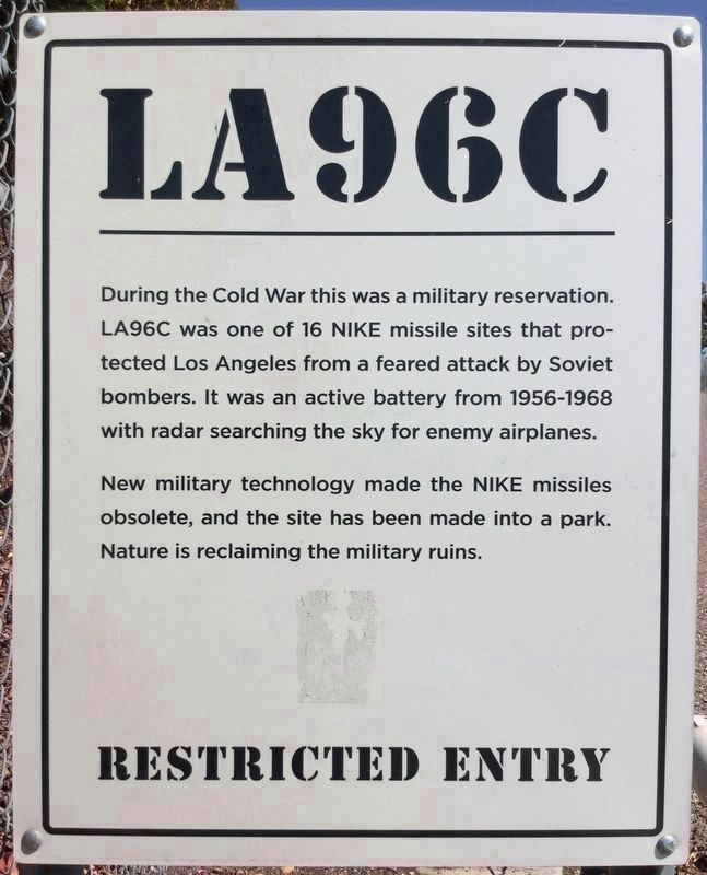
Currently San Vicente Mountain Park, gateway to the Big Wild.
Restricted entry, vehicles with handicapped permits only beyond this point.
Welcome.
Panel . . . — — Map (db m146037) HM
The large concrete bunker, seen
across the street, was the White Point
Nike Site, built in the early 1950's. It was
one of many such sites ringing the Los
Angeles basin manned by National Guard
units. Originally a site for the . . . — — Map (db m147323) HM
By 1945, the age of aerial warfare had fully arrived and the U.S. Army sought a weapon that could intercept enemy aircraft. In 1951, after years of research and development, a supersonic missile controlled by ground-based electronic equipment was . . . — — Map (db m102818) HM
Center Panel
Guardians of the Sky
Technological advances during World War II brought new threats to the Bay Area. Traditional weapons were useless against new, fast, high-flying jet planes. This need for better antiaircraft defense . . . — — Map (db m203629) HM
This multi-used path was formerly a railroad track, used over time by both passenger and freight trains. The building perpendicular to the street replaces an earlier structure, a barn/tobacco warehouse. Growers brought tobacco there to store until . . . — — Map (db m164126) HM
This park occupies seven parcels of land in Montgomery county used by the U. S. Army for the air defense of Washington D.C. from the mid-1950's to the mid-1970's
In the early days of the Cold War, the Soviet Union produced high-speed high-altitude . . . — — Map (db m61671) HM
The Cold War, extending from 1953 to 1979, introduced a heightened level of danger to the world. It was particularly worrisome to Americans, who experienced no homefront battles other than Pearl Harbor during the two world wars. The Cold War . . . — — Map (db m211132) HM
Aircraft changed the style of warfare forever, and by the end of World War II anti-aircraft guns had taken over the key defensive role at Fort Hancock. The Cold War era brought a change from anti-aircraft guns to supersonic radar guided air . . . — — Map (db m208234) HM
Missiles emerged from silos beneath the pavement, and waited on launching racks while radar tracked the skies. During the 1950’s – the Cold War Era – Nike missiles were stationed here to defend the New York-Philadelphia corridor against . . . — — Map (db m208236) HM
Missiles emerged from silos beneath the pavement, and waited on launching racks while radar tracked the skies. During the 1950’s – the Cold War Era – Nike missiles were stationed here to defend the New York-Philadelphia corridor against . . . — — Map (db m41714) HM
One of thirteen installations in the Philadelphia area that provided protection from Soviet aerial attack during the 1954–1970 period of the Cold War. The Nike system here used radar to guide Ajax anti-aircraft missiles. From the mid-1960s . . . — — Map (db m86028) HM
During the Cold War a ring of Nike anti-aircraft missile sites defended the nation’s capital, reminiscent of the perimeter of forts that protected it during the Civil War. Just east of here was located the launch control equipment for one of the . . . — — Map (db m2093) HM
Just to the southeast were radar and other control equipment that formed a portion of one of three Nike anti-aircraft missile complexes in Fairfax County. The site was operated by the U.S. Army between 1954 and 1962. Established during the Cold War . . . — — Map (db m2091) HM
Located north of here was one of three Nike anti-aircraft missile complexes in Fairfax County operated by the U.S. Army and the Army National Guard between 1954 and 1974. The sites were established during the Cold War to defend Washington from . . . — — Map (db m131374) HM
Nike Ajax Explosion Battery B. 526th Missile Battalion Leonardo, New Jersey In Memoriam 22 May 1958
Sgt. Daniel J. Lavengood •
Sgt. Jerome W. Mould •
SP3 Walter E. Berry •
SP3 William I. Cochran •
PFC Donald L. Marsh •
Pvt. Nicklos J. . . . — — Map (db m22642) HM WM
In 1954 Angel Island became one of nineteen Nike Missile sites in the Bay Area. There were three underground magazines, each storing 12 Nike – Ajax anti-aircraft missiles. The missiles had a range of 25 miles and were raised to the surface by . . . — — Map (db m203034) HM
Sandy Hook has been fortified to defend New York Harbor for more than two centuries – first by British Loyalists occupying the Sandy Hook Lighthouse during the American Revolution and the American troops constructed a wooden palisade fort during . . . — — Map (db m22645) HM
Explore Battery Alexander
Battery Alexander
Built in 1901, the concrete coastal defense installation in the grove of trees behind the restroom held mortars that could fire 12-inch diameter shells in a high arcing path to penetrate the . . . — — Map (db m232187) HM
Construction for this 70-bed hospital began in 1911. The hospital treated soldiers returning from overseas for discharge. In 1918, the hospital annex was added to care for men with lingering illnesses.
During the Nike Missile period . . . — — Map (db m69301) HM
Crile General Hospital, named for renowned Cleveland surgeon, Dr. George W. Crile, was dedicated at this site on April 21, 1944. Dr. Crile, founder of the Cleveland Clinic Foundation, was a brigadier general in the U.S. Army. The $4.5 million . . . — — Map (db m23924) HM
During the Civil War, the U.S. Army constructed a series of forts and artillery batteries around Washington to protect it from Confederate attack. Forts O’Rourke, Weed, Farnsworth, and Lyon stood just to the north, and Fort Willard which still . . . — — Map (db m2330) HM
Golden Gate National Recreation Area
From Roundups to Radar
A sprawling Mexican rancho, where vaqueros (cowboys) herded cattle, encompassed this valley and its surrounding hills during the mid-1800s. Cattle roundups on the beach . . . — — Map (db m232185) HM
The United States Air Force established its first radar at Montauk Point in 1948. In the years that followed, Montauk Air Force Station was home to a variety of surveillance and height-finding radar that guarded the New York City area . . . — — Map (db m140340) HM
For the first three-quarters of the 20th century, the Marin Headlands were fortified with weapons that evolved from cannon to nuclear warheads. The guns became more and more powerful, able to hit warships miles out to sea. Antiaircraft guns appeared . . . — — Map (db m102828) HM
History This park takes its name from the Civil War era fortress on the property. Originally referred to by its location on Willets Point, the Army officially named it for General Joseph Totten (1788-1864), following his demise in the . . . — — Map (db m65125) HM
The successor to the first Nike missile, the Nike "Ajax", the "Hercules" was a much more capable missile in every way. Designated as MIM-14 it came in three different models A/B/C and over 25,000 missiles were made with the most being the MIM-14B . . . — — Map (db m12584) HM
Listed in The National register of Historic Places: 1980
Barracks Building #22 is a contributing structure in the Fort Hancock and Sandy Hook Proving Ground National Historic District. Throughout its history, Fort Hancock played a major role . . . — — Map (db m36891) HM
History
This park takes its name from the Civil War era fortress on the property. Originally referred to by its location on Willets Point, the Army officially named it for General Joseph Totten (1788-1864), following his demise in the Battle of . . . — — Map (db m65126) HM
Located in the counties of Palo Pinto and Parker, Fort Wolters' history dates back to the days of "Old" Camp Wolters, created in 1925 as a National Guard training area under the guidance of General Jacob F. Wolters.
On October 13, 1940, the U. . . . — — Map (db m226028) HM
Welcome to Fort Story, home to a variety of U.S. Army and Navy units. The installation's 1,451 acres are presently used for training by the Army's 7th Sustainment Brigade, Naval Amphibious forces and Special Operations forces. The post also serves . . . — — Map (db m79242) HM
The Marine Mammal Center is built on the site of the former Nike Missile Launch Area, SF 87L. In the 1950s, the army constructed two batteries in the Marin Headlands equipped with surface-to-are missiles, one near Fort Cronkhite and a second across . . . — — Map (db m102832) HM
Travel along the Oregon and California trails increased in the 1840s with the cry of “Westward Ho.” When the 1848 discovery of gold was made at Sutter’s Mill in California, the desire to reach the gold fields ahead of others intensified . . . — — Map (db m131310) HM
This was once the site of an Army
anti-aircraft missile base, Battery C, 85th AA Guided Missile Battalion
which provided air defense to our
community from 1956 to 1962
This Nike Missile Dedicated
July 4, 1980
City of Riverview
Mayor: . . . — — Map (db m174881) HM
The eastern edge of downtown Milwaukee, the lakeshore itself, was very close to this spot until the early 20th century. If you were standing here before 1917 you would be standing very near the water’s edge. Between 1917 and 1937, Milwaukee filled . . . — — Map (db m56832) HM
Milwaukee's three rivers and surrounding wetlands first attracted Native Americans to the area. The water provided game, waterfowl, fish and wild rice. These waterways also provided transportation routes for their canoes and dugouts that carried . . . — — Map (db m147639) HM
Juan Rodriquez Cabrillo, exploring for Spain, discovered Alta California and named San Pedro Bay, “Bahia de los Fumos” (Bay of Smokes), October 1542. The smoke on the Bay shore came from the native Suang-Na Indian Fires. Sebastian . . . — — Map (db m127129) HM
Here, at a former Nike missile site, the U.S. Army
Map Service established a research station to
support geo-location and navigation in 1961. Two
years later, the Map Service Initiated a significant
satellite tracking program that became part . . . — — Map (db m104755) HM
Evolution of a Landscape – Plantation, Prison, Park
It may be difficult to imagine all of the events, large and small, that took place on the surrounding landscape, but Laurel Hill Park has been influenced by thousands of years of . . . — — Map (db m22385) HM
Center Panel
Bustling Army Post
Picture this spot a century ago. You can hear raised voices and the crunch of boots as soldiers drill. The smell of dinner wafts through the air. It’s hard to see the end of the mess hall line.
Fort . . . — — Map (db m203620) HM
Revolutionary War
Clinton County did not exist when the Revolutionary War was fought, but it was the brave veterans of that war who settled this area of Ohio. Short on cash, our young country paid her soldiers with land grants in the newly . . . — — Map (db m214753) WM
* Inflectional forms of words are their plurals, singulars, and possessives as well as gramatical tenses and similar variations.