On The Escort Way (Highway 81) at Orange Road (Highway 90), on the right when traveling west on The Escort Way.
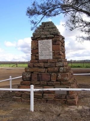
From this vicinity Sir Thomas Mitchell's second expedition proceeded on April 7, 1835 to the Darling River, his third expedition on March 19, 1836 to Australia Felix (Western Victoria), and his fourth expedition on December 15, 1845 to Tropical . . . — — Map (db m38374) HM
On Virgil Street, on the right when traveling south.
The old town of Gungafai was built on the flats where these bridges now cross. The town was first gazetted and surveyed in 1838. The town flooded about 1 metre in 1844 and 1851.
On the 25th June 1852 the old town was destroyed by a flood 4 to . . . — — Map (db m71067) HM
On Argyle Street west of Harrington Street, on the right when traveling west.
Captain Stanley Savige formed Legacy in 1923, as an offshoot of the Remembrance Club founded by Major General Sir John Gellibrand to help former servicemen struggling to re-establish themselves after World War I.
The Legacy Club changed its . . . — — Map (db m126551) HM
Whales (generally humpback or southern-right) can provide a magnificent spectacle off this coastline during their annual migration south, from September to November.
Many long-time residents of Tuross Head can recall the arrival of a whale on . . . — — Map (db m38375) HM
Near Chifley Road, 0.1 kilometers east of Petra Avenue.
A railway zig zag is a series of reversing ramps used to avoid very steep grades. John Whitton, Engineer in Chief NSW Government Railways 1856-90, chose this as the economical method for the descent from Clarence to Lithgow. Built during 1866-69 by . . . — — Map (db m59808) HM
On Swan Street at Berkeley Street, on the right when traveling west on Swan Street.
This historic Bakehouse was built by Richard Chapman during 1851. Chapman was a property owner, butcher and businessman of Morpeth whose residency extended from at least 1850 to his death in 1867. The building has technical value as a rare, . . . — — Map (db m70687) HM
Near Marine Parade, on the left when traveling south.
From this lookout, formally attired spectors (sic) watch a surf carnival against a sweeping panorama of thriving pines. Today high-rise buildings dwarf the trees, which were damaged by airborne pollution from North Head sewage works. Since the . . . — — Map (db m70686) HM
This marker is made up of two panels placed back to back.
Cooma 1890
During the 1880s Cooma was expanding rapidly and Sharp Street had become the town’s main thoroughfare, although settlement was still quite scattered. Some very . . . — — Map (db m70674) HM
On Lambie Street (New South Wales Route B72) at Sharp Street, on the right when traveling east on Lambie Street.
This marker consists of two plaques placed back to back.
In the 1850s Cooma was developing in two areas, one around Lambie and Mulach Street, the other over the hill where Centennial Park and Sharp Street are now. Nevertheless for the . . . — — Map (db m70675) HM
On Batlow-Tumbarumba Road at Old Tumbarumba Road, on the right when traveling south on Batlow-Tumbarumba Road.
The White Gate was a well-known landmark last century. By 1910 it was old and lying beside the posts which were still standing. The original White Gate was erected at the junction of the Batlow-Tumbarumba and Old Tumbarumba roads, marking the . . . — — Map (db m95910) HM
Near Mrs Macquaries Road, on the left when traveling north.
Don't miss this notable landmark — Mrs Macquaries Chair is just around the corner to your right. It is actually a carved rock ledge seat where Elizabeth Macquarie, the Governor's wife, liked to sit and admire the view of the harbour. Her husband had . . . — — Map (db m185648) HM
This plaque commemorates the 200th anniversary of the birth of
Captain Matthew Flinders R.N. at Donington, England. On 16th March, 1774
Captain Flinders was the first person to circumnavigate this continent and
was largely responsible for the use . . . — — Map (db m245311) HM
On Peel Street just north of Darling Street, on the right when traveling south.
Tamworth N.S.W. was the first town in Australia to introduce electric street lighting by means of two 18kw steam driven Crompton dynamos. Electricity was supplied to 52 street lights using 140 Swan incandescent lamps and 7 Crompton carbon arc lamps. . . . — — Map (db m70695) HM
On Marius Street close to Brisbane Street, on the right when traveling south.
For Australia
1962 – 1973
Their bodies are buried in peace and their names liveth for evermore
Killed in Action
From
Tamworth Region
213780 Pte Wilson M.A.F.
1 RAR 8 Jan 66
2781465 2 Lt Sharp G.C.
6 RAR 18 Aug 66 . . . — — Map (db m71048) WM
Stannum House
Built in 1888 “Stannum” Latin for tin, hence the owner, Mr. John Holmes Reid made the first of his fortune in tin mining.
Stannum is a Victorian-Italiante villa, triple brick, double airflow system with granite . . . — — Map (db m70697) HM
On Wickham Terrace at Bartley Street on Wickham Terrace.
The oldest surviving building in Queensland, the Windmill, was constructed by convicts in 1828 to grind flour and maize meal as food for the Moreton Bay Penal Settlement. A stone and brick building, it contained two pair of mill stones - one pair . . . — — Map (db m100365) HM
Plaza
The Man from Snowy River
The Man from Snowy River written by A. B. "Banjo" Paterson is Australia’s most epic ballad and first appeared in print on 26 April 1890.
Recounting the legendary exploit of an heroic mountain-man’s . . . — — Map (db m237077) HM
To honour the achievement of surveyor Francis Edward Roberts who in 1863-1866 surveyed the Queensland-New South Wales border over rugged and mountainous country for a distance of 215 miles from Point Danger.
This plaque was erected 1st. December . . . — — Map (db m245546) HM
This memorial
erected to commemorate the Centenary
of the landing at this spot of
Lieut Bowen, RN
on 13th September 1803,
was unveiled by His Excellency the Governor
Sir A. E. Havelock, G.C.S.I.,
G.C.M.G., G.C.I.E.
22nd February . . . — — Map (db m81891) HM
In memory of those who served
Boer War 1899-1902
World War I 1914-1918
World War II 1939-1945
Korea 1950-1953
Vietnam 1963-1972
Conflicts in Malaya, Borneo,
East Timor, Afghanistan, Iraq,
and all peacekeeping forces. . . . — — Map (db m135758) WM
The Lucas Platypus Experience is housed in a classified building on the register of the National Trust Estate. In 1858 George Atkinson built a licensed hotel “The Royal Charter Inn” on the present site. At the time he imported from Liverpool UK a . . . — — Map (db m70668) HM
Near Boland Street close to Willis Street, on the left when traveling west.
Lighting up Launceston
First established in 1858, the Launceston Gasworks charts the growth of the gas industry in Tasmania and the development of the city of Launceston itself.
The site was purchased in 1858 by the Launceston Gas . . . — — Map (db m70667) HM
On Dog Netting Road, on the right when traveling north.
This plaque was erected by the Whycheproof Shire Council to commemorate the construction in 1885, of a fence from Tyntynder to the South Australian border, a distance of 204 miles, to prevent wild dogs and other vermin from entering farm lands to . . . — — Map (db m218783) HM
On Little Hopwood Street close to Murray Esplanade.
This Establishment Built About 1878 Is The Only Classified Brothel in Victoria
The house consists of 3 small rooms on each floor, the upper rooms being reached by a staircase leading into a sheltered lane running off Little Hopwood street, . . . — — Map (db m70630) HM
Near Nicholson Street close to Gertrude Street, on the left when traveling north.
This pillar of stone quarried from Stawell was placed here on the insistence of
The Hon. John Woods, M.P.
(born Liverpool England November 5th 1822, died Brighton Victoria April 2nd 1892; engineer, politician and inventor, commissioner . . . — — Map (db m70636) HM
On Midland Highway, on the left when traveling north.
Guildford Honor Row
Aberdeen J. • Annear L. • Bardi A. • † Binns A. • † Binns L. • † Binns P. • Brocchi S. • Carter F. • † Carter G. • † Carter J. • † Carty J. • Colgan E. • Cox H. • † Davidson R. • Davenport R. • Dell H. • Dell J. • Dewsnap . . . — — Map (db m45802) WM
Guildford The Big Tree is thought to be one of the largest examples of the species in Victoria. It has been recorded as having a height of 30m, a canopy spread of 34m, and trunk circumference of 9.35m. Estimates of the age of the tree range . . . — — Map (db m45968) HM
On High Street (County Route C282) close to Francis Street.
The Mechanics’ Institute movement began in British urban industrial centres in the early 1800s. A “mechanic” was a person applying skills and technology. During the 19th century, most towns in Victoria established a Mechanics’ Institute or Athenaeum . . . — — Map (db m71068) HM
Near Bendigo-Maldon Road close to Lewis Road, on the left when traveling north.
This bucket dredge was operated here by George Heywood, Eric Baumann and others, for about 30 years, until it was abandoned in 1984. It was one of the last dredges operated in Victoria.
It is a relatively small bucket dredge, but is one of few . . . — — Map (db m70631) HM
The Newfield
Three masted iron barque 1306 tons gross
Built Dundee Scotland 1889
Wrecked Newfield Bay 29 August 1892
The Newfield", with a crew of 26, left Sharpness, Scotland, on 28 May 1889, with a cargo of fine salt . . . — — Map (db m52642) HM
On Griffiths Island just east of Ocean Drive, on the left.
In Memory of Captain John Griffiths 1801 - 1881 This island is named after him and he was responsible for bringing the first White settlers from Launceston, Tasmania to Portland Bay and Port Fairy Victoria. He established the first major whaling . . . — — Map (db m52472) HM
On Gipps Street at Campbell Street on Gipps Street.
Top Marker
This memorial was unveiled
July 8 1934 by Mrs. C.A. Melhuish
daughter of
Captain Thomas Boyd
first master of the S.S. Casino.
Middle Marker
Borough of Port Fairy
This commemorative plaque is to . . . — — Map (db m83435) HM
On Esplanade at Schnapper Point Dve, on the left when traveling east on Esplanade.
In memory of fifteen young men lost in the bay off Mornington on the night of Saturday 21st May, 1892, while returning from a football match at Mordialloc.
Allchin, Charles E. (20 yrs) • Caldwell, James R. (21 yrs) • Caldwell, William L. (19 . . . — — Map (db m81713) HM
The schooner “Rosebud" from which the town Rosebud gets its name was blown ashore on this site on 2nd June, 1855. Press reports of weather conditions on this date indicate strong westerly gales, with several boats in distress on Port Phillip Bay. . . . — — Map (db m81588) HM
On Leggett Way close to Leggett Way, on the right when traveling west.
The people of the Bunerong lived in the Mornington Peninsula region for many thousands of years.
On 9 October, 1803 HMS "Calcutta" under the command of Captain Daniel Woodriff entered Port Phillip Bay carrying David Collins the Lieutenant . . . — — Map (db m81596) HM
This memorial is dedicated to all Aboriginal men and women from South West Victoria who served their country proudly along with fellow Australians since World War 1. — — Map (db m52646) HM
This stone commemorating the Foundation of Warrnambool
Gazetted on 17 February 1847
was unveiled by
His Excellency The Honourable Richard E. McGarvie A,C.
Governor of Victoria
in the presence of His Worship the Mayor Cr Gerald Shanley — — Map (db m52643) HM