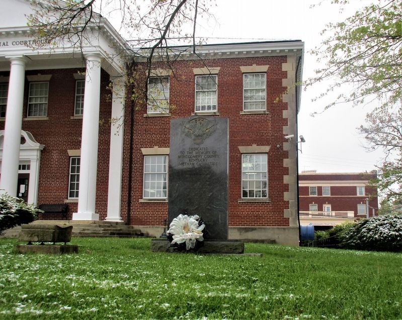
On Courthouse Square (County Route 1066) at North Maysville Street (U.S. 460), on the right when traveling west on Courthouse Square.
Dedicated to the Memory of
Montgomery County, Kentucky
Vietnam Casualties
Leonard Wayne Campbell
PFC U.S. Army
Apr 11, 1941 Oct 13, 1967
George Edward Corey
LCPL U.S. Marine Corps
Aug 25, 1945 Jul 24, 1966
Edward Taul . . . — — Map (db m172469) WM
On Courthouse Square (County Route 1066) at North Maysville Street (U.S. 460), on the right when traveling west on Courthouse Square.
In Memoriam
Montgomery boys who died for America in the Great War
Roger Baker ·
Charles Blevins ·
Dee Carter ·
Howard Cassidy ·
Andy Cooper ·
James Gibbs ·
James Gibson ·
Walter Hopkins ·
Moton Judy ·
Arthur Karrick · . . . — — Map (db m172475) WM
Near Gourd Creek Cemetery Road 0.1 miles north of Farm to Market Road 1375.
Born in Virginia, Elijah Collard later settled on the frontier in Kentucky and in Missouri, where he fought in the War of 1812. Collard migrated to Texas in 1833. He was elected to the Consultation at San Felipe in 1835 and served on the General . . . — — Map (db m180242) HM
Nashville was founded as part of
the movement by British colonists
from North Carolina and Virginia
into the Cumberland Valley in the
mid to late 18th century. Richard
Henderson, a magistrate, judge,
and land speculator from
Granville County, . . . — — Map (db m207200) HM
On Guthrie Highway (U.S. 79) 0.1 miles south of Oakland Road, on the right when traveling south.
One and a half miles north was the home of Reuben Ross, who came to Montgomery County in 1807. By 1808 he was leading numerous Baptist churches in middle Tennessee and southern Kentucky. Contributing significantly to the settlement of the area, . . . — — Map (db m146184) HM
On West Vandalia Street (Illinois Route 157) at St. Louis Street, on the right when traveling west on West Vandalia Street.
Early Political Career
Born in 1775 in Montgomery County, Maryland, Ninian Edwards moved to Kentucky in 1794 and was elected to the Kentucky legislature in 1795. He was appointed to serve as Chief Justice in the Kentucky Court of Appeals . . . — — Map (db m263411) HM
Near Old Mulkey Park Road 0.2 miles west of Old Mulkey Road.
Hannah Boone was the youngest child born to Squire Boone and Sarah Morgan Boone.
The Boones were members of the Friends Society (Quakers) and Squire served as first a trustee and then an overseer of the Oley Meeting. The Boones moved to the Yadkin . . . — — Map (db m184060) HM
On Kentucky Route 191 0.8 miles east of Route 203, on the left when traveling east.
Traditionally, healing properties
of mineral water of a spring here
discovered by owner when treating
her pet dog for mange. Its use by
humans spread and by 1895 three
hotels and many boarding houses
were hosts to people from all . . . — — Map (db m146572) HM
On North Bell Street at Waverly Street, on the left when traveling north on North Bell Street.
Following the Civil War, area farmers found the climate and soil conditions of Montgomery County were ideal for the production of tobacco. The varieties grown here were of the highest quality, winning international awards in Chicago and Paris. At . . . — — Map (db m127478) HM
On Ranch to Market Road 187 1 mile north of Waresville Cemetery Road, on the left when traveling north.
Capt. William Ware was born in 1800 to Joseph and Elizabeth Ware in Kentucky (Georgia in some sources). In 1828, he and his wife, Ann Murphy, and their three children moved to Montgomery County, Texas. From there, Ware raised a military company in . . . — — Map (db m155556) HM
Near Resaca Lafayette Road Northwest (Georgia Route 136).
Schofield's Army of the Ohio, consisting of two divisions, one commanded by the Brig. Gen. Jacob D. Cox, the other by Brig. Gen. Henry M. Judah carried out one of two Union attacks on 14 May. Major Gen. John M. Palmer provided support for the right . . . — — Map (db m170999) HM
On Farris Drive at Drane Street, on the left when traveling west on Farris Drive.
The Montgomery County Negro Agricultural Fair Montgomery County African Americans held an annual agricultural fair in Clarksville from 1948 to 1962. The fair showcased achievement in agriculture, home economics, wood crafts, art, and foodways. . . . — — Map (db m205338) HM
Near Darnestown Road (Maryland Route 28) just east of Seneca Road ( Route 112), on the left when traveling east.
The thriving crossroads community of Darnestown during the 1880s looked much different than it does today. Photographs from that time, however, help us understand what someone traveling through Darnestown might have experienced.
Darnestown grew . . . — — Map (db m69722) HM
On Brooke Road 0.1 miles west of Chandlee Mill Road, on the right when traveling west.
A former slave, Minister, Author, Abolitionist and Entrepreneur
Born a slave, a son of Charles County, Maryland; a historical figure trudging through the toils and injustices in life as a slave in Montgomery County, Maryland and Kentucky . . . — — Map (db m205932) HM
On Research Boulevard/County Line Road (Ohio Route 835) 0.1 miles north of Shakertown Road, on the left when traveling north.
Side A:
A Shaker village called Watervliet, Ohio, was located here from 1806-1900. The Shakers, originally called the United Society of Believers in Christ's Second Appearing, were followers of Mother Ann Lee who came from Manchester, England . . . — — Map (db m26345) HM
On Old Beaver Road (Route 1274) at Big Woods Road, on the right when traveling west on Old Beaver Road.
In April 1793, thirty-five Indians
attacked Morgan’s Station, a fort
in Montgomery County, and captured
nineteen residents. Pursued by
a group of settlers, the Indians
killed some captives at Murder
Branch in Menifee County. After
a skirmish . . . — — Map (db m146651) HM
Old Auxvasse Presbyterian is one of the oldest congregations west of the Mississippi. But this hill on which the congregation first met in 1828 in a log church earlier hosted travelers along the Trial, some of whom likely were buried here before . . . — — Map (db m216974) HM
Near South 2nd Street (Tennessee Route 76) south of Franklin Street, on the left when traveling south.
Yet again history was repeated when fire damaged the County's Courthouse on March 12, 1900. The upper floor of the 1879 building was destroyed and fell through to the first floor. The fire was believed to have started in the southeast section of the . . . — — Map (db m169084) HM
(West face)
[Confederate States of America Emblem]
Dedicated to the glory and
honor of the Montgomery
County soldiers of the
Confederate States of America
for their unparalleled courage
and gallantry in defense of their
homeland and . . . — — Map (db m22220) WM
Near Zion Road south of Sundown Road, on the right when traveling north.
In 2004, this trail corridor was named in honor of the mother of the modern environmental movement, Rachel Carson. When complete, the Rachel Carson Greenway Trail will be 25 miles long, connecting the Anacostia Trail System in Prince George's . . . — — Map (db m114413) HM
On Old Georgetown Road (Maryland Route 187) 0.1 miles south of Tilden Lane, on the right when traveling south.
Born into slavery in 1789, Josiah Henson was purchased as a child by Adam Robb and transferred here to the Riley plantation in 1795. The Rileys enslaved him for over 30 years until he escaped with his wife and children from Kentucky to . . . — — Map (db m189537) HM
On Brooke Road 0.1 miles west of Chandlee Mill Road, on the right when traveling west.
Countee Cullen: Poet, Anthropologist, Novelist, Translator, Children's Author, and Playwright
Countee Cullen died in 1946; he was only 42 years. In the centuries of the 20s and 30s he along with his friends Arna Bontemps, . . . — — Map (db m188351) HM
Near Norwood Road (Maryland Route 182) 0.1 miles north of Ednor Road, on the right when traveling north.
In 2004, this trail corridor was named in honor of the mother of the modern environmental movement, Rachel Carson. When complete, the Rachel Carson Greenway Trail will be 25 miles long, connecting the Anacostia Trail System in Prince George's . . . — — Map (db m162744) HM
Near Colesville Road (U.S. 29) south of Hillwood Drive, on the left when traveling north.
In 2004, this trail corridor was named in honor of the mother of the modern environmental movement, Rachel Carson. When complete, the Rachel Carson Greenway Trail will be 25 miles long, connecting the Anacostia Trail System in Prince George's . . . — — Map (db m114368) HM