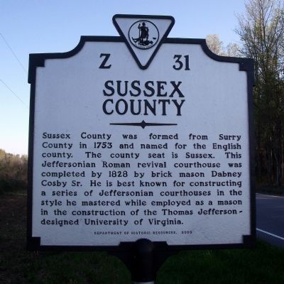
On Plank Road (Virginia Route 35) 0.5 miles north of Big Woods Road, on the right when traveling south. Reported missing.
Southampton County. Southampton County was formed in 1749 from Isle of Wight County, a part of Nansemond County was added later. The county was either named for the English borough of Southampton or for Henry Wriothesley, third earl of . . . — — Map (db m316091) HM
On General Mahone Highway (U.S. 460) at Skeet lane, on the right when traveling west on General Mahone Highway.
Sussex County. Area 515 Square Miles. Formed in 1753 from Surry, and named for an English county. Cornwallis passed through this county in 1781.
Southampton County. Area 604 Square Miles. Formed in 1748 . . . — — Map (db m18110) HM
On York Road (State Road 600) at Germanna Highway (State Highway 3), on the right when traveling east on York Road.
Before the creation of independent African American churches throughout Virginia, the enslaved often attended church with their owners. Laws regulating African American gatherings and worship became increasingly strict in the 1830s following "Nat . . . — — Map (db m152626) HM
On Main Street (Virginia Route 58) at Court Street, on the left when traveling east on Main Street.
One of the oldest buildings in Southampton County, Mahone’s Tavern was a social, transportation, and political hub of Jerusalem (now Courtland) because of its proximity to the county courthouse. Beginning in 1796, the structure served as a . . . — — Map (db m18118) HM
Near Fort Lane, on the right when traveling north.
Colonel John Cooke was born in Portsmouth, Virginia and resided at 809 Dinwiddie Street. He was the son of Mordecai Cook and a graduate of Princeton College, New Jersey.
In 1832 he was a Lieutenant in the troop of cavalry which left this . . . — — Map (db m297586) HM
On Florence Street east of Main Street ( Route 35).
Courtland School, which served African American
students during the segregation era, was erected
here in 1928-29 at a cost of $4,000. The local
African American community raised $1,000, while
the county contributed $2,500. The Julius
Rosenwald . . . — — Map (db m107407) HM
Near Lee Highway (U.S. 211) at Sperryville Pike (U.S. 522).
Caroline Terry, known locally as “Sis-tah Cah-line” (1833-1941) was born a slave, perhaps in Southampton County, but spent most of her life in Rappahannock County. She later took the surname Terry. By 1846, Francis Millan of Culpeper . . . — — Map (db m26518) HM
Near Aquia Path 0.5 miles west of Old Bridge Road ( Route 742), on the right when traveling east.
In 1600, there were approximately 40 tribes in Virginia. Today, the Commonwealth officially recognizes only eleven tribes.
When the Jamestown Settlers arrived in Virginia in 1607, they encountered several Virginia Tribes. The Chesapeake . . . — — Map (db m120348) HM
Near Kentucky Route 235 0.1 miles south of Road 761, on the left when traveling south. Reported permanently removed.
Note: this marker is weathered and partly illegible. Some words are inferred and others are indecipherable. George Henry Thomas was born in Southampton County, Virginia, July 31, 1815. At the age sixteen he was forced to flee his home along . . . — — Map (db m62970) HM
On Bride Street east of Alley Street, on the right when traveling east.
Near where you are standing today once stood the so-called "Hanging Tree," Southampton County's "usual place of execution" for criminals, both White and Black. Nat Turner was hanged here on November 11, 1831. The executioner was Edward Butts, . . . — — Map (db m290880) HM
On Gordon Street at Thomas Avenue, on the right when traveling west on Gordon Street.
Thomas, born in Southampton County, Virginia, graduated from West Point in 1840 and joined the artillery. He saw action in the Seminole War and the Mexican War and had frontier duty. He commanded the 14th Corp at Chickamauga. He became known as the . . . — — Map (db m82748) HM
On Court Street just north of East King Street, on the left when traveling north.
Jailhouse History The original Edenton jail was built in 1722 when the town incorporated. The present jail is the county's fifth. Ebenezer Paine constructed it in 1825, probably using 1773 plans by John Hawks, architect of . . . — — Map (db m224498) HM
On South Main Street (U.S. 258) at Elm Street, on the right when traveling south on South Main Street.
This property has been
placed on the
National Register
of Historic Places
by the United States
Department of the Interior
circa 1937 — — Map (db m166008) HM
On Colonial Trail E (Route 10), on the right when traveling north.
Surry County. Surry County, named for the county of Surrey in England, was formed from James City County about 1652. The Quiyoughcohannocks, whose villages were primarily situated in present-day Surry County, were among the first Virginia . . . — — Map (db m2680) HM
Near Canal Walk at 5th Street Footbridge, on the left when traveling west.
Throughout the period of slavery in Virginia, enslaved people sought freedom through acts of resistance, self-liberation, and rebellion. At the start of the Civil War, enslaved people sought to aid United States troops at Fort Monroe. On January . . . — — Map (db m256292) HM
On Linden Street at Heritage Lane, on the right when traveling north on Linden Street.
The 1831 Southampton Insurrection is considered the most consequential slave revolt in North American history. It was, however, preceded by many others. Slaveholders lived in fear of such uprisings as enslaved people of African descent often . . . — — Map (db m276512) HM
Near Watson Road at North Battlefield Boulevard (Virginia Route 168), on the left when traveling south.
(side 1)
This monument honors
Patriots who assembled
at this site in the Cause of
American Freedom in 1775
American Patriots
at the Battle
Second Virginia Regiment
Commanded by
Colonel William Woodford,
of . . . — — Map (db m211239) HM
On Main Street at Southampton Parkway (U.S. 58), on the right when traveling south on Main Street.
The Stealthlike Nottoway of 1650
Edward Bland’s 1650 account of his journey along the lower reaches of the Nottoway and Meherrin river valleys contains the earliest known written record of direct contact between the Nottoway and . . . — — Map (db m226144) HM
On Rochelle Street (County Road T-611) at Main Street (Business U.S. 58), on the left when traveling north on Rochelle Street.
The local militia mustered here on August 22, 1831, after the news of Nat Turner's uprising spread throughout Southampton County.
Governor John Floyd
Governor John Floyd, a War of 1812 veteran, held a militia commission as brigadier . . . — — Map (db m276518) HM
On N. Pine Street at W. Tennessee St on N. Pine Street.
Dred Scott, whose name is associated with the landmark U.S. Supreme Court Dred Scott Decision of 1857, was born in Virginia between 1795-1809. In 1818 he was in Madison County, Alabama. He came to Florence with the Peter Blow family in 1820. About . . . — — Map (db m35183) HM
On South Main Street (U.S. 301) 0.1 miles north of Church Street, on the right when traveling north.
Hicksford Lodge No. 37, the first in Greensville County, was chartered in 1793. It became dormant by 1829, but several former members, with new recruits from Southampton County, formed Widow's Son Lodge No. 150, Ancient Free and Accepted Masons of . . . — — Map (db m18948) HM
On Library Road (County Road 683) at Old Mill Road (County Road 683), on the right when traveling west on Library Road.
While there were no large-scale military actions, several dozen skirmishes and many troop movements occurred here. As a gateway to the northern Shenandoah Valley, the county was a major thoroughfare for both Union and Confederate forces on a . . . — — Map (db m171306) HM
On Maherrin Road (Virginia Route 35) south of Cross Keys Road, on the right when traveling south. Reported permanently removed.
On the night of 21-22 August 1831, Nat Turner, a slave preacher, began an insurrection some seven miles west with a band that grew to about 70. They moved northeast toward the Southampton County seat, Jerusalem (now Courtland), killing about 60 . . . — — Map (db m305420) HM
On Main Street (Business U.S. 58) north of Rochelle Street (County Road T-611), on the left when traveling west.
Southampton County was established in 1749. Before the Europeans' arrival, the area south of the Blackwater River was inhabited by Native Americans primarily the Nottoway Indians. According to the 1830 census, Southampton County mostly contained . . . — — Map (db m276523) HM
On Main Street (Business U.S. 58) south of Court Street, on the left when traveling north.
You are at the site of the 1795 Federal-style Southampton County Courthouse. The trials of Nat Turner and many of his followers were held here after the defeat of their insurrection in 1831. The 1795 courthouse was replaced in 1834. The new . . . — — Map (db m276524) HM
Near Main Street (U.S. 258) at South Street, on the right when traveling west.
Paul and James Camp started P.D. Camp and Company, a lumber business, in 1877. The brothers bought R.J. Neely's sawmill in 1886 and established Camp Manufacturing Company in 1887. The original Franklin mill was steam powered and lay on a . . . — — Map (db m51001) HM
On Meherrin Road (Virginia Route 35) south of Cross Keys Road, on the right when traveling south.
On 21 Aug. 1831, enslaved preacher Nat Turner began an insurrection five miles west of here with a force that grew to about 60 men. They killed nearly 60 white people before the revolt was suppressed within two days. In retaliation, white . . . — — Map (db m290875) HM
On South Main Street at South Street, on the left when traveling south on South Main Street.
Before the Civil War erupted, Franklin became a regional transportation and commercial center for the Blackwater-Chowan River basin because the seaboard and Roanoke Railroad connected with steamship lines here. When the war began, the town . . . — — Map (db m18133) HM
Near Clay Street (Business U.S. 58) at Meadow Lane, on the left when traveling west.
Dedicated to those who gave their lives
in defense of our state and our nation
Originally a part of the James L. Camp homeplace,
the park was given to the town of Franklin in 1946
by the children of Mr. and Mrs. James L. Camp.
Rena . . . — — Map (db m125377) WM
On Heritage Lane north of Linden Street, on the right when traveling north.
You are here in Courtland, the county seat of Southampton County, Virginia, at the Rebecca Vaughan House's new site. This building was moved from its original location, five miles away from the end of a long lane off Barrow Road. the last . . . — — Map (db m276515) HM
On Main Street (Business U.S. 58) west of Rochelle Street, on the right when traveling west.
This home is one of Courtland's most significant properties on the National Register of Historic Places. The Rochelle-Prince House, built in 1814, is an excellent example of a Southeastern Virginia residence with Federal influences. The house was . . . — — Map (db m276520) HM
On Heritage Lane north of Linden Street, on the right when traveling north.
Nat Turner, an enslaved, self-taught preacher, believed that signs from Heaven guided him to initiate the slave revolt in which more White people were killed than in any other in American history. Born in Southampton County in October 1800, . . . — — Map (db m276516) HM
Near Mahan Street east of North Main Street ( Route 32).
1861 ~ 1865
More than 1,500 men and boys from Suffolk and Nansemond County left their homes and families in defense of constitutional liberty and states rights to face overwhelming odds. Many paid the ultimate price; all endured hardships and . . . — — Map (db m104106) HM WM
On South Main Street (U.S. 301) 0.1 miles north of Battery Avenue, on the right when traveling north.
"The railroad bridge was a prime target during the Civil War. The Confederates built three forts on the south side of the bridge and rifle pits and obstructions on the north side. On December 7-12, 1864 the Yankees made their “Hicksford Raid”, . . . — — Map (db m226936) HM
On Bride Street east of Alley Street, on the right when traveling east.
Two newspapers reported that Deputy Sheriff Edward Butts executed Turner at either high noon or one o'clock p.m. on November 11, 1831. Most sources agree that a large crowd gathered on the day of the execution. Yet only a few were permitted to . . . — — Map (db m290878) HM
On Clarendon Boulevard just east of Washington Boulevard, on the right when traveling west.
Arlington During the Conflict
Fifteen years after the U.S. ended its official military involvement in Korea, Arlington continued its association with the nation's military and intelligence operations. In place of the U.S. Army Signal . . . — — Map (db m236008) HM
Thin black lines indicate changes in relevance. Between each pair of lines entries are ordered geographically but all have the same relevance.
* Inflectional forms of words are their plurals, singulars, and possessives as well as gramatical tenses and similar variations.