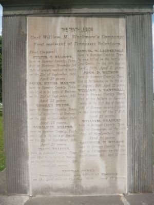
This Monument Was erected by the liberality of the Citizens of the County of Sumner to the memory of her Patriotic Sons: who sacrificed their lives in the defense of the Flag of their country in the war with Mexico. In 1846. 1847 & 1848. . . . — — Map (db m85162) WM
On Ben Albert Road at Tyree Springs Road (Tennessee Route 258), on the right when traveling south on Ben Albert Road.
A mineral springs resort was established here by R.C. Tyree sometime between 1814 and 1822. By 1834 it was the most celebrated watering place in the state. Presidents Andrew Jackson and James K. Polk were guests here. Burned during the Civil War, . . . — — Map (db m151838) HM
To the memory and in honor of our comrades of the Second Tennessee Infantry Regiment, C. S. A., who fell near this spot early on the morning of the battle of Shiloh, April 6, 1862. Go, stranger, and tell Tennessee that here we died for her. . . . — — Map (db m6924) HM
The Mexican War
Instigated by the U.S. annexation of Texas and the dispute over its southern boundary, the Mexican War of 1846-1848 resulted in the cession of over 500,000 square miles of the territory then owned by Mexico west of Texas and . . . — — Map (db m85159) HM
On West Main Street (Tennessee Route 25) at South Foster Street, on the right when traveling west on West Main Street.
By an act of the Tennessee General Assembly, Gallatin became the county seat of Sumner County on February 26, 1802, when commissioners sold the first town lots. Newly laid out, the town embraced 42 ½ acres. The site had been purchased from . . . — — Map (db m82971) HM
On Long Hollow Pike east of Upper Station Camp Creek Road, on the right when traveling east.
This is the home of four brothers who served in the Confederate army, as did many of Sumner County’s young men. Their father, William F. Clark, a Protestant minister, died in 1847 at the age of forty-one, leaving his wife, Emma Douglass Clark, to . . . — — Map (db m82973) WM
Near South Water Avenue (Old State Highway 109) at James Street, on the right when traveling south.
This monument marks Rose Mont and pays tribute to Major George Blackmore, father of Catherine Blackmore Guild, wife of Josephus Conn Guild, owner and builder of Rose Mont. Blackmore served in the Revolutionary War from 1777-1781. He came to . . . — — Map (db m68406) HM WM
Near Rachels Lane 0.3 miles east of Hermitage Road.
Andrew Jackson's strong sense of family extended beyond those he embraced during his lifetime.
Reaching into the future to touch generations yet to come, he deeded a small portion of the garden in trust to serve as a family cemetery. Stones . . . — — Map (db m85372) HM
On South Battery at Meeting Street, on the right when traveling west on South Battery.
In Memory of
The Supreme Devotion of Those Heroic Men
Of the Confederate Army and Navy
First in Marine Warfare
To Employ Torpedo Board
1863 - 1865
Moved by
The Lofty Faith That With Them Died
Crew After Crew
Volunteered
For . . . — — Map (db m47493) HM
Bate's grave is easy to locate as his monument has a raised relief of his profile. He was born at Castalian Springs in Sumner County. In 2004 the Bate home is still occupied as a private residence and noted by a historical marker on Highway 25. . . . — — Map (db m166480) HM
Near Northwest Broad Street (U.S. 41) at Memorial Boulevard ( Route 96), on the right when traveling south.
Rutherford County was established on October 25, 1803 from portions of Davidson, Williamson and Wilson counties. The county originally extended to Alabama on its southern boundary. The county was named for Revolutionary War
General Griffith . . . — — Map (db m146773) HM WM
On West Main Street at Hatton Road, on the right when traveling west on West Main Street.
On this site was the home of Robert H. Hatton that was unfortunately destroyed by fire after the war. He was born in October in 1826, but early in his life his family moved to Lebanon. He graduated from Cumberland University and then studied law at . . . — — Map (db m268193) HM
On Frank Clement Place west of Center Avenue ( Route 48), on the right when traveling west. Reported missing.
The railroad in front of you was part of a vital transportation network for the Federal army during the Civil War. W.H. Crutcher had purchased 533 acres and constructed a sixteen-by-sixteen foot log structure here in December 1860. After occupying . . . — — Map (db m221758) HM
Near Cemetery Street at Whatley Street, on the right when traveling north.
Carmack was born in Sumner County, Tennessee. Just a few years after his birth, his father died, leaving his mother to care for the small family. She found employment at the fledgling Webb School in Culleoka and brought her young family to Maury . . . — — Map (db m196614) HM
Cragfont was the home of Confederate Maj. George W. Winchester (1822-1878), his mother, Susan Winchester, his wife, Malvina H. Gaines, and their children. Their surviving letters and diaries describe life during Union occupation.
George . . . — — Map (db m68465) HM WM
On Frank Clement Place west of Center Avenue ( Route 48), on the left when traveling west.
The railroad in front of you follows the route of a vital U.S. Army rail line constructed during the Civil War. After occupying Middle Tennessee in the spring of 1862, Gen. Ulysses S. Grant's officers needed a reliable transportation link between . . . — — Map (db m221789) HM
Near Hartsville Pike (State Road 25) west of Rock Springs Rd.
There were very few Catholic priests on the frontier, and none visited Sumner County until about 1830. In their absence, area Catholics met at Rogana to read the prayers for Mass on Sunday and to keep their faith alive.
A Catholic in the . . . — — Map (db m263489) HM
Near 18th Avenue South 0.1 miles north of Edgehill Ave, on the right when traveling south.
In 1801, the western annual conference of the Methodist Episcopal Church was formed from districts in Ohio, Kentucky, Tennessee and Mississippi. This building, known as Strother's Chapel, was erected about 1800 near Cottontown, Sumner County. In . . . — — Map (db m308493) HM
On North Public Square at North Maple Street, on the left when traveling west on North Public Square.
For whom this county was named in 1803.
In the early years of the Revolutionary War he commanded all Military Forces west of the Alleghenies
(Text on back)
1776: Appointed Brigadier General - led 2400 men into the Tennessee . . . — — Map (db m221035) HM WM
On Visitors Center Lane at Donelson Parkway (Scenic U.S. 79), on the right when traveling south on Visitors Center Lane.
For over fifty years during the 19th Century, Stewart County was the center of the iron industry of Tennessee. For instance, in 1854, the county produced as much, tonnage-wise, as the next two largest producing counties in middle Tennessee and . . . — — Map (db m278525) HM
On Cages Bend Road at Douglas Bend Road, on the left when traveling south on Cages Bend Road.
Established in the home of William Dillard during the late 1700s, Rehoboth is the oldest continuing congregation in the Tennessee Conference of the Methodist Church. Rehoboth has provided Sumner County with a community-meeting place, voting site, . . . — — Map (db m220961) HM
On West Main Street (Tennessee Route 25) at South Locust Avenue, on the right when traveling east on West Main Street.
This was the home of William Trousdale (1790-1872), governor of Tennessee (1849-1851) and U.S. minister to Brazil (1853-1857). During the Union army’s occupation of Gallatin from 1862 to 1870, its commanders regarded former governor Trousdale as the . . . — — Map (db m68416) HM
On Highland Circle Drive, on the left when traveling south.
Founder of the Highland Adventist Community
Braden Mulford came to Tennessee in 1004 as a charter student of the Nashville Agricultural and Normal Institute (N.A.N.I)-later more commonly known as Madison College-near Nashville, Tennessee. EA . . . — — Map (db m220965) HM
Near Hartsville Pike 0.1 miles west of Old Highway 25, on the right when traveling west.
Hugh Rogan was born in 1747 in Glentourn, County Donegal, Ireland. In adulthood, Rogan served under the patriot of Gratton and when his chief's Cause failed, he fled to America in 1775 fearing arrest by the British. After a short time spent in . . . — — Map (db m180159) HM
On Main Street, on the right when traveling north.
•1881-1885 - Strawberry crops were first known to be grown here successfully.
•1908-1912 - Portland Strawberry Growers Association was organized, involving several local growers, and 107 railroad cars of strawberries were shipped out in 1912. . . . — — Map (db m220991) HM
On Dayton Mountain Highway (State Highway 30) at Walker Road, on the right when traveling west on Dayton Mountain Highway.
(obverse)
Rhea County
Established 1807; named in honor of
John Rhea
Revolutionary veteran, who fought at King's Mountain. Delegate to the North Carolina Convention which ratified the U.S. Constitution; member of the Tennessee . . . — — Map (db m63645) HM
On Madison Station Boulevard at Madison Street, on the right when traveling south on Madison Station Boulevard.
Amqui Station
Amqui Station was constructed in 1910 as a Lousiville and Nashville (L&N) railroad switching and passenger depot in Madison, Tennessee. The original station was located at the junction of the L&N and the Nashville, . . . — — Map (db m310609) HM
Frontiersman
William Hall's family came to Tennessee in 1785 and
settled near Bledsoe's Lick in Summer County. Two years
later, hostilities between settlers and Indians escalated into
war. Hall lost seven family members, including his . . . — — Map (db m207977) HM
On East Main Street (Tennessee Route 151), on the left when traveling east.
Named by early pioneers traversing thru the region, this designated Indian trail led these settlers into this area during Western migration. This mainly Cherokee trail, (although used some by the Shawnee), originated at Rockwood in Roane County, . . . — — Map (db m180021) HM
John Turner Tinsley was born circa 1802 in Sumner County, Tennessee to Moses and Elizabeth (Turner) Tinsley. He later became a physician and married Nancy Willis of Kentucky, with whom he had five children. The family came to Gonzales in 1834 and . . . — — Map (db m187444) HM
On West 70th Street 0.4 miles west of Shiloh Avenue, on the right when traveling west.
Susan C. Haile was born December 20, 1817, in Cape Girardeau, Missouri. She was the youngest child of Joseph and Prudence (Bledsoe) Seawell, natives of Sumner County, Tennessee. Upon the death of Joseph in 1819, Prudence Seawell returned to Sumner . . . — — Map (db m123807) HM
Frontier Nashville
European exploration of the Middle
Tennessee region began as early as the 16th
century with the expedition of Spaniard
Hernando de Soto. By the early 18th
century French traders were exchanging
furs with the area's . . . — — Map (db m207197) HM
Near Bledsoe Park Road 0.2 miles east of Zieglers Fort Road, on the right when traveling east.
Bledsoe Creek State Park borders historic early settlements and houses including Bledsoe's Lick, Cragfont, Wynnewood, and the Avery Trace in what had been an Indian hunting ground. During the Civil War, this prosperous river and railroad hub . . . — — Map (db m180166) HM
Near East Baddour Parkway, on the right when traveling north.
The story of Connected Sustainability.
Like all good stories, the Connected Sustainability project at the Fairgrounds has had its share of heroes and heroines. The story stretches over years of visions of possibility, nurturing of allegiances, . . . — — Map (db m268247) HM
Nathaniel Parker settled here during a volatile time. He successfully survived those dangerous years, eventually replacing this cabin with a brick house.
A Good Friend is Lost
Nathaniel Parker was close to fifty-five years old when he . . . — — Map (db m184864) HM
On Isaac Franklin Drive north of Plantation Way, on the left when traveling north.
Born in Sumner County, Franklin and his business partner John Armfield became wealthy by trading in slaves and cotton. In 1832, he built the mansion at Fairvue Plantation and in 1839 married Adelicia Hayes. They had four children; none survived to . . . — — Map (db m198974) HM
On Ronnie Mc Dowell Parkway (State Highway 109) at Main Street, on the right when traveling north on Ronnie Mc Dowell Parkway.
On October 31, 1859, Richland Station was opened 318 feet east of here by Thomas Buntin on land later deeded by his heirs to the Louisville and Nashville Railroad. Five months later, a post office was established, and Buntin, already the station's . . . — — Map (db m151856) HM
On Twin Oaks Drive at Teil Drive, on the left when traveling south on Twin Oaks Drive.
Anthony Sharpe, a Revolutionary War patriot, served in McCroy's Company, Ninth N.C. Regiment, was granted 3,840 acres of land in the new Tennessee county of Davidson. The grant was dated April 9, 1788 under Warrant No. 52 and was surveyed by William . . . — — Map (db m226877) HM
On 1st Avenue North at Union Street North, on the right when traveling north on 1st Avenue North.
Lynching in America
Thousands of African Americans were the victims of lynchings and racial violence in the United States between 1877 and 1950. After the Civil War, violent resistance to equal rights for African Americans and an ideology of . . . — — Map (db m147760) HM
On Nashville Road (U.S. 31W) at Rodgers Road (Route 259), on the right when traveling north on Nashville Road. Reported missing.
Tennessee
Sumner County
Established 1796 named in honor of Major Gen. Jethro Sumner. Officer in French and Indian War. Served in defense of Charleston, 1776; in the Battles of Brandywine and Germantown; and in . . . — — Map (db m102330) HM
Near Hartsville Pike (State Road 25) west of Rock Springs Rd.
Hugh Rogan built his family home to resemble those in his birthplace. Completed about 1800, the house originally stood on the Rogan farm three miles northeast of here.
The Rogan Family Home
Hugh Rogan was in his early fifties when be . . . — — Map (db m263492) HM
Near Hartsville Pike (Tennessee Route 25), on the right when traveling west.
Nathaniel Parker was a seasoned outdoorsman when he came to the Cumberland Valley to hunt and explore. After several forays to this area, he returned to Sumner County with his family.
Veteran of the French and Indian War
Nathaniel . . . — — Map (db m184863) HM
On Hartsville Pike (Tennessee Route 25) 0.2 miles west of Cragfont Estates Road, on the right when traveling west.
Built c. 1844 by John Fonville
for James B. Jameson
has been placed on the
National Register
of Historic Places
by the United States
Department of the Interior — — Map (db m178551) HM
On South Water Avenue (Old State Highway 109) at James Street, on the right when traveling south on South Water Avenue.
Rosemont, a Greek Revival—style mansion completed in the 1840s, was the home of Judge Josephus Conn Guild, a state senator and representative who also served as a Lt. Colonel in the 2nd Tennessee Mounted Volunteers during the Seminole War. He . . . — — Map (db m68405) HM
On Strand Street just south of King Street, on the right when traveling north.
On January 1, 1808, the earliest date allowed by Article I, Section 9 of the United States Constitution, the Act Prohibiting Importation of Slaves went into effect and stated, "It shall not be lawful to import or bring into the United . . . — — Map (db m188750) HM
Near Hartsville Pike (Tennessee Route 25) 0.1 miles west of Rock Springs Road.
Col. Anthony Bledsoe
Born in Culpepper Co. VA, 1733
Killed by Indians about 200 yards west from this spot, July 20, 1788.
and his wife, Mary Ramsey Bledsoe
Born in Augusta Co. VA, 1734
Died in Sumner Co. Tenn, 1808
Col. Issac . . . — — Map (db m180309) HM
On Hartsville Pike west of Old Highway 25, on the right when traveling west.
Between Isaac Bledsoe's fort and Anthony
Bledsoe's Greenfield, the frontier slave,
identified in early accounts only as “Abram"
and belonging to Col. Anthony Bledsoe,
thwarted an April 27, 1793 Indian attack
on Greenfield. Two months later, . . . — — Map (db m170822) HM
Thin black lines indicate changes in relevance. Between each pair of lines entries are ordered geographically but all have the same relevance.
* Inflectional forms of words are their plurals, singulars, and possessives as well as gramatical tenses and similar variations.