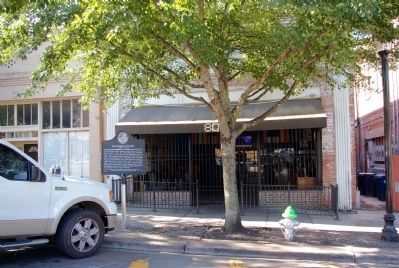
On E. Washington Street 0 miles east of North Lumpkin Street, on the left when traveling west.
Georgia’s pioneer aviator, Benjamin Thomas Epps, was born in Oconee County in 1888. He opened Athens’ first automobile repair garage at this location on East Washington Street in 1907. That same year, nineteen-year-old Epps designed and built his . . . — — Map (db m11755) HM
On Ben Epps Drive, on the right when traveling north.
Ben T. Epps - Georgia's First in Flight -- designed, built and in 1907 flew the first airplane in the State of Georgia. He was born in Oconee County, educated in Clarke County, and attended Georgia Tech. A self-taught aviator, aircraft designer, and . . . — — Map (db m11754) HM
On North Thomas Street at East Washington Street, on the right when traveling north on North Thomas Street.
In summer 1996, Athens, Georgia, shone as the largest Olympic venue site outside Atlanta, as the state hosted the Centennial Olympic Games July 19 - August 4. Some 650,000 visitors bought tickets to events at three University of Georgia venues: . . . — — Map (db m11870) HM
On North Main Street (Georgia Route 15) at Third Street North, on the right when traveling north on North Main Street.
Eagle Tavern, or Hotel, was the center of social and political life in Watkinsville for more than a hundred years. It was saved from destruction in 1934 by Lanier Richardson Billups of Decatur, Georgia, who deeded it to the State in 1956.
The . . . — — Map (db m14081) HM
Near Capitol Avenue Southwest near Capitol Square Southwest, on the right when traveling north.
To prevent British soldiers from capturing the city of Augusta, the Battle of Kettle Creek was fought on Valentine's Day, 1779. 600 British loyalists occupied Wilkes County, a few miles from Washington, Georgia, at an area known to the locals as . . . — — Map (db m215342) HM
Near East Broad Street east of First Street, on the right when traveling east.
In 1783 the Oconee River basin was the western boundary of the new United States of America. The first U.S. frontiersmen included surveyors, mapmakers, native guides, and naturalists.
To entice farmers to the new territory, the U.S. . . . — — Map (db m206381) HM
On Court Street near Main Street, on the right when traveling south.
Clarke County established 1812. Named for General John Clarke of Georgia. County Seat moved here 1832 from Clarksville to Grove Hill, then known as Macon. — — Map (db m47655) HM
On East Broad Street, on the left when traveling east.
1954-2004
Presented to Athens Clarke-County by the Commanding Officer of the U.S. Navy Supply Corps School in commemoration of the Golden Anniversary of a Classic Partnership.
For half a century, the U.S. Navy has teamed with Athens-Clarke . . . — — Map (db m207823) HM
On East Broad Street east of Foundry Street, on the right when traveling east.
In the mid-1800s, it was hand to get around in Clarke County. Roads were rutted and unpaved, and large cargo boats struggled to navigate the Oconee River. By 1888, Athens was a small but growing city. That summer and fall workers laid tracks for a . . . — — Map (db m296518) HM
Near South Poplar Street north of Oak Street, on the left when traveling north.
Run -off water from the upper piedmont forms the Oconee (a Native American word meaning "river").
Below the Appalachian Mountains of North Georgia, the Oconee River headwaters begin in the rolling hill country of Hall and Gwinnett Counties . . . — — Map (db m207633) HM
Near State Street at Hoyt Street, on the right when traveling north.
Statues
Parterre gardens frequently incorporated statues in their design. Each corner of this garden has a statue dedicated to the arts, representing music, sculpture, painting, and architecture.
Garden Centerpiece
Parterre gardens . . . — — Map (db m199968) HM
On North Thomas Street, on the right when traveling north.
Athena, designed by artist Jean Westmacott,
Oglethorpe County, Georgia, was carved of
marble from the mountains of Carrara, Italy
by the Carlo Nicoli Studio. The pedestal is
fashioned of Georgia granite from Elbert
County. The sculpture, which . . . — — Map (db m207209) HM
Near Hoyt Street at North Jackson Street, on the left when traveling east.
The Ware Family
In 1829, at the age of 22, Dr. Edward R. Ware and his wife, Elizabeth, moved to the rapidly-growing frontier town of Athens, Georgia. Ware soon built a successful medical practice.
Ware was active in commerce and business. . . . — — Map (db m199959) HM
On Epps Bridge Parkway at Timothy Road, on the right when traveling south on Epps Bridge Parkway.
The Chestnut Grove Schoolhouse was established in 1887 to meet the educational aspirations of Black children. It was built and equipped by local Black farmers. The land was donated by a Black farmer named Floyd Kenny, who could not read or write. . . . — — Map (db m56883) HM
Near South Poplar Street north of Oak Street, on the left when traveling north.
In the early 1920s, with increasingly common use of the auto, the streetcar business declined and was discontinued in 1930.
After World War II, the city and county were on a course of rapid expansion that would see the population of the city . . . — — Map (db m207631) HM
On Mars Hill Road 0.2 miles west of Hog Mountain Road ( Route 53), on the right.
Jeannette Rankin (1880-1973) was the first woman to serve in Congress: being elected from Montana in 1916 before women had the right to vote in other states. She was active in women's suffrage and was a peace advocate who opposed all war. She was . . . — — Map (db m14079) HM
On U.S. 84 at milepost 40 at Crescent Road, on the right when traveling east on U.S. 84.
Side 1
Near this spot are the graves of American Revolution soldier Elijah Pugh and his son Issac, a War of 1812 veteran. Elijah, born in Guilford Co., N.C. in 1760, was 18 when he joined a patriot band led by Col. Elijah Clarke at the . . . — — Map (db m154482) HM
Near Oconee Street (Business U.S. 78) 0.4 miles west of South Poplar Street, on the right when traveling west.
The construction of the Seaboard Air Line Railway main line into Athens made this area a destination for national touring companies and famous personalities.
Rail connected Athens to all parts of the country, allowing culture and . . . — — Map (db m207620) HM
Near East Broad Street east of Wilkerson Street, on the right when traveling east.
Mills were located at shoals in the river where water dropped quickly, providing power for manufacturing. Clarke County had 19 mills, and many were located on the Athens riverfront.
A dam constructed in the 1830s on the rocky shoals downstream. . . . — — Map (db m207644) HM
On West Cobb Street at South Jackson Street (Alabama Route 295), on the right when traveling west on West Cobb Street.
This cabin was built in the 1830s by Josiah Mathews.
It is an example of a two-room log cabin. This type of cabin was commonly built by early 1800s settlers who came from the Carolinas and Georgia on the Federal Road to Clarke County. The cabin . . . — — Map (db m234676) HM
On West Cobb Street at North Jackson Street (Alabama Route 295) on West Cobb Street.
Far beneath parts of Clarke, Washington, and Mobile
counties sit vast deposits of salt. In some places, natural
springs bring salty water known as brine from this
enormous underground salt dome up to the surface.
For as long as this geological . . . — — Map (db m234677) HM
On Cemetery Street east of East Campus Road, on the right when traveling south.
That the memory of the men of Clarke County, who gave their lives in the World War in defense of their country and to perpetuate its ideals, shall live as an inspiration to courage and patriotism.
1914 - 1918
• Chester P. Adair
• Harry . . . — — Map (db m276664) WM
Near Capitol Avenue Southwest south of M.L.K. Junior Drive Southeast, on the left when traveling north.
Expelled Because of Color” is dedicated to the memory of the 33 Black state legislators who were elected, yet expelled from the Georgia House because of their color in 1868.
The cinder block forms at the base of the sculpture symbolize the . . . — — Map (db m130191) HM
Thin black lines indicate changes in relevance. Between each pair of lines entries are ordered geographically but all have the same relevance.
* Inflectional forms of words are their plurals, singulars, and possessives as well as gramatical tenses and similar variations.