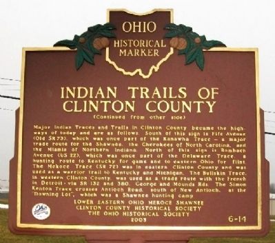
Clinton County was a major center of activity for the Shawnee, Miami, and Delaware Indians. Early traces and trails developed as Indians traveled from village to village; gathered flint, salt and gold; traded furs, mica, and feldspar; and hunted . . . — — Map (db m27827) HM
On East Birdsall Street at North South Street (U.S. 68), on the right when traveling east on East Birdsall Street.
The Wilmington Public Library of Clinton County, one of 111 Carnegie libraries in Ohio, opened its doors to readers on June 30, 1904. A $12,500 gift from steel magnate and philanthropist Andrew Carnegie financed construction of the original . . . — — Map (db m225374) HM
The 19th century saw a great migration of Quakers from the Carolinas and from eastern Ohio to southwestern Ohio. Attracted by rich soil and abundance of fresh water and springs, Quakers became the dominant religious group in the region. Clinton . . . — — Map (db m27837) HM
On August 9, 1968, a plane carrying 31 military passengers and crew members left the Clinton County Air Force Base for completion of an annual two-week active duty training held at Otis Air Force Base, Massachusetts. The transport was assigned to . . . — — Map (db m227443) HM
On South Street (U.S. 68) just south of East Main Street (U.S. 22), on the left when traveling south.
The Clinton County Courthouse was dedicated October 22, 1919. The Cincinnati firm of Weber, Werner and Adkins designed the edifice and it is a local masterpiece that fuses the Beaux-Arts and Neo-Classical architectural styles. A grand marble . . . — — Map (db m227483) HM
On Prairie Road (County Route 21) at Starbuck Road (County Route 11), on the left when traveling east on Prairie Road. Reported missing.
Near this site in October 1786 General Benjamin Logan with an army of 700 Kentucky volunteers camped on their way to destroy seven Indian towns in the Mad River Valley. During the night a renegade deserted the camp to warn the Indians. The army . . . — — Map (db m121033) HM WM
On Main Street at Corwin Street (Ohio Route 63), on the right when traveling west on Main Street.
One of the most effective political orators of his era, Tom Corwin (nicknamed "the Wagon Boy" for his War of 1812 service) resided here from 1839 until his death. A Whig stump speaker known for his wit and eloquence, he was elected governor of Ohio . . . — — Map (db m24061) HM
On Park Drive near Rombach Avenue (U.S. 22), on the left when traveling south.
On April 18, 1964, reservists from the 302nd Troop Carrier Wing at the Clinton County Air Force Base (CCAFB) and 2nd Special Forces Group (Green Berets) of Fort Hayes, Columbus were to undergo an Operational Readiness Inspection. In a flight of . . . — — Map (db m121127) HM WM
On Davids Drive east of Ohio Route 134, on the left when traveling east.
Before and during World War II, the aviation industry was vulnerable
to adverse weather conditions, particularly thunderstorms. In 1945,
Congress mandated the nation’s first large-scale, scientific study of
thunderstorms. The Thunderstorm Project . . . — — Map (db m134868) HM
Near East Main Street (U.S. 22) at South Walnut Street, on the right when traveling east.
Revolutionary War
Clinton County did not exist when the Revolutionary War was fought, but it was the brave veterans of that war who settled this area of Ohio. Short on cash, our young country paid her soldiers with land grants in the newly . . . — — Map (db m214753) WM
On Findlay Street at Baymiller Street, on the right when traveling east on Findlay Street.
Side A Camp Joy was born at the site of Seven Hills Neighborhood House and original location of St. Barnabas Episcopal Mission Church. Displacement and loss caused by Ohio River flood of 1937 inspired St. Barnabas’ rector and his wife, . . . — — Map (db m134938) HM
On West Main Street (Ohio Route 63/123) east of South Corwin Street, on the left when traveling east.
The house at 210 W. Main Street was built in 1818 by Phineas Ross, an attorney and the cashier of the first bank in Warren County. Here, on Nov. 13, 1822, his sister Sarah married future Ohio Governor and U.S. Senator Thomas Corwin. Ross died in . . . — — Map (db m246524) HM
On West Cirlce Drive, on the right when traveling west.
Side 1
Philip Orin Parmelee, noted early aviator, lived a tragically brief but venturesome life. Born in 1887 in Matherton, Michigan, Parmelee grew up in nearby St. Johns, Clinton County, where he developed a keen interest in . . . — — Map (db m233545) HM
Near Lincoln Highway (U.S. 30) just west of Monroe Avenue, on the right when traveling west.
In 1912, there were approximately one million motor vehicles registered in the United States but few good roads. Most of the roads outside of urban areas were dirt that turned to mud when wet. Long-distance travel by car was still very much a . . . — — Map (db m162418) HM
“One day while plowing I heard a voice,”
whether inside me or outside of me I knew not,
but I was awake.
It said, ‘Go thou and see the president.’
I answered, ‘Yea, Lord, thy servant heareth.’
and unhitching my plow, I went at once to . . . — — Map (db m28002) HM
A.B. Miami U.
LL. B. Cincinnati Law School
Founder- Beta Theta Pi
Member of the Society of Friends
Prosecuting Attorney of
Clinton County
Member of Ohio Senate
Director of B&O RR
Kansas Pioneer
Judge
Circuit Court-Linn Co. . . . — — Map (db m133404) HM
On Ohio Route 73 just west of Collett Road (County Route 232), on the right when traveling east.
Jonah’s Run Baptist Church.
The comingling of faiths in an area settled predominantly by
Quakers helps explain the origins of Jonah’s Run Baptist Church.
Ministered to by a Baptist preacher, the children and neighbors of
Daniel Collett . . . — — Map (db m141498) HM
On Ohio Route 72 0.3 miles north of County Road 156, on the right when traveling north.
Dedicated to the memory of these early Ohio Pioneer Residents of Clinton County
1841 William Geffs •
1882 William Geffs •
1864 Harrison Geffs •
1844 Harrison Geffs •
1908 Thomas Geffs •
1912 Mary Geffs •
1840 John Geffs • . . . — — Map (db m213425) HM
Thin black lines indicate changes in relevance. Between each pair of lines entries are ordered geographically but all have the same relevance.
* Inflectional forms of words are their plurals, singulars, and possessives as well as gramatical tenses and similar variations.