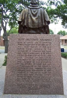
On West Third Avenue near North 13th Street, on the left when traveling east.
Lover of liberty. Foe of despotism. Born in San Antonio, Texas, February 27, 1795. Died January 13, 1871 and buried there. Member of the Legislature of Coahuila and Texas, 1821; land commissioner of De Witt's colony 1831 and of Bexar District, . . . — — Map (db m62998) HM
A native of Huntsville, Texas, Samuel R. Frost grew up in Navarro County and in 1863 enlisted in the Confederate Army. After the Civil War he studied law and was admitted to the bar in 1870. In the years that followed, Frost served as Navarro . . . — — Map (db m309070) HM
On County Highway SW 2340 near Austin Avenue (State Highway 14).
In town founded after the Houston & Texas Central Railroad bypassed older villages. An early store was moved from Pisgah Ridge (5 Mi. W) by J.T. and Prudence Anderson Patrick, who settled in Richland in 1870. They had three sons, Walter, Jim, and . . . — — Map (db m164960) HM
Several communities in Navarro County organized military units that saw action in the Civil War. Company E of the 15th Texas Infantry was formed on April 16, 1862, when two squads were combined into one unit under the leadership of Captain Joshua . . . — — Map (db m60758) HM
On West Park Avenue, on the right when traveling west.
Born in Kentucky. Came to Texas 1849. Civic and political leader. Represented Navarro County in Legislature, 1859-60. Joined in call for State Secession Convention, 1861. Joined 3rd Texas Cavalry. Later a colonel in 10th Texas Infantry. Wounded in . . . — — Map (db m60954) HM
On Business Interstate 45 2 miles south of Interstate 45, on the right when traveling north.
Formed from Robertson County
Created April 25, 1846 Organized July 13, 1846
Named in honor of
Jose Antonio Navarro
1795-1871
Soldier, patriot and statesman,
Signer of the Texas
Declaration of Independence,
Member of the Texas . . . — — Map (db m152966) HM
During the Civil War, the Navarro Rifles were an infantry company comprised of approximately 87 men from Navarro and surrounding counties. The group formed in Corsicana in July 1861 to join the army of the Confederate States of America. . . . — — Map (db m62268) HM
On S Waco Street (State Highway 22/171) near W Gould Street, on the right when traveling south.
In 1853, the Texas Legislature carved Hill County out of Navarro County. Named for physician and Republic of Texas Secretary of War Dr. George Washington Hill, the new county had only recently attracted Anglo settlement, following the establishment . . . — — Map (db m60160) HM
Near Farm to Market Road 744 0.2 miles east of County Highway 2120.
A native of Georgia, David Wilson Campbell migrated to Texas in 1835. He served in the Texas Army the following year during the Texas War for Independence. A pioneer farmer in Navarro County, he gave ten acres of land to the Harmony Methodist Church . . . — — Map (db m217630) HM
On Starr Street (State Highway 184) 0.1 miles north of Rice Street, on the right when traveling north.
In 1946, W.O. Stringer, County Judge and owner of Stringer Funeral Home in Jasper, opened a second facility in Hemphill, on the corner of Worth Street and FM 2971 (Beckcom Road). Stringer hired Tennessee native John Byron Starr, Sr. (1909-1978) to . . . — — Map (db m290429) HM
South Carolina native Edward H. Tarrant enlisted in the Kentucky Militia in 1814 and served under Gen. Andrew Jackson in the Battle of New Orleans. Moving to Tennessee after 1816, he was elected Colonel of the Henry County Militia and served as . . . — — Map (db m188852) HM
On Farm to Market Road 1603 at Rice Road on Route 1603.
Francis Marion Martin, also known as “Swamp Fox of Navarro,” was a 19th century Texas politician, holding the office of Lt. Governor from 1883-1885. In the dynamic post-Civil War period, he championed farmers and laborers, garnering significant . . . — — Map (db m217186) HM
On Dr. Martin Luther King Jr. Boulevard (Business U.S. 31) at S 5th Street, on the right when traveling west on Dr. Martin Luther King Jr. Boulevard.
Born into slavery in Smith Station, Alabama, to parents Anderson and Clara Jackson, George Washington (G.W.) Jackson (1856–1940) was a pioneer Navarro County educator, author, civic and religious leader for 52 years. His parents valued education . . . — — Map (db m310045) HM
On Grand Avenue north of 1st Ave, on the right when traveling north.
The now-iconic statue welcoming visitors to the annual State Fair of Texas began in 1949 as a marketing campaign for the Chamber of Commerce in Kerens, Navarro County. To promote holiday shopping, Kerens citizens constructed a 42-foot Santa Claus . . . — — Map (db m313758) HM
On North 12th Street north of West 5th Avenue, on the left when traveling north.
Soon after Navarro County was created by the Texas Legislature in 1846, a committee was appointed to choose a site for the county seat. The committee selected a 100-acre tract of land that came to be the city of Corsicana.
The town was named . . . — — Map (db m60061) HM
On Robinson Way, on the right when traveling south.
Born in Georgia, where he fought in Indian Wars, was a merchant, and member of State Legislature. In 1839, he moved with family to Texas, settling in this area. He was a member of 6th Congress of the Republic of Texas, 1841-1842; a delegate to the . . . — — Map (db m128922) HM
On West 2nd Street (State Highway 22) near North 24th Street, on the right when traveling east.
Born in 1790 in North Carolina, James Clinton Neill came to Texas in 1831 with Stephen F. Austin's third colony. He settled in Milam County, and represented his neighbors at the Convention of 1833. On September 28, 1835, Neill entered the Texas Army . . . — — Map (db m63149) HM
On South Main Street near West 6th Avenue, on the right when traveling south.
First public use of natural gas began in Texas in 1902, from transmission lines on this street, serving local homes and businesses. These early lines were forerunners of mains that now transport Texas gas to three-fourths of the United States and . . . — — Map (db m61400) HM
On West 2nd Avenue, on the right when traveling east.
Thomas Ingles Smith was born in 1800 in Virginia and was a soldier in the War of 1812 in a company commanded by his father, General Bird B. Smith.
Smith arrived in Texas late in 1836, and soon enlisted in the Republic of Texas army under Gen . . . — — Map (db m60599) HM
On Southwest CR-0030 at Farm to Market Road 1394, on the left when traveling north on Southwest CR-0030.
An early Navarro County conflict, rooted in land disputes and complex family ties, still resonates in the region. During the Republic of Texas period, this area was subject to clashes with native peoples, as with the Battle Creek Fight or . . . — — Map (db m272068) HM
On Farm to Market Road 47 1.8 miles east of County Road 3707, on the right when traveling east.
Van Zandt County was among the Texas counties that voted for secession in the spring of 1861 as the Civil War loomed. At the outbreak of the conflict, Texas troops began training for service to the Confederate States of America (C.S.A.). Military . . . — — Map (db m244647) HM
On North 15th Street, on the right when traveling north.
A Texas War for Independence soldier. Born in Virginia. Lived in Tennessee, where he joined 15 other recruits late in 1835 to come to Texas and fight against dictator Santa Anna. Served Jan. 14 to Sept. 18, 1836. Was awarded two land bounties for . . . — — Map (db m62677) HM
On West 3rd Avenue near North 13th Street, on the left when traveling east.
Navarro County was created in 1846 by an act of the first Texas Legislature. It was named for early statesman Jose Antonio Navarro (1795-1871), a signer of the Texas Declaration of Independence. The first county seat was established at the home of . . . — — Map (db m62139) HM
On County Highway 3170 0.2 miles Farm to Market Road 709, on the right when traveling south.
Granted a bounty of Navarro County land for his participation in the Battle of San Jacinto, April 21,1836, cattleman Britton Dawson (1817-1905) settled here in 1847. He occupied a three-room cabin before erecting this two- and-one-half story Greek . . . — — Map (db m214236) HM
On North 1st Street at South Main Street, on the right on North 1st Street.
This community grew out of Spring Hill (4mi. NE), the oldest settlement in Navarro County. A Republic of Texas Indian agent, Dr. George Washington Hill, started Spring Hill in 1838 as a trading post to improve relationships with the Indians. . . . — — Map (db m214233) HM
On North College Street at East Main Street (MLK Jr. Blvd), on the right when traveling north on North College Street.
Emory W. Rogers was born in Lawrence County, Alabama on July 2, 1813. Nancy Clinton was born on October 28, 1810. The Couple Married in 1833.
Mr. Rogers obtained a "Headright" certificate from the Republic of Texas in 1839, for 640 acres of . . . — — Map (db m212735) HM
On Sycamore Avenue west of North 24th Street, on the right when traveling west.
In 1923 Beauford H. Jester (1893-1949) and his wife, Mabel (Buchanan), built this colonial revival home on land that had been his family's dairy farm. A Corsicana attorney, Jester later served as chairman of the University of Texas Board of Regents . . . — — Map (db m247011) HM
On East 5th Avenue at North 9th Street, on the right when traveling west on East 5th Avenue.
Born in Tennessee on December 31, 1851, James Emerson Whiteselle moved to Texas in 1870 to work in the lumber company of his uncle P. W. Ezell. In 1875 he began working in the local Carruthers Lumber Company which he later owned. Under his . . . — — Map (db m62898) HM
On U.S. 287 west of County Road SE 2240, on the left when traveling west.
Born in Navarro County in white-columned house across pasture south of this site. Began to write poetry when he was 15 years old. Author of more than 500 published poems which appeared in many major magazines; won numerous poetry prizes.
Moved . . . — — Map (db m247009) HM
On State Highway 123 3.1 miles north of Interstate 10, on the right when traveling north.
Born in San Antonio, Jose Antonio Navarro (1795-1871) held several offices in the Mexican government before becoming an active participant in the movement for Texas independence. Navarro possessed numerous landholdings in this part of the state. . . . — — Map (db m111184) HM
On County Road 1040 0.1 miles north of Farm to Market Road 3041, on the left when traveling north.
The James Hamilton, Jr. family left Tennessee for Texas ca. 1841. Upon James' death in Arkansas, his wife Elizabeth and their children continuned the journey, arriving in Navarro County ca. 1846. Elizabeth Hamilton died on August 7, 1857, and is . . . — — Map (db m309678) HM
On Garitty Street (Farm to Market Road 667) near South Front Street, on the right when traveling south.
Prior to 1887 the community of Cross Roads existed two miles south of this location. The town of Frost was created when a post office was established in March of that year to serve settlements west of Corsicana along the St. Louis, Arkansas, and . . . — — Map (db m60211) HM
On College Avenue at N Barron St, on the right when traveling west on College Avenue.
Established about 1860 by the founder of Covington, Col. James Gathings, and his brother Philip.
Over 200 students enrolled. A military department prepared young men for duty in Civil War. Many of the 25 colleges in Confederate Texas closed, . . . — — Map (db m264559) HM
First important oil field in Texas
opened here October 15, 1895.
First successful refinery in Texas
Completed Christmas Day , 1898
— • —
Plaque presented to
The Citizens of Corsicana
by the
Texas Mid-Continent Oil and . . . — — Map (db m60492) HM
On North 13th Street near West 2nd Avenue, on the left when traveling north.
A center of patriotism especially committed to the Southern cause. After the Nov. 1860 presidential election, citizens lowered the Stars and Stripes and ran up the Texas flag on the Courthouse. Early in 1861 influential men beat drums on the Square . . . — — Map (db m61783) HM
On East 6th Avenue near South 8th Street, on the left when traveling west.
The first newspaper in Navarro County, called the "Prairie Blade," began publication in 1855 and was owned by Dan Donaldson. By 1859 the paper was owned by R. A. Van Horn who changed its name to the "Navarro Express." Paper was in short supply . . . — — Map (db m61921) HM
On West 4th Avenue near North 22nd Street, on the right when traveling west.
A native of Kentucky, Ewing Eric Dunn (1835-1917) came to Texas in 1850. He served as Navarro County deputy
sheriff, 1854-1858, and joined the Confederate army during the Civil War. In 1866 he built the first portion of this
frame house. . . . — — Map (db m60840) HM
On North 45th Street (Farm to Market Road 2555) 0.1 miles north of Skylane Ave, on the left when traveling north.
Born in Shelby County, Kentucky, to Stephen and Birthia (Ford) Drane, Meritt Drane exemplified leadership in early Navarro County. His father was a wealthy farmer and stock raiser. Meritt's education consisted of homeschooling and learning how to . . . — — Map (db m309661) HM
Expert with acetylene torch, Nicol is remembered as first welder operating in the Navarro County oil fields, which opened 1894. He began work about 1912, at a time when he had to mix own welding chemicals. In addition he pioneered welding of cast . . . — — Map (db m60912) HM
On West 1st Avenue near North 12th Street, on the left when traveling west.
The Texas Legislature specified that the seat of Navarro County should be called Corsicana; but the location was not secured until 1848 when this site was donated by David R. Mitchel, James C. Neill, and Thomas Smith. Other structures served briefly . . . — — Map (db m304401) HM
On Farm to Market Road 744 0.3 miles west of South Kerr Street (State Highway 55), on the right when traveling south.
The Rev. James E. Ferguson (1824-76), father of Texas Governor James Ferguson, was appointed in 1847 to Richland (later Dresden). The first Methodist circuit in Navarro County. Ethan Melton (1793-1873), the founder of Dresden - which was "Richland" . . . — — Map (db m212866) HM
On Houston Street at 3rd Street, on the left when traveling south on Houston Street.
The Barry Baptist Church congregation, originally organized as the Elam Baptist Church congregation, was established in September 1891 with seven charter members. The Rev. C. R. Roberts became the congregation's first pastor in June of 1892. Early . . . — — Map (db m61156) HM
On Whiteselle Street at North Front Street, on the right when traveling south on Whiteselle Street.
This congregation traces its history to the 1860s, when a Methodist congregation was formed in the community of Cross Roads (about 2 Mi. S). After the railroad was built through Navarro County in 1887, the church and community moved to the new town . . . — — Map (db m212063) HM
On Austin Street at Marshall Street, on the right when traveling south on Austin Street.
Members of the Fortson family came to Texas from Mississippi and settled in Navarro County in the 1840s. Civil War veteran James T. Fortson wed Ida Clayton, daughter of another pioneer area family, in 1867, and they moved to the Rice area in 1872. . . . — — Map (db m164899) HM
A native of Scotland, Alexander Beaton came to the United States in 1843. He migrated to Texas in 1848 after serving in the U.S. Army during the Mexican War. In 1850 he settled in Corsicana and began the practice of law. He was chairman of the . . . — — Map (db m60493) HM
On U.S. 77 0.3 miles south of South Central Boulevard (State Highway 342), on the right when traveling south.
Created December 20, 1849
from Navarro County
Organized August 5, 1850
Named in honor of
Richard Ellis, 1781-1846
a Virginian by birth and education
Jurist and statesman of Alabama
1813-1825
Moved to Texas in 1825
President . . . — — Map (db m152372) HM
Near Farm to Market Road 744 0.2 miles east of County Highway 2120.
Land for this cemetery was given to the Harmony Methodist Church in 1855 by Navarro County pioneer David Wilson Campbell. Ten acres were donated to the church trustees, with part to be set aside as a graveyard and known as Campbell Cemetery. David . . . — — Map (db m217629) HM
On North 15th Street, on the left when traveling north.
David Reed Mitchell, born in 1797 in North Carolina, arrived in Robertson County, Texas, in 1845. He was a surveyor
by trade, and had surveyed the upper Trinity and Brazos River areas in 1844. He became surveyor of the Robertson
County Land . . . — — Map (db m62464) HM
Near 400 Block of South 12th Street, on the right when traveling north.
This pipe denotes the location of the successful
water well that led to the oil discovery
(Upside down text)
This pipe denotes the location of the first
commercial oil discovery in Texas — — Map (db m60868) HM
West of the Mississippi River, in
this well, drilled by H. G. Johnston,
E. H. Akin, and Charles Rittersbacher
under contract for a water well
for the city of Corsicans in
1894, the first oil in commercial
quantities in the . . . — — Map (db m60000) HM
Near North Dresden (County Highway 1070) 1 mile north of Calhoun Street.
The Rice community was settled during the late 1860s and was named for William Marsh Rice, who donated land for the town's railroad station and later founded Rice University. In 1868, the citizens of the community were granted land for a cemetery . . . — — Map (db m164900) HM
On South 45th Street (Farm to Market Road 2555) at Oak Valley Road on South 45th Street.
Oak Valley was one of thirty school districts created in Navarro County in 1867 by County Judge John L. Miller and a committee composed of E. G. Melton, John M. Bright, L. H. Dunham, J. C. Wells, J. M. Quinlan, and G. W. Foster. Classes were not . . . — — Map (db m309654) HM
On County Highway 3140 0.5 miles State Highway 31, on the left when traveling south.
North Carolina native Alexander Younger (1786-1866) and his wife Jane Merchant (Hancock) (1798-1881) came to Texas in 1847. They first settled in present Ellis County, where they were granted land in the Peters Colony. By 1850 they had moved to . . . — — Map (db m214219) HM
On North Waco Street (State Highway 81), on the left when traveling north.
Created February 7, 1855
Organized May 14, 1853
Named in honor of
Dr. George W. Hill
1814-1860
Member of the Texas Congress
and Legislature
Secretary of War of the
Republic of Texas, 1843-1845
Lexington, first village . . . — — Map (db m62522) HM
On West 4th Avenue near North 22nd Avenue, on the right when traveling west.
John Spencer Callicutt moved to Corsicana in 1886 and opened his law practice. As an active member of the community, Callicutt served on the founding board of the county hospital, as well as the boards of Central State Bank and other businesses. A . . . — — Map (db m63571) HM
On State Highway 22, on the right when traveling east.
The land on which the Pinkston Community would be established was owned by Doctor Alexander
Colvin Sloan, who was born in 1843 in Montgomery, Alabama. He served in the Civil War and around 1870 migrated to Navarro County. In 1887, he sold . . . — — Map (db m62239) HM
On North 12th Street at W 5th Ave, on the left when traveling north on North 12th Street.
Commandancy of the Alamo-
Bexar, Feby. 24th 1836-
To the people of Texas & all Americans in the world--
Fellow citizens & compatriots
I am besieged, by a thousand or more of the Mexicans under Santa Anna - I have sustained a continual . . . — — Map (db m309073) HM
On West Park Avenue near North 15th Street, on the left when traveling east.
1914 1918
In Memory Of The Men Of Navarro County Texas
Who Lost Their Lives In The World War Charles B. Johnson Lewis Wiggins
Isaiah D. Adams James O. Johnson
Perry A. Allison William V. Keel . . . — — Map (db m63941) WM
Thin black lines indicate changes in relevance. Between each pair of lines entries are ordered geographically but all have the same relevance.
* Inflectional forms of words are their plurals, singulars, and possessives as well as gramatical tenses and similar variations.