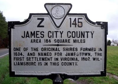
On Old Stage Road (Virginia Route 30) 0.1 miles south of Richardson Road ( Route 705), on the right when traveling east.
New Kent County. Area 191 Square Miles. Formed in 1654 from York, and named for an English county. The White House, where Washington's wife lived, was in this county, and here he married her.
James City County. Area . . . — — Map (db m29299) HM
On East Williamsburg Road (U.S. 60) 0.1 miles east of White Oak Road, on the right when traveling east. Reported missing.
Henrico County. Area 280 Square Miles. An original shire formed in 1634. Named for Henrico Town, founded in 1611, which was named for Henry, Prince of Wales. The battles of Seven Pines, Savage's Station, Glendale, and Malvern . . . — — Map (db m298735) HM
On Eltham Road (Virginia Route 33) 0.1 miles south of Virginia Avenue, on the right when traveling south.
Established in 1654 from York and named for County Kent, England. In it are Chestnut Grove, Birthplace of Martha (Dandridge) Custis; White House, home of Martha Custis; Poplar Grove, where Martha Custis met George Washington; St. Peter's church, . . . — — Map (db m17606) HM
Near New Kent Highway at Courthouse Circle. Reported permanently removed.
Lord Cornwallis's army was here, moving eastward, June 22, 1781; Lafayette, in pursuit, June 25; Washington, Rochambeau and Chastellux, on their way to Yorktown, September 14, 1781. A part of Joseph E. Johnston's army, retiring to Richmond, passed . . . — — Map (db m17738) HM
On East Williamsburg Road (U.S. 60) 0.1 miles east of White Oak Road, on the right when traveling east. Reported missing.
Established in 1654 from York and named for County Kent, England. In it are Chestnut Grove, Birthplace of Martha (Dandridge) Custis; White House, home of Martha Custis; Poplar Grove, where Martha Custis met George Washington; St. Peter's church, . . . — — Map (db m298734) HM
On Outpost Road 0.6 miles south of Rockahock Road, on the right when traveling south.
(left panel)
Sustaining Courage for Exploration
In December 1607 John Smith set out from Jamestown to continue his exploration of the Chickahominy River, which had begun with a series of trading voyages in November. He visited . . . — — Map (db m83910) HM
Near Lot Cary Road (Virginia Route 602) at Samaria Lane, on the left when traveling south.
John Smith explored the upper Chickahominy River in December 1607. He left his boat and seven of his crew at Apocant, the highest town on the river in the upper part of what is today the lake. Two crew members departed with Smith and two . . . — — Map (db m61883) HM
On Eltham Road (Virginia Route 33) 0.1 miles south of Virginia Avenue, on the right when traveling south.
Eltham, a mile north, was long the home of the Bassett family and one of the largest and finest colonial houses in Virginia. Burwell Bassett, the owner at the time of the Revolution, was a patriot leader. Washington was a frequent visitor at Eltham . . . — — Map (db m21601) HM
On Mastin Lane east of West Broad Street, on the left when traveling north.
Shineforth Child & Family Services (originally known as the Virginia Conference Orphanage of the Methodist Episcopal Church, South) was incorporated in 1900 and opened here in 1902. Organized as an agricultural community, the orphanage maintained . . . — — Map (db m309204) HM
Near Wilcox Neck Road (Virginia Route 623) 0.5 miles north of The Glebe Lane ( Route 615).
(left panel)
Sustaining a Credible Illusion
The Jamestown settlement was facing a severe food shortage in November of 1607. Captain John
Smith set out to trade for corn with the Indians living along this river. He traveled from . . . — — Map (db m46511) HM
On New Kent Highway (Virginia Route 249) 0.1 miles west of Courthouse Circle.
To the revered memory
of
The Confederate
Soldiers and Sailors
from New Kent County
1861 - 1865
"Lest we forget
Military units organized in New Kent.
Pamunkey Rifles
Co. E. 53, Virginia Regiment.
Barhamsville . . . — — Map (db m167833) WM
On North Courthouse Road (Virginia Route 155) at Poindexter Road (County Route 604), on the left when traveling north on North Courthouse Road.
George Poindexter (Poingdestre), a member of
prominent family on the Isle of Jersey in the
English Channel, arrived in Virginia by the 1650s
and settled at Middle Plantation, now Williamsburg.
He acquired land in at least three . . . — — Map (db m107387) HM
On Old Union Road (Virginia Route 603) 0.1 miles east of Roxbury Road ( Route 106), on the right when traveling east.
Roxbury was named for a nearby plantation in New Kent County and reached by Longbridge over the Chickahominy. This community was the site of a colonial era tavern and the only railroad station in Charles City County . Roxbury post office (1883-1953) . . . — — Map (db m29158) HM
On Adkins Road (Virginia Route 618) at Church Lane, on the right when traveling south on Adkins Road.
In May 1862, Union Gen. George B. McClellan led the Army of the Potomac up the Peninsula to the gates of Richmond. Confederate Gen. Robert E. Lee assumed command of the Army of Northern Virginia in June and began planning a counterattack. On June . . . — — Map (db m61881) HM
On Maidens Road (U.S. 522) at Maidens Loop, on the right when traveling south on Maidens Road.
This area was most likely first named for "Maiden's Adventure Farm," a nearby estate mentioned in the 1755 will of John Fleming. By 1824, construction of the James River and Kanawha Canal reached Maidens Adventure. In 1825 the Maidens Adventure Dam . . . — — Map (db m257024) HM
Near Courtland Farm Road (Virginia Route 820) 0.2 miles east of Hanover Courthouse Road (U.S. 301), on the right when traveling east.
(side 1)
The Colonial River Road
After centuries of use by native people and the colonists of New Kent County, the road along the Pamunkey River was extended past the tobacco ports of Newcastle and Page’s Warehouse (later . . . — — Map (db m53801) HM
On Main Street south of 5th Street, on the left when traveling south.
Col. John West II (1633-1689) inherited 6,000 acres of this land from his father, John West I. Land-grant ca. 1650. John West II was taken prisoner during Bacon's Rebellion. He later sat on court martial for those "Rebels". He was Colonel of Militia . . . — — Map (db m218258) HM
On Cumberland Road 0.2 miles north of New Kent Highway ( Route 249), on the right when traveling north.
Earliest History of Cumberland Plantation
Cumberland and the nearby Pamunkey River exhibit abundant evidence of Chief Powhatan's 'Great Nation' before and following the arrival of the Europeans at Jamestown in 1607. When the . . . — — Map (db m271817) HM
On New Kent Highway (Virginia Route 249) 0.1 miles east of Courthouse Circle, on the right when traveling east.
Samuel W. Crump, a native of New Kent County and a veteran of World War II, was among the first African Americans elected to public office in Virginia under the state's Constitution of 1902, which disenfranchised many black voters. Elected to the . . . — — Map (db m167831) HM
On Hanover Courthouse Road (U.S. 301) 0.2 miles north of Depot Road, on the right when traveling north. Reported permanently removed.
General Washington and General Rochambeau passed here on Sept. 13, 1781 on their way to victory at Yorktown. One mile south, they turned east on state route 605.
The marking of this route is a gift from the French Government. Committee of the . . . — — Map (db m226210) HM
Near Cumberland Road 0.8 miles north of New Kent Highway ( Route 249), on the right when traveling north.
In the Summer of 2020, the United States was divided on many social issues including racial justice. Large cities, Virginia's capital among them, struggled with how to remember our country's history of slavery. Cumberland Estate commissioned . . . — — Map (db m272312) HM WM
Near Emmaus Church Road (Virginia Route 106) at Interstate 64, on the left when traveling north.
October 12th of 1994 Stansley Racing Corp. was awarded the first pari-mutuel license for the state of Virginia. The facility you see is a concept of his son, Brett Lee Stansley, who had the rendering done in a colonial style.
Arnold is . . . — — Map (db m61899) HM
On Cople Highway (Virginia Route 202) at Sandy Point Road ( Route 604), on the right when traveling east on Cople Highway.
Two miles east. Built in 1655 of oak timbers sheathed with clapboards. Rebuilt of brick in 1706. In this vicinity Mary Ball lived under the tutelage of Colonel George Eskridge, of Sandy Point, from 1721 until her marriage to Augustine Washington in . . . — — Map (db m22400) HM
Near National Avenue north of Smith Boulevard, on the left when traveling north.
John Parke Custis was the adopted stepson of George Washington and had been raised at the nearby Washington estate of Mount Vernon. He and his wife, Eleanor Calvert, lived in New Kent County with their first two daughters. However, Custis wanted to . . . — — Map (db m298471) HM
John Parke Custis
Born at White House, New Kent County in 1755. Died at Eltham, New Kent County, November 1781, where his body remains.
This marker placed by the Sons of the Revolution in Virginia 1960
While acting as aide to . . . — — Map (db m17746) HM
Near Berkley Street at North Center Street, on the right when traveling west.
In the late 19th and early 20th centuries, opportunities for Black education were scarce in Ashland and Hanover County. Despite these challenges, Berkleytown became a hub for education and community progress, embodying the broader struggle for equal . . . — — Map (db m296362) HM
Thin black lines indicate changes in relevance. Between each pair of lines entries are ordered geographically but all have the same relevance.
* Inflectional forms of words are their plurals, singulars, and possessives as well as gramatical tenses and similar variations.