On Bendview Court just south of Main Street (New Brunswick Route 106), on the left when traveling south.
The Moncton 100 Monument honours Joseph Salter, shipbuilder, entrepreneur and first mayor of the Township of Moncton in 1855.
Local entrepreneurs, whose names are inscribed on this monument, undertook funding of the project as their gift to the . . . — — Map (db m106613) HM
English: From the bygone days of New Brunswick's "Golden Age of Sail", its once-prosperous commercial fishery, and its growing tourism and ecotourism industry, the Petitcodiac River continues to play an important role in the . . . — — Map (db m150992) HM
Near Assomption Boulevard, 0.2 kilometers east of Westmorland Street, on the right when traveling east.
English: Historically, the Petitcodiac River was home to a large number of fish species. Both the rainbow smelt and Atlantic tomcod numbered in the hundreds of thousands. There were healthy populations of gaspereau, American eel, . . . — — Map (db m150985) HM
On Bendview Court just south of Main Street (New Brunswick Route 106), on the left when traveling south.
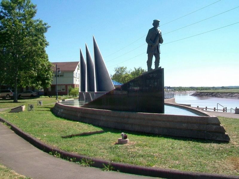
In memory of the 1.5 million martyrs
of the Armenian Genocide
and
all victims of genocide
A la mémoire de 1,5 millions de martyrs
du génocide arménien
et
de toutes les victimes de génocide — — Map (db m106601) HM WM
Near Main Street (New Brunswick Route 106) 0.1 kilometers west of Wheeler Boulevard, on the right when traveling east.
English: The Settlers of the Township of Monckton reached their destination after 44 days at sea, on June 3, 1766. Captain Jonathan Hall guided the sloop along Pennsylvania's Schuylkill River to the New England coast, then entered . . . — — Map (db m151002) HM
On Downing Street north of Assomption Boulevard, on the right when traveling north.
English: The Provincial Bank Building (opposite) is located at the corner of Main and Downing. Commissioned in 1909 by the Provincial Bank of Canada to be its Maritime Provinces headquarters, this building was occupied by the bank . . . — — Map (db m150996) HM
On Main Street (New Brunswick Route 106) just east of Ruelle Oak Lane, on the right when traveling east.
English: Built in 1926, the Capitol Theatre was designed by Moncton architect René-Arthur Fréchet and features frescoes by Emmanuel Briffa. With its deep, opera-style stage, the theatre has accommodated both motion pictures and live . . . — — Map (db m150964) HM
On Downing Street at Assomption Boulevard, on the right when traveling north on Downing Street.
English: Downing Street is the namesake of Johanna Downing, a Moncton resident from 1840 until 1876. She and her husband, Peter McSweeney, moved from Ireland to Hillsborough, New Brunswick, in 1832. Peter later became a farmer, real . . . — — Map (db m150995) HM
On Queen Street just west of Church Street, on the right when traveling west.
On this site a house of worship was erected in 1857 destroyed by fire 1913 present building dedicated to the glory of God May 16, 1915 160th Anniversary June 8, 1988 Heritage Moncton Inc. — — Map (db m151005) HM
On Main Street (New Brunswick Route 106) at Bendview Court, on the right when traveling east on Main Street.
This part of "Le Coude" (The Bend) was in earlier times called Terre-Rouge. Three families from the Grand-Prée region first settled here:
Jean Babineau & Isabelle Breau, circa 1733,
followed by Joseph Breau & Isabelle Thibodeau
and Charles . . . — — Map (db m106603) HM
On Downing Street north of Assomption Boulevard, on the right when traveling north.
English: Downing Street was an important hub for many industries relying on various modes of transportation for the arrival and shipment of cargo and merchandise. Français: La rue Downing était une plaque tournante . . . — — Map (db m150998) HM
Near Main Street (New Brunswick Route 106) 0.1 kilometers west of Wheeler Boulevard, on the right when traveling east.
English: 1 • This journey began in Europe where eight families, seven of German origin, and one of Welsh origin, set out to seek a new homeland. It ended here, on these muddy Banks of the Petitcodiac River, when the families of . . . — — Map (db m151001) HM
On Queen Street just west of Church Street, on the left when traveling west.
This plaque commemorates Methodism in Moncton 1781 Ministry of Methodist Preachers 1822 Circuit established 1828 Methodist Society formed 1847 First denominational church in Moncton, corner of Main and Wesley Streets 1877 . . . — — Map (db m151214) HM
On Downing Street just north of Assomption Boulevard, on the right when traveling north.
English: These maps and street directories of Moncton show businesses and homes once located on Downing Street. Français: Ces cartes et répertoires de Moncton montrent les entreprises et résidences autrefois situées . . . — — Map (db m150999) HM
Near Main Street (New Brunswick Route 106) 0.1 kilometers west of Wheeler Boulevard, on the right when traveling east.
English: In honour of the permanent settlers of the Monckton township, the Stief, Lutz, Treitz, Jones, Sommers, Copple, Ricker and Wortman families who came up the Petitcodiac River from Pennsylvania and landed on the bank of this . . . — — Map (db m151000) HM
On Botsford Street (New Brunswick Route 134) north of Queen Street, on the right when traveling north.
First wooden church erected in 1872 Cornerstone present church laid 1888 100th anniversary of first celebrated mass November 1, 1991 November 1, 1891 — November 1, 1991 Heritage Moncton Incorporated — — Map (db m150993) HM
On Downing Street north of Assomption Boulevard, on the right when traveling north.
English: The Peter McSweeney Company Limited (700 Main) offered a special sale called the Red and Green Tag Campaign twice a year, when the tides allowed customers to arrive by ship in the morning to go shopping and return home in . . . — — Map (db m150997) HM
Near Main Street (New Brunswick Route 106) 0.1 kilometers west of Wheeler Boulevard, on the right when traveling east.
English: When they first arrived, the settlers lived together in small, rough cabins. But soon, each family built its own home, as stipulated in the Articles of Agreement. Initially, all livestock was housed in a communal shed. The . . . — — Map (db m151003) HM
Near Assomption Boulevard, 0.2 kilometers east of Westmorland Street, on the right when traveling east.
English: Because of access to the Atlantic Ocean and an abundance of timber, communities along the Petitcodiac, like others in New Brunswick, flourished during the "Golden Age of Sail". It began as early as 1827, when Moncton was . . . — — Map (db m150981) HM
Near Main Street (New Brunswick Route 106) just west of Wheeler Boulevard, on the right when traveling east.
English: Powered by the high tides of the Bay of Fundy, the tidal bore has fascinated visitors and residents for generations. It was considered one of the top tidal phenomena in the world until the construction of a causeway in the . . . — — Map (db m150960) HM
On Westmorland Street just south of Main Street (New Brunswick Route 106), on the right when traveling south.
Built in 1900 by John T. Hawke, Publisher and Editor of The Transcript Revitalized in 1990 by the Law Firm of Ellsworth Johnson & Partners Registered as a Historic Place on September 9, 1996 This commemorative plaque was erected by Ellsworth . . . — — Map (db m150994) HM