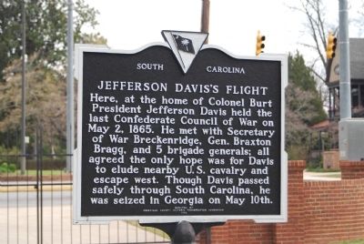
On North Main Street (State Highway 71) at Greenville Street (State Highway 20) on North Main Street.
Burt-Stark House When Jefferson Davis, President of the Confederacy, left Richmond after its fall in April 1865, he traveled south, trying to reach and rally the remnants of his army. On May 2, he spent the night at the home of Col. Armistead . . . — — Map (db m10564) HM
On Main Street at Greenville Street, in the median on Main Street.
This tablet was placed here to commemorate the last meeting of the Confederate States Cabinet which was held in the Burt House near by directly in front of this stone.
The following cabinet members were present:
Jefferson Davis, President . . . — — Map (db m73949) HM
On SC Highway 56, on the right when traveling south. Reported missing.
Jefferson Davis, President of the Confederacy on his flight from Richmond, Va. with his Cabinet and other high ranking officers spent the night of April 30, 1865 at the house 1½ miles west, then the home of Lafayette Young. Arriving there . . . — — Map (db m55837) HM
A. Grand Lake Cutoff
Mile 511.0 AHP
An oxbow lake two miles west of the river, Grand Lake, was removed from the channel by this natural cutoff in the 1700’s. The small river town of Princeton grew up on the west bank, with a busy landing. . . . — — Map (db m115524) HM
Near Lock and Dam Road 0.7 miles north of 2nd Street West, on the right when traveling north.
For more than 10,000 years, people have lived near the Mississippi River. The first cultures relied on hunting, fishing, and gathering for survival. As early as 1,000 years ago, however, Indian peoples were farming portions of the river valley near . . . — — Map (db m49801) HM
On Congress Avenue just south of East 18th Street.
The initiator of Anglo-American settlement in Texas. Moses Austin was a native of Durham, Connecticut. After his marriage to Mary Brown in 1785, Austin became a leading figure in the development of the American lead industry. His business took him . . . — — Map (db m158896) HM
On U.S. 231 0.2 miles north of State Route 36, on the right when traveling north.
Abundant water and fertile land in this area south of the Tennessee River attracted pioneer settlement in the early 1800s. The community established here by three Virginia-born brothers, Hopkins, John, and Theophilus Lacy, took on their name and . . . — — Map (db m27611) HM
On East Columbus Street just east of North Main Street, on the left when traveling east.
In 1835, the county’s first settler’s home was built here by Adam Ritchey. The Moorehead family owned the land for the next 100 years. The first school was also here. — — Map (db m185713) HM
On County Road 430 0.6 miles south of County Road 248, on the left when traveling south.
Northern Boundary of:
British W. Florida 1764-83
Spanish W. Florida 1783-95
Mississippi Territory: 1798-1804
Washington County 1800-12
Clarke County 1812-15
Southern Boundary of:
British Illinois 1764-83
United States . . . — — Map (db m73532) HM
On 4th Avenue (U.S. 11) 0.6 miles north of Longshore Drive, on the right when traveling north.
Northern Boundary of:
British W. Florida 1764-83
Spanish W. Florida 1783-95
Mississippi Territory: 1798-1804
Washington County 1800-12
Clarke County 1812-15
Southern Boundary of:
British Illinois 1764-83
United States . . . — — Map (db m89725) HM
On Farm to Market Road 1155 0.6 miles south of Farm to Market Road 2193, on the left when traveling north.
When Texas seceded from the Union on March 2, 1861, and became part of the Confederate States of America, Confederate training grounds and Union prisoner of war camps were established in the area. Camp Felder was established as a cavalry base . . . — — Map (db m217120) HM
On East Washington Street, on the right when traveling east.
The oldest remaining colonial settlement in East Alabama from Florida to the Tennessee line and older than the county of Henry and the state of Alabama. An active trading post was located here in the Alabama Territory on “The Hill” early in 1819. . . . — — Map (db m83757) HM
On Red Fox Road 3.2 miles west of U.S. 43, on the right when traveling west.
Aiokpanchi, "Welcome,” to the Official Tribal Reservation
of the MOWA Band of Choctaw Indians. Chata hapia hoke!
"We are Choctaw.” We are glad you are able to visit us and
hope your visit to our Tribal Reservation is both rejuvenating
and . . . — — Map (db m149288) HM
On West High Street (Missouri Route 8) at South Missouri Street, on the right when traveling east on West High Street.
Early mining center, named for the famous South American silver mine, Potosi was established by Moses Austin as the seat of Washington County, organized, 1813.
Austin came here, 1797, after receiving a 3 square mile Spanish land grant, including . . . — — Map (db m119802) HM
Near Walnut Street West, west of 3rd Street South, on the right when traveling west.
Minnesota Territory 1849 – 1858
On March 3, 1849, during his last hours in office, President James K. Polk signed a bill adding a new name to the American political landscape – Minnesota Territory. A vast land, it stretched from . . . — — Map (db m43908) HM
On Farm to Market Road 390 south of Longpoint Road, on the right when traveling west.
As a boy Gideon Lincecum moved with his father to various frontier sites in his native Georgia and in Mississippi. It was during this time that he developed insights about natural habitats and cultivated an understanding of Indian culture which . . . — — Map (db m93501) HM
On Maine Route 190 0.1 miles east of Kendall’s Head Road, on the right when traveling east.
Cobscook Bay is one of Maine’s special places. Its huge tides (averaging 28 feet but sometimes surging to 30 feet) its cold nutrient rich waters, convoluted and largely undeveloped shoreline, vast intertidal areas provide habitat for a wide array . . . — — Map (db m183678) HM
On East Grand Avenue 0.1 miles north of 2nd Street.
Little Milton Campbell, one of the world’s leading performers of blues and soul music for several decades, was born on the George Bowles plantation about two miles southwest of this site on September 7, 1933. Acclaimed as both a singer and . . . — — Map (db m77276) HM
On Fort Chiswell Road (U.S. 520) just south of Austinville Road (County Route 619), on the left when traveling south.
Fincastle County, established in 1772, was formed from Botetourt County. The Fincastle County seat was located opposite the lead mines on the north side of the New River in the western end of present day Austinville. In 1775, the Fincastle County . . . — — Map (db m43358) HM
On Tebbs Bend Road 0.3 miles west of New Columbia Road (Kentucky Route 55), on the left when traveling west.
Major Edward P. Byrne
Commander of the Confederate Artillery
A native Kentuckian, Byrne was living in Greenville, Washington County, Mississippi, when the war broke out. His first battery of six brass field pieces, their carriages, and . . . — — Map (db m133838) HM
On Beechland Road (Kentucky Route 438) at Lincoln Park Road ( Route 528), on the left when traveling east on Beechland Road.
Pioneer Spirit
The westward movement was an enticement felt by many nineteenth century families, and the Lincolns were in the heart of it. A friend of the family was the infamous frontiersman Daniel Boone, and it has been reasoned that . . . — — Map (db m46249) HM
On 6th Avenue North, on the left when traveling north.
Walkway of the Counties
Welcome to the Walkway of Counties, a path that commemorates the 95 governmental divisions of Tennessee and the fascinating land and plants found in the state.
The walkway is divided at points representing the . . . — — Map (db m206494) HM
On 4th Street at Dewey Avenue, on the right when traveling west on 4th Street.
Independent…Adventurous…Enterprising… Bold, these are the words that have been used to describe those who were here first.
This mural, entitled "Building the City of Legends," represents several firsts - including many of the key people . . . — — Map (db m73104) HM
Thin black lines indicate changes in relevance. Between each pair of lines entries are ordered geographically but all have the same relevance.
* Inflectional forms of words are their plurals, singulars, and possessives as well as gramatical tenses and similar variations.