THE HISTORICAL
MARKER DATABASE
“Bite-Size Bits of Local, National, and Global History”


23 entries match your criteria.  


Entries Containing All of the Phrases «washington county» AND «mississippi»

This list will also include matches for inflectional* forms of the words.
 
By Brian Scott, January 23, 2007
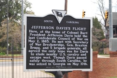
Jefferson Davis's Flight Marker
RANKED BY RELEVANCE
1 ► South Carolina, Abbeville County, Abbeville — 1-7 — Burt-Stark House / Jefferson Davis’s Flight —
On North Main Street (State Highway 71) at Greenville Street (State Highway 20) on North Main Street.
2 ► South Carolina, Abbeville County, Abbeville — The Last Meeting of the Confederate States Cabinet —
On Main Street at Greenville Street, in the median on Main Street.
3 ► South Carolina, Laurens County, Joanna — 30-1 — Jefferson Davis Flight
On SC Highway 56, on the right when traveling south. Reported missing.

4 ► Tennessee, Shelby County, Memphis — 37 — Grand Lake Cutoff/Worthington Cutoff/Kentucky Bend —
Near Riverside Drive.

5 ► Minnesota, Dakota County, Hastings — Native Cultures —
Near Lock and Dam Road 0.7 miles north of 2nd Street West, on the right when traveling north.
6 ► Texas, Travis County, Austin, Downtown Austin — 16141 — Moses Austin — (October 4, 1761 - June 10, 1821) —
On Congress Avenue just south of East 18th Street.

7 ► Alabama, Morgan County, Lacey's Spring — Lacey's Spring —
On U.S. 231 0.2 miles north of State Route 36, on the right when traveling north.
8 ► Iowa, Washington County, Crawfordsville — First Settler's Home in Washington County — Iowa 150 Celebrate Our State 1846 • 1996 —
On East Columbus Street just east of North Main Street, on the left when traveling east.

9 ► Alabama, Lee County, Smiths Station — Line 32° 28´ North Latitude —
On County Road 430 0.6 miles south of County Road 248, on the left when traveling south.
10 ► Alabama, Sumter County, York — Line 32° 28´ North Latitude —
On 4th Avenue (U.S. 11) 0.6 miles north of Longshore Drive, on the right when traveling north.
11 ► Texas, Washington County, Whitman — 18640 — Camp Felder —
On Farm to Market Road 1155 0.6 miles south of Farm to Market Road 2193, on the left when traveling north.

12 ► Alabama, Henry County, Abbeville — Abbeville / Seven Flags and an Arrow Over Abbeville —
On East Washington Street, on the right when traveling east.
13 ► Alabama, Washington County, Calvert — 8 — MOWA Band of Choctaw Indians — Mount Vernon History Trail —
On Red Fox Road 3.2 miles west of U.S. 43, on the right when traveling west.
14 ► Missouri, Washington County, Potosi — Potosi —
On West High Street (Missouri Route 8) at South Missouri Street, on the right when traveling east on West High Street.

15 ► Minnesota, Washington County, Stillwater — Minnesota Territory 1849 – 1858 / Washington County Takes Shape —
Near Walnut Street West, west of 3rd Street South, on the right when traveling west.
Paid Advertisement
16 ► Texas, Washington County, Burton — 8363 — Gideon Lincecum — (1793-1874) —
On Farm to Market Road 390 south of Longpoint Road, on the right when traveling west.

17 ► Maine, Washington County, Eastport — Cobscook Bay — Downeast Fisheries Trail —
On Maine Route 190 0.1 miles east of Kendall’s Head Road, on the right when traveling east.
18 ► Mississippi, Sunflower County, Inverness — 68 — Little Milton Campbell — Mississippi Blues Trail —
On East Grand Avenue 0.1 miles north of 2nd Street.
19 ► Virginia, Wythe County, Austinville — KD-5 — Fincastle County —
On Fort Chiswell Road (U.S. 520) just south of Austinville Road (County Route 619), on the left when traveling south.

20 ► Kentucky, Taylor County, Campbellsville — Confederate Artillery Position — Morning, July 4, 1863 —
On Tebbs Bend Road 0.3 miles west of New Columbia Road (Kentucky Route 55), on the left when traveling west.
21 ► Kentucky, Washington County, Springfield — Lincoln Homestead State Park —
On Beechland Road (Kentucky Route 438) at Lincoln Park Road ( Route 528), on the left when traveling east on Beechland Road.
22 ► Tennessee, Davidson County, Nashville, North Capitol — Walkway of the Counties / Mountains —
On 6th Avenue North, on the left when traveling north.

23 ► Oklahoma, Washington County, Bartlesville — Building the City of Legends —
On 4th Street at Dewey Avenue, on the right when traveling west on 4th Street.
 
    Thin black lines indicate changes in relevance. Between each pair of lines entries are ordered geographically but all have the same relevance.
* Inflectional forms of words are their plurals, singulars, and possessives as well as gramatical tenses and similar variations.
 
CeraNet Cloud Computing sponsors the Historical Marker Database.
This website earns income from purchases you make after using our links to Amazon.com. We appreciate your support.
Paid Advertisement
Nov. 13, 2026
