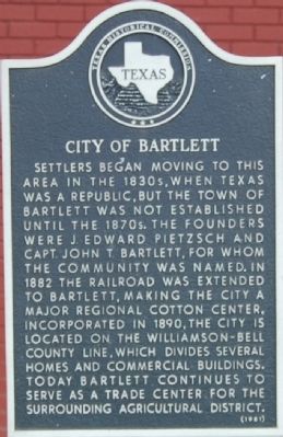
On W. Clark St., on the right when traveling west.
Settlers began moving to this area in the 1830s, when Texas was a Republic, but the town of Bartlett was not established until the 1870s. The founders were J. Edward Pietzsch and Capt. John T. Bartlett, for whom the community was named. In 1882 the . . . — — Map (db m29040) HM
On Donahoe Road at Post Oak Road, on the right when traveling north on Donahoe Road.
Colonists settled in the late 1840s along the fertile Donahoe Creek. Samuel Gibbs Leatherman (1799-1888) arrived in 1854 and opened the first mercantile store. He gave land for the cemetery and brought in the first doctor. In 1880 Leatherman donated . . . — — Map (db m29073) HM
Originally known as Pecan Grove Baptist Church, this fellowship was organized in 1873 by the Rev. M.V. Smith, the Rev. H.I. Kimball, and the Rev. G.W. Baines, great-grandfather of United States President Lyndon Baines Johnson. In 1884 the church was . . . — — Map (db m29036) HM
With overcrowded buildings at the African American school in southwestern Bartlett, the Bartlett trustees bought four buildings from Camp Swift in Bastrop to enlarge the facilities. A bond issue passed in 1948, and plans began for a U-shaped . . . — — Map (db m29037) HM
Established by German immigrants in 1880, the German-English School was an early school in the Bartlett area. First called Indian Creek School, the name was changed due to popular usage and the nature of instruction, which was in English during the . . . — — Map (db m29039) HM
The first Lutheran worship services in this area were held at the home of early German settler J.E. Pietzsch, who had moved from Austin County. In 1880 a small school and church building was erected on land donated by John Bartlett, for whom the . . . — — Map (db m29038) HM
On Stockton Rd, on the right when traveling north.
The Stockton Family Cemetery is located on land originally granted in 1859 by Texas governor Hardin R. Runnels to Moses Allen, a veteran of the Siege of Bexar. Douglas Hayden Stockton and his wife Mary Elizabeth (White) brought their family to Bell . . . — — Map (db m28455) HM
On W. Clark St., on the right when traveling west.
What began in 1902 as an idea to organize a women's club with a focus on literature and history became a reality in April 1903, with the formation of a Woman's Study Club. Chartered with nineteen members under the leadership of Mrs. Vena (Holzgraf) . . . — — Map (db m29041) HM
On Vann Circle west of College Street, on the left when traveling east.
Baylor University (including the "Female Department" later to become Mary Hardin-Baylor) had operated at Independence for 15 years before 1861. In the Civil War it suffered the setbacks of Texas education in general. This was despite leadership of . . . — — Map (db m152004) HM
On N Alexander Street north of W 3rd Ave, on the left when traveling north.
Bell County school districts were formed in 1854. The earliest record of public education for area African American students dates from 1882 when Mrs. Aleck McGee was hired "to teach the colored school." Professor Thomas Breckenridge Harris . . . — — Map (db m286918) HM
Settlement began on Lampasas River, 1847. Created Jan. 22, organized Aug. 1, 1850. Named for Peter Hansbrough Bell (1812-1898), native of Virginia; veteran of Battle of San Jacinto; served in Somervell expedition to stop Mexico's Raids into Texas; . . . — — Map (db m218643) HM
On Central Avenue near Main Street, on the left when traveling west.
Using arched passageways, round-arch and pedimented windows, a clock tower with columned gallery, and a rusticated limestone finish, Jasper N. Preston & Son of Austin designed the 1885 Bell County Courthouse in the Renaissance Revival style. Ben D. . . . — — Map (db m149423) HM
On South Main Street (State Highway 317) at Water Street, on the right when traveling north on South Main Street.
Three Bell County courthouses have stood on this site — part of the 120 acres given by Matilda F. Connell Allen for the location of the county seat.
Prior to erection of a courthouse, early official business of the county (created and . . . — — Map (db m201984) HM
The Belton Farmers Co-op Gin, built in 1927 along Nolan Creek, is a rare example of a surviving brick cotton gin in Central Texas. It was built by an association of local cotton farmers to replace an earlier gin that had burned down on the site in . . . — — Map (db m149427) HM
On North Pearl Street north of East 2nd Avenue, on the left when traveling north.
In 1867, Martha White McWhirter experienced a religious vision during which she felt she had been sanctified by God. She began to share her experience with other Belton women, and soon formed a small community of women who, desiring to leave their . . . — — Map (db m150602) HM
On East Central Avenue at North Blair Street, on the right when traveling west on East Central Avenue.
Captain Henry T. Waskow (1918-1943) of Belton was a company commander in the 36th Division. He joined the Texas National Guard, Company I, 143rd Infantry, 36th Division in 1935 and was called into active service in 1940. Beloved by his men, Waskow . . . — — Map (db m212167) HM
On South Penelope Street at East Central Avenue, on the right when traveling south on South Penelope Street.
Henry Mansfield Cook opened his first store in Centerville, Texas, in 1869, and in 1874 established the firm of H.M. Cook & Company with his son-in-law, Thomas W. Cochran. The firm moved to Buffalo, Texas, in 1876. Their mercantile business stocked . . . — — Map (db m150613) HM
On South Penelope Street north of Avenue F, on the right when traveling north.
The Confederate tradition in Bell County goes back to the War between the States itself. The citizens of Bell County were very pro-Southern in their opinions. Voters in Bell County overwhelming voted for Texas to leave the Union. In a state wide . . . — — Map (db m152300) HM
On Moore Avenue north of West Martin Luther King Jr Avenue, on the right when traveling north.
Noted lawmaker, judge, lay preacher, served in the legislatures of his native Kentucky and of Alabama. Represented Alabama in U.S. Congress, 1829-1831.
Came to Texas 1839. Was Associate Justice Supreme Court, Republic of Texas, 1840-1846. Judge . . . — — Map (db m152063) HM
On North Pearl Street south of West 2nd Avenue, on the right when traveling south.
In 1854, four years after the county was organized, a 2-story structure of logs was built on this site, to serve as the first Bell County jail. That log jail was replaced in 1873 by this building of native limestone.
In 1874, vigilantes from . . . — — Map (db m193835) HM
On North Main Street (State Highway 317) at West 5th Avenue, on the left when traveling north on North Main Street.
The First Baptist Church of Belton was organized in the summer of 1853 under the leadership of the Rev. Solomon G. O'Bryan and the Rev. David Fisher. There were eight charter members, and the congregation met in a small frame building on Pearl . . . — — Map (db m152233) HM
On North Church Street at Greenbriar Street, on the left when traveling north on North Church Street.
On October 21, 1860, the Rev. Levi Tenney established a Presbyterian congregation in Belton with eight founding members. After meeting in several locations during its early years, property was purchased west of the intersection of Second Ave. and . . . — — Map (db m286926) HM
Built in 1912 at the Santa Fe rail yards in Temple, this planing mill was part of a complex of buildings that housed repair facilities for the railroad. Workers at the mill manufactured replacement parts for wooden elements of the Santa Fe's boxcars . . . — — Map (db m29380) HM
On West 10th Avenue at University Drive, on the right when traveling west on West 10th Avenue.
State Senator, Confederate veteran, lawyer, teacher at Salado College. Birthplace of Harris' grandson, famous World War II General, Walton Harris Walker. Home was built in 1866 of limestone quarried nearby. Mortar contains . . . — — Map (db m286857) HM
On South Penelope Street at E Ave East on South Penelope Street.
San Jacinto Veteran born in Tennessee, 1814, died in 1858. His wife Amanda Isbell. Born April 8, 1819, died September 1, 1880. — — Map (db m286837) HM WM
On Vann Circle west of College Street, on the right when traveling west.
Born a slave in Kentucky, Jeff Hamilton was still a child when Sam Houston rescued him from purchase by a cruel master at a slave auction. Hamilton was Houston's personal servant during his term as governor, 1859-1861, and was at his bedside when he . . . — — Map (db m152118) HM
Near Taylors Valley Road 0.3 miles east of East 6th Avenue (Farm to Market Road 93), on the left when traveling east.
A Kentucky-born slave who was brought to Texas as a child, Jeff Hamilton became San Houston's personal servant, companion of his young sons, and a trusted member of his household. Hamilton served Houston while he was governor, 1859-1861, and until . . . — — Map (db m151036) HM
On East Central Avenue at North Wall Street, on the right when traveling west on East Central Avenue.
During World War II, Temple native Keifer Marshall, Jr. (1925-) served in the United States Marine Corps, 3rd Marine Division, 9th Regiment, F Company, 2nd Battalion, as a rifleman. During February and March of 1945, Marshall saw heavy combat on the . . . — — Map (db m212164) HM
On I-35 Frontage Rd, on the right when traveling south.
A stockade and blockhouse of the Republic of Texas. Built in November, 1836, by a unit of some 20 Rangers under Lt. George B. Erath (soldier-statesman for whom Erath County was named).
By Christmas they had erected 7 or 8 cabins, a blockhouse and . . . — — Map (db m29378) HM
On Vann Circle west of College Street, on the right when traveling west.
This memorial, an important symbol for the University of Mary Hardin-Baylor, has historic ties to the earliest days of the school in Belton. Founded in 1845 at Independence, Texas, as the female department of Baylor University, the school moved here . . . — — Map (db m286786) HM
On East Avenue E east of South Penelope Street, on the left when traveling west.
Widow of William Hardin
before her marriage to
Dr. O.P. Kelton
Many of the Mexican officers
and men were placed in the
care of Judge and Mrs. Hardin
after the victory at San Jacinto
and were mercifully treated by them.
Born August . . . — — Map (db m152194) HM
On South Main Street at West Avenue F, on the right when traveling south on South Main Street.
German immigrant Fred Muehlhause, Sr. (1868-1947) arrived in Texas in 1885. He married Louise Albrecht in 1892, and later that year the couple moved to a home located adjacent to this homesite. Muehlhause worked as a craftsman shoemaker and . . . — — Map (db m193834) HM
Near North Main Street (State Highway 317) north of East 15th Avenue, on the left when traveling north.
Texas revolutionary veteran and local merchant Norman Austin made important contributions to his adopted state. Born in Skaneateles, New York, he was the fifth son of a large family and traveled widely throughout his life. He farmed in Michigan and . . . — — Map (db m152240) HM
On East Central Avenue at North Wall Street, on the right when traveling west on East Central Avenue.
Honor ☆ Service ☆ Commitment
These are just a few of the core values of men and women who make up our Nation's armed services. Throughout the ages, these individuals swore an oath to protect and defend our Constitution and the . . . — — Map (db m212165) WM
On South Main Street at Water Street on South Main Street.
(right side)
Fought at San Jacinto April 21, 1836. Assistant Inspector General and Inspector General of the Texas Army 1837-1839. Captain of Texas Rangers and Lieutenant Colonel of Mounted Volunteers in the Mexican War 1845-1846. Colonel . . . — — Map (db m258922) HM
On West Martin Luther King Jr Drive east of Moore Street, on the right when traveling east.
The School of Nursing was founded in 1904 by Dr. Arthur C. Scott and Dr. Raleigh White, Jr., as a part of their Temple Sanitarium to provide professional training for nurses. Initially a small local student body was instructed by the doctors and . . . — — Map (db m152016) HM
On Water Street east of South Penelope Street, on the right when traveling east.
A large building erected here 1850, by Mrs. Sarah Lawler (1807-1890). In this structure, little more than a shed, Mrs. Lawler boarded workmen who were surveying and building Nolanville (later renamed Belton), county seat of newly-created Bell . . . — — Map (db m305381) HM
On North Main Street (State Highway 317) at West First Avenue, on the left when traveling north on North Main Street.
On this site of the Old Post Office on
July 14, 1857, Sam Houston, Commander
of the Texian Army and Hero of San Jacinto
spoke while running for governor.
After being past president of the Republic
of Texas and senator he served as governor . . . — — Map (db m152381) HM
On Water Street at South Penelope Street, on the right when traveling east on Water Street.
A Scotsman, Robert Naismith (1859-1938), founded the Central Manufacturing Co. in a two-story building on this lot in 1893. Using equipment originally powered by steam, he supplied and repaired machine parts for the Belton area. The company also did . . . — — Map (db m149431) HM
On South Penelope Street north of Avenue F, on the right when traveling north.
South Belton cemetery is located on Kinney Hill on the south side of Nolan Creek. Bell County and Belton were formed in early 1850. The cemetery was established soon after. The oldest remaining marked death date is May 21, 1851, when Elizabeth . . . — — Map (db m152297) HM
On North Main Street (State Highway 317) at East First Ave, on the right when traveling north on North Main Street.
Completed in 1904, this brick library building was funded by a personal contribution from the noted New York industrialist and benefactor Andrew S. Carnegie. Ben D. Lee, builder of the Bell County Courthouse, served as contractor. Designed by the . . . — — Map (db m152196) HM
On South Main Street at W Ave E, on the left when traveling north on South Main Street.
Built in the early 1890s, this house was deeded by prominent Belton businessman Peter Hammersmith to his son, John Peter, as a wedding gift in 1895. The property was sold to Sophie Clark, widow of a Rogers lumberman, in 1899. During World War II, . . . — — Map (db m286833) HM
On North Main Street at W 10th Ave, on the left when traveling north on North Main Street.
W.R. and Ida (Rogers) Miller, rich from good cotton years at turn of the century, built this late Victorian house in 1902. In its architecture, Queen Anne features are mingled with Shingle style then popular in the eastern U.S. The design included . . . — — Map (db m286834) HM
On North Main Street at W 10th Ave, on the left when traveling north on North Main Street.
Cotton broker William Ray Miller (1868-1954) and his wife Ida (Rogers) built this structure in 1902 and lived here with their large family about six years. Mrs. Miller was from Galveston, and had graduated from Baylor College (now Mary . . . — — Map (db m286835) HM
On East 9th Avenue at North Wall Street, on the right when traveling west on East 9th Avenue.
A distinctive Victorian house, associated with one of the historic private schools of Bell County. Charles H. Wedemeyer (1857-1938), a former teacher and administrator of Baylor University, Crane College, and Waco University, moved here with his . . . — — Map (db m286907) HM
On West Central Avenue at North Pearl Street, on the right when traveling west on West Central Avenue.
A native of Tennessee, William W. Reed came to Texas with his parents, Michael and Martha Reed, in 1833 and joined Robertson's colony in 1834. His land grant was situated near his parents' land on the south bank of the Little River. The family . . . — — Map (db m150627) HM
A native of South Carolina, Wilson Van Dyke served as a member of the Somervell Expedition, which was organized in 1842 to expel the Mexican Army from Texas. Under command of Col. W.S. Fisher, he crossed the Rio Grande and was captured. A survivor . . . — — Map (db m29382) HM
On North Main Street (State Highway 317) at East First Ave, on the right when traveling north on North Main Street.
Founded in 1898 as a literary society with twenty-five members, the Woman's Wednesday Club is the oldest active club of its kind in Bell County. Initially meeting in the Central Hotel in downtown Belton, the club members were devoted to the study of . . . — — Map (db m152232) HM
The M1 Abrams Main Battle Tank (MBT) is a fully tracked, low silhouette, land combat assault weapons system. It is named for General Creighton Abrams, whom Maj. Gen. George Patton called "the best tank commander in the Army" during World War . . . — — Map (db m304657) HM
On West Travis Street at North Lexington Street, on the right when traveling east on West Travis Street.
Present-day Holland has its origins in three different settlements. Settlers first came here during the 1830s to farm the area’s fertile soil. A community named Mountain Home (0.5 mi SE) formed along Darrs Creek and included a school, church, . . . — — Map (db m75700) HM
On Farm to Market Road 1123 0.2 miles west of Roberts Road, on the right when traveling west.
The only physical remnant of the Post Oak community, this cemetery began as the burial ground for the family of Isham McMillin, who acquired land in this part of Bell County in 1855. The oldest marked grave, that of McMillin’s daughter Elizabeth, . . . — — Map (db m89692) HM
On W. Travis Street (Farm to Market Road 2268) east of Austin Street, on the right when traveling east.
On January 14, 1914, a small group of local women met to organize a study club for the cultural advancement of its members. In addition to its primary focus, the club soon adopted a series of civic projects, including many that offered financial . . . — — Map (db m89893) HM
On S. Fort Hood Street (State Highway 195) 0.1 miles south of Viola Drive.
Front
1SG Bobby Mendez STB, 2BCT 27 Apr 2006 •
CPL Robbie G. Light 1-67 AR 1 May 2006 •
CPT Shane Mahaffee 489th CA 5 May 2006 •
MSG Carlos Saenz 490th CA 5 May 2006 •
SGT Nathan J. Vacho 489th CA 5 May 2006 •
SPC Teodoro Torrer . . . — — Map (db m304659) WM
On S. Fort Hood Street (State Highway 195) 0.1 miles south of Viola Drive.
Dedicated to All Veterans of Central Texas who served our country with eternal honor and valor, sacrificing all for every American. — — Map (db m304660) WM
On S. Fort Hood Street (State Highway 195) 0.1 miles south of Viola Drive.
AmVets Department of Texas and Amvets National Service Foundation dedicated this Memorial Carillon as a living memorial to America's veterans who served their country honorably for the cause of freedom.
"...As these bells ring... Honored dead . . . — — Map (db m305083) WM
On North College Street at West Avenue D, on the right when traveling south on North College Street.
Constructed to replace an earlier brick schoolhouse destroyed by fire, the present Avenue D School was built in 1923. C.J. Leinbach of Dallas designed the three-story building, which features decorative stonework and separate entrances for girls and . . . — — Map (db m117551) HM
On South Gray Street 0.1 miles north of Long Avenue, on the right when traveling north.
Bethel Primitive Baptist Church originated in the Palo Alto Community, which was located about 3.5 miles northeast of present Killeen. Organized about 1864, the congregation met in a Union Church building shared with other denominations.
When . . . — — Map (db m234566) HM
On Traverse Drive at Haven Drive, on the right when traveling west on Traverse Drive.
Although this cemetery is the last remnant of the Blackburn Estate, it gives visitors a glimpse of the history of a long line of Texans who served in many wars and once owned land that now makes up part of Fort Hood. John Porter Blackburn, veteran . . . — — Map (db m287756) HM
On Conder Street at Sutton Drive, on the left when traveling south on Conder Street.
When the tracks of the Gulf, Colorado and Santa Fe Railroad were extended from Temple to Lampasas in the early 1880s, a switching station was installed near the midway point. The settlement that grew up around the site became the town of Killeen, . . . — — Map (db m133597) HM
On South W S Young Drive south of Little Nolan Road, on the left when traveling south.
This bell was cast in the C.S. Bell and Company Foundry in Hillsboro, Ohio between 1889-1892. It was placed in the first tower of the church in 1905 following other building programs of the church it was placed in the bell tower of Clements Chapel . . . — — Map (db m287764) HM
On S. Fort Hood Street (State Highway 195) 0.1 miles south of Viola Drive.
OIF 1
SPC Wilfredo Perez Jr. 26 Jul 03 HHC •
SGT Daniel K. Methvin 26 Jul 03 HHC •
SPC Jonathan P. Barnes 26 Jul 03 HHC •
CPT George A. Wood 20 Nov 03 B Co.
OIF 05 - 07
CPL Aaron M. Forbes 28 Dec 05 E Co •
CPL Scott M. Bandhold . . . — — Map (db m304842) WM
On South W S Young Drive south of Little Nolan Rd, on the left when traveling south.
This fellowship was established in 1873 as the Baptist Church of Christ at Palo Alto. In 1883, one year after Killeen was founded on the rail line, the congregation moved three miles southwest to the new town. The Rev. Thomas H. Bacon served as . . . — — Map (db m287763) HM
On North Gray Street at East Avenue B, on the left when traveling north on North Gray Street.
Chartered on Feb. 27, 1901, the First National Bank of Killeen is the oldest continuously operated bank in Bell County. It first served a primarily agricultural economy, but as Killeen began to develop the bank led in the town's dramatic growth. Its . . . — — Map (db m133596) HM
On Old FM 440 Road 0.1 miles south of Ronstan Drive, on the right when traveling south.
The first burial in this graveyard, that of Wilhelm Wolf, took place in 1891, two years after the German Evangelical Lutheran Emmanuel Congregation was formally organized. The Rev. H.F. Daude (1850-1924), who served as first pastor, deeded land here . . . — — Map (db m121279) HM
On North 4th Street at E Avenue D, on the left when traveling north on North 4th Street.
James H. "Screwdriver" Arnold, a native of Killeen, son of Jim and Velma Arnold, a farming family in the community.
Arnold graduated from Killeen High School in 1935, and worked as a plumber during the following years prior to entering the . . . — — Map (db m287768) HM WM
On East Veterans Memorial Boulevard (Business U.S. 190) at S W S Young Drive, on the right when traveling west on East Veterans Memorial Boulevard.
John Churchill Gaines Blackburn (1832-1912) was born in Tennessee and came to Texas in 1853. He and his wife Mary Ann Chambers Blackburn (1831-1908) first stopped with other family members in Williamson County, then moved to Bell County in 1854. . . . — — Map (db m287762) HM
On Florence Road 0.1 miles south of Dubroc Drive, on the right when traveling south.
W.E. Bennett began publishing the Killeen Herald in June 1890, eight years after the town of Killeen was founded. Later owners of the newspaper included W.T. Carter, an active civic leader who served as publisher and editor from 1907 to 1950. Begun . . . — — Map (db m121286) HM
On N College Street at West Avenue D, on the left when traveling north on N College Street.
On this site stood Killeen's first brick school, a Richardsonian Romanesque building. Constructed in 1902-03 and facing the railroad, Killeen's link to the world. The building was destroyed by fire on March 15, 1923, and replaced by the present . . . — — Map (db m287770) HM
On Live Oak Cemetery Road 0.1 miles west of Acorn Ln, on the left when traveling west.
Although an inventory of marked gravesites indicates that the first person buried here was Michael Young, local tradition claims that distinction actually belongs to Young's daughter. She is believed to have died of sickness near this location . . . — — Map (db m304740) HM
On Wolfridge Road 0.4 miles east of Maxdale Road (Farm to Market Road 2670), on the right when traveling east.
Established in the 1860s to serve the rural community of Pleasant Grove, this cemetery is one of the oldest in Bell County. Land for the graveyard was given by Frank N. McBryde, Sr., whose 1883 application for a post office for the community . . . — — Map (db m121241) HM
On State Highway 195 0.2 miles north of Sharp Cemetery Road, on the right when traveling north.
Mancel T. McBryde (1821-1896), who brought his family here from Georgia in the early 1860s, began this family cemetery in 1885 upon the death of his wife, Jane W. Goar McBryde (1826-1885). A farmer and rancher, McBryde selected a site south of his . . . — — Map (db m121235) HM
On North College Street at 761st Tank Battalion Ave, on the left when traveling north on North College Street.
Oveta Culp Hobby served as the director of the Women's Army Corps (WAC) during World War II. Her organizational skills and leadership helped make the WAC a respected part of the American military and opened new possibilities for women in U.S. . . . — — Map (db m288758) HM
On Santa Fe Plaza Drive at N 4th Street, on the left when traveling east on Santa Fe Plaza Drive.
Founded in 1882 as a shipping point on the Gulf, Colorado, and Santa Fe Railroad, Killeen was named for railroad official Frank P. Killeen. After the first depot was destroyed by fire, Santa Fe workers used standard plans to build this structure in . . . — — Map (db m287765) HM
On Sharp Cemetery Road 1.8 miles east of State Road 195.
Emily Leseur Haynes Sharp (1824-1880) came to Texas from Alabama with her first husband, William Glenn Haynes. They settled in Harrison County, where they owned a large amount of land and operated a cotton gin. William Haynes died in 1849, and . . . — — Map (db m304739) HM
On S. Fort Hood Street (State Highway 195) 0.1 miles south of Viola Drive.
Dedicated to all members of the U.S. Army Special Forces, the 1st Special Service Force, and the OSS of World War II, "The Green Berets," who made the ultimate sacrifice in Europe, Southeast Asia, Central America, and Southwest Asia for . . . — — Map (db m304859) WM
On S. Fort Hood Street (State Highway 195) 0.1 miles south of Viola Drive.
"The country that sent us off to war was not there to welcome us home," stated by H. Moore and J. Galloway and sums up what occurred to many Vietnam Veterans.
In 2008 Congress passed Public Law 110-181§589 authorizing the Secretary of Defense . . . — — Map (db m304892) WM
On Florence Road at Rhonda Street, on the right when traveling north on Florence Road.
Organized by twelve charter members in September 1906, this organization was originally known as the Ladies Literary Society of Killeen. The name was changed one month later to the Wednesday Review Club. Pursuing studies in American and . . . — — Map (db m121291) HM
On S. Fort Hood Street (State Highway 195) 0.1 miles south of Viola Drive.
To Honor All Women Who Have Served Our Country
Right Side
Preamble
We, the members of the Women's Army Corps Veterans' Association, humbly petition the blessings of our Heavenly Father upon all our activities that we may grow . . . — — Map (db m304862) WM
On W Main Street (Farm to Market Road 436) at Wilson Valley Road, on the right when traveling west on W Main Street.
Site of a picket fort on Little River commonly called Fort Griffin; also known as Fort Smith and Little River Fort. Erected by Geo. B. Erath and 20 Texas Rangers in November, 1836 as a protection against Indians. Abandoned as a military post . . . — — Map (db m286836) HM
On Wilson Valley Loop at Wilson Valley Road on Wilson Valley Loop.
Wilson Valley community originally consisted of the seven Wilson brothers, their wives and children, and the Huckabee and Thornton families. They came from Mississippi in 1867 to escape Civil War devastation.
According to family tradition, . . . — — Map (db m286920) HM
Break in mountain chain from Lampasas River to Nolan Creek. Route to one of oldest Indian trails in Southwest, and escape point for Comanches after last raid in Bell County. On March 14-16, 1859, the Indians killed four settlers, including John . . . — — Map (db m174960) HM
On South Main Street 0.1 miles west of Biles, on the right when traveling east.
In 1889 five families met under a brush arbor to form the Nolanville Church of Christ and within a month had purchased land at this site on which to build a permanent church. That first meeting led to 106 consecutive summer camp meetings dedicated . . . — — Map (db m175096) HM
On Old Nolanville Road west of Wilderness Basin, on the left when traveling west.
Pioneers who settled this area in the early 1850s built a 1-room log schoolhouse about 1854. That year Bell County was divided into 15 school districts. Nolanville School moved to several different sites in the area. In 1928-29 the last high school . . . — — Map (db m289965) HM
On Pleasant Hill Road 0.3 miles north of N Central Texas Expy (Feeder), on the left when traveling north.
This cemetery is one of the oldest in Bell County, established around 1855 on land donated by Fleming T. Cox to serve the Nolensville community. The earliest known grave is that of J. Carmack around 1855.
In addition to pioneer settlers, many . . . — — Map (db m288761) HM
On Pleasant Hill Road 0.3 miles north of N Central Texas Expy (Feeder), on the left when traveling north.
Pleasant Hill Cemetery has served the citizens of this area since 1855 and is one of the oldest cemeteries in Bell County. The first person to be interred at the site was J. Carmack (d. 1855). Carmack was buried on the farm of pioneer settler . . . — — Map (db m288759) HM
1210 entries matched your criteria. Entries 101 through 200 are listed above. ⊲ Previous 100 — Next 100 ⊳