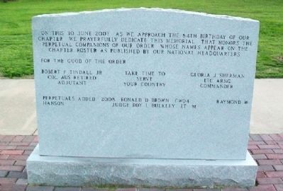
Is hereby organized and instituted as a chapter of the Order to be known as the Topeka Chapter of the Military Order of the World War. Chartered this 30th day of August in the Year of our Lord One Thousand Nine Hundred and Twenty-Three
S added to . . . — — Map (db m48457) HM
Former students who gave their lives
in the World War 1917 - 1918
Victor Blakely • Robert Melton
William Bolinger • Harold Olson
Crosby Deacon • Lyman Rice
Kenneth Sutherland — — Map (db m50786) HM
This memorial is given as a
tribute for those who worked
unselfishly in restoring our
city to normalcy, and as
a memorial to those who
lost their lives in the
tornado of June 8, 1966.
Lisle Grauer • Mary Beasley
Craig Beymer • . . . — — Map (db m47334) HM
Kansas is a land of trails. Even before Kansas became a state in 1861, many people and animals traveled through the area. It is the north-south route for migratory birds. Elk and bison cut paths looking for rivers and other water sources. Native . . . — — Map (db m48660) HM
Memorial Court of Honor
in memory of those who
have served their country
in the sacred cause of
liberty and justice
Veterans of All Wars
at rest in Mount Hope
[Honor Roll of Veterans]
Brave Men and Worthy Patriots
dear to . . . — — Map (db m73459) WM
The Victor Common Schoolhouse, District #101, was used from 1881-1954 in Rossville, Kansas. The first teacher at this one-room school had 20 students and was paid $30 per month. Besides teaching, the teacher also served as the school nurse and . . . — — Map (db m64978) HM
Anthony A. Ward bought land from Indians - 1854. Site of first sermon preached in Topeka, December 29, 1854.
——————————
Entered on the
National Register
of Historic Places . . . — — Map (db m65038) HM
Anthony Ward constructed this home between 1870 and 1874. Two sides are built of handsome brick and two of native limestone. The house was remodeled between 1900 and 1905 after it was occupied by the Ward's daughter, Jennie Ward Meade and her . . . — — Map (db m65037) HM
"Ad Astra per Aspera," to the stars through difficulties, is the state motto and exemplifies the aspirations of the people of Kansas. The significance of this attitude has been incorporated into the development of the Capitol dome sculpture. The . . . — — Map (db m287559) HM
The sculpture of "Ad Astra" was installed in October 2002. After 113 years of failed efforts to place a sculpture atop the Capitol dome. Not until the unwavering support of Governor Bill Graves, who believed that the Capitol building of the state . . . — — Map (db m287561) HM
The Chouteau family of St. Louis had enjoyed a major share of the Kansa trade since the early nineteenth century. Although Kansa trad had in recent years been on the decline, the Chouteaus found a renewed interest in the Kansas after the tribe . . . — — Map (db m287525) HM
The Ad Astra sculpture on the Capitol dome was dedicated on Monday, November 4, 2002.
The ceremony began with the blessing of the sculpture by Badger Wahwassuck of the Potawatomi Nation. Anna Bergen-Kamerer, granddaughter of the sculptor, . . . — — Map (db m47003) HM
This property, formerly Hayden High School, is part of the Church of the Assumption Historic District, listed on the National Register of Historic Places — — Map (db m282181) HM
Bernard Frazier's bas relief sculptures were applied to three facades of the State Office Building. Carved from Indiana limestone, they portrayed early Kansas history contrasting with the Modern Movement architecture. He worked from summer 1956 . . . — — Map (db m287566) HM
In the year of our nation's
Bicentennial
1976
This flagstaff was raised as a constant
reminder of the principles on which this
country was founded and this company can grow — — Map (db m282252) HM
Kansa Indians belong to the Dhegiha branch of the Siouan-speaking peoples. The Dhegiha Siouan group consists of the Kansa, Osage Ponca, Kwapa (Quapaw) and Omaha tribes. Kansa legends suggest that these five tribes once lived together as one . . . — — Map (db m282336) HM
The first Spanish explorers arrived in Kansas in 1541, followed by Lewis and Clark in 1804. Westward migration brought the first white settlers - government agents in 1808 and missionaries in 1825. Oil and gas were discovered in 1851. In 1854, . . . — — Map (db m46995) HM
President Harry S. Truman introduced an Independence Savings Bond Drive in 1950 to boost defense funds and preserve freedom in the post-World War II era. The drive included sending 57 Liberty Bell replicas to each of the 48 states in the nation . . . — — Map (db m287569) HM
In accordance with the 1859 treaty, the government gave every indication that the Kansas were to remain in the Neosho Valley. Contracts to construct permanent houses, a manual-labor school, and new agency headquarters were awarded.
Yet this . . . — — Map (db m287548) HM
Following the treaties of 1825, the U.S. government expected the Kansa Indians, under the watchful eye of Indian bureau agents, to abandon hunting, trapping, and intertribal warfare, and instead become farmers. Several factors worked against the . . . — — Map (db m287524) HM
European fur trade in the sixteenth and seventeenth centuries, increasing demand for fur products in western europe led to a critical shortage. This shortage coincided with European occupation of much of North America, whose forests and rivers . . . — — Map (db m282345) HM
On April 18, 1796, the U.S. government legislated the government factory system for e conduct and regulation of the fur trade. By this means, the U.S. government hoped to eliminate the influence of private traders, counteract the actions of . . . — — Map (db m287510) HM
As the Kansas migrated westward, their style of lodging changed from timber based to sod based. Repeated relocation of core villages as well as the indiscriminate timber-cutting practices of white squatters ultimately forced the Kansas to rely . . . — — Map (db m282341) HM
The 256,000-acre reservation selected in 1846 as the "permanent" home for the Kansa Indians included Council Grove. Located in the Neosho Valley on the banks of the Neosho River, the area possessed rich soil and abundant timber. Not surprisingly, . . . — — Map (db m287547) HM
Bernard Frazier's bas relief sculptures were applied to three facades of the State Office Building. Carved from Indiana limestone, they portrayed early Kansas history contrasting with the Modern Movement architecture. He worked from summer 1956 . . . — — Map (db m287568) HM
Dedicated by the grateful citizens of the State of Kansas in honor of those Gold Star Families who sacrificed a loved one for our liberties and freedom — — Map (db m282209) WM
Dedicated to the citizens of Kansas who have served, are serving, and will serve in the Armed Forces of the United States and the State of Kansas — — Map (db m282214) WM
With the vision of universal freedom
for all mankind
this tree is dedicated to
Maj Bruce Johnson
and all
Prisoners of War
and
Missing in Action — — Map (db m282210) WM
This beautiful native stone building was originally known as the Brandt Hotel. For many years this hotel was host to many salesmen, politicians, and travelers visiting Alma. — — Map (db m64850) HM
This fine stone building was at one time a bawdy saloon of the early days and then served as a formal, dignified bank. A large arched wine cellar beneath it is still preserved in its original state. — — Map (db m64861) HM
Discovered by
Coronado 1541
———————
Rediscovered by
J.V. Brower 1896
Erected by
John T. Keagy
for
Quivira Historical Society
1904 . . . — — Map (db m64873) HM
This beautiful and stately native stone building was once one of the finest buildings in town. Being named after the two Irish brothers who built it, it is referred to as the Limerick Building. — — Map (db m64849) HM
This stone building was built by Mr. Conrad Mueller and operated as a saloon until Prohibition. He then started a hardware business. — — Map (db m64859) HM
Originally known as the Palenske Building, this beautiful two story stone building originally housed a bookstore. It was also a bank at one time. The detailed scrollwork around the doorway adds a unique touch to this building. — — Map (db m64877) HM
This brick building, made possible by donated labor and funds raised by the American Legion and Auxiliary Post #32, was built as a memorial to the Soldiers and Sailors of Wabaunsee County. — — Map (db m64851) HM WM
The 1867 law abolishing the open range provided for payment of 40 cents per rod (16½ ft.) to landowners to build and maintain a 4½ ft. stone fence. Stone was plentiful and our pioneers built miles of fences. — — Map (db m64885) HM
In 1884 this stone was used to construct the Machine Shop on the Strasen Farm. In 2008 the stone was donated for this wall in memory of Althea and Edgar Strasen by the Jim Johnson family. — — Map (db m64876) HM
Both the Wabaunsee County Bank and C.O. Kinne and R.J. Kerans General Merchandise store occupied this ornate native stone building at one time. — — Map (db m64858) HM
Erected by the Pupils of the Wabaunsee County Schools in honor of all our boys who entered the World War and in loving memory of those who made the supreme sacrifice.
Died in Service
Elmer Bartell • Dwight E. Bullock • John Carey • Edward . . . — — Map (db m64875) WM
Bluestem in the Flint Hills
"Texas shipped up the horns," Kansas cowmen used to say, "and we put the bodies under them." They meant that bony steers from Texas grew fat in the Bluestem pastures of Kansas. Stockmen drove their herds here . . . — — Map (db m73107) HM
When Kansas territory was opened for white settlement on May 30, 1854, a bitter contest developed over the slavery question. Established the following December, Topeka, 25 miles ahead, favored the Free-State cause even though the territorial . . . — — Map (db m55359) HM
151 entries matched your criteria. Entries 101 through 151 are listed above. ⊲ Previous 100