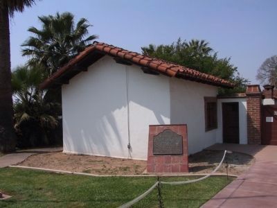
On Barton Road east of Nevada Street, on the right when traveling west.
This branch of San Gabriel Mission was constructed about 1830 on the San Bernardino Rancho. During the 1840's, its buildings were used by José del Carmen Lugo as part of his rancho grant. Later, after its sale to the Mormons, it was occupied by . . . — — Map (db m131701) HM
Near North University Street, on the right when traveling south.
Spanish missionaries introduced the principle of irrigation in San Bernardino Valley, thus opening the way to settlement. Franciscan Fathers engineered, and Native Americans dug, this first ditch, or "zanja", in 1819. It supported the San . . . — — Map (db m143344) HM
On Kentucky Street at Dunlap Boulevard, on the right when traveling east on Kentucky Street.
Constructed in 1842 by Diego Sepulveda, nephew of Antonio Maria Lugo, this is believed to be the oldest house in San Bernardino County. The land, formerly controlled by San Gabriel Mission, was part of Rancho San Bernardino, granted to the Lugos in . . . — — Map (db m143658) HM
On Big Bear Boulevard (Route 18) 0.1 miles east of North Shore Drive (Route 38).
In 1884 Frank Brown built an unusual dam here to supply irrigation water for the Redlands area. The single-arch granite dam formed Big Bear Lake, then the world’s largest man-made lake. Engineers claimed the dam would not hold, and declared it “The . . . — — Map (db m128510) HM
On Needles Highway 0.1 miles south of Aha Macav Parkway, on the right when traveling north.
This boundary monument, a cast iron column erected in 1873, marks the southern terminus of the California – Nevada State Boundary established by A. W. Von Schmidt's 1872 – 73 survey. Von Schmidt's line, the first officially recognized oblique state . . . — — Map (db m29467) HM
On South Knott Avenue, on the right when traveling north.
For more than half a century, the Pacific Electric Railway served Southern California. The system was established by Henry Huntington in 1895 and linked Los Angeles, Orange, Riverside, and San Bernardino counties with over 1,000 miles of service and . . . — — Map (db m101471) HM
On Knott Avenue, on the right when traveling south.
For more than half a century, the Pacific Electric Railway served Southern California. The system was established by Henry Huntington in 1895 and linked Los Angeles, Orange, Riverside, and San Bernardino counties with over 1,000 miles of service and . . . — — Map (db m101472) HM
On Holder Street, on the right when traveling north.
For more than half a century, the Pacific Electric Railway served Southern California. The system was established by Henry Huntington in 1895 and linked Los Angeles, Orange, Riverside, and San Bernardino counties with over 1,000 miles of service and . . . — — Map (db m101470) HM
On Lincoln Avenue, on the right when traveling east.
For more than half a century, the Pacific Electric Railway served Southern California. The system was established by Henry Huntington in 1895 and linked Los Angeles, Orange, Riverside, and San Bernardino counties with over 1,000 miles of service and . . . — — Map (db m101467) HM
On Moody Street, on the right when traveling south.
For more than half a century, the Pacific Electric Railway served Southern California. The system was established by Henry Huntington in 1895 and linked Los Angeles, Orange, Riverside, and San Bernardino counties with over 1,000 miles of service and . . . — — Map (db m101468) HM
On Valley View Street, on the right when traveling north. Reported missing.
For more than half a century, the Pacific Electric Railway served Southern California. The system was established by Henry Huntington in 1895 and linked Los Angeles, Orange, Riverside, and San Bernardino counties with over 1,000 miles of service and . . . — — Map (db m101469) HM
On Trask Avenue, on the right when traveling east. Reported missing.
For more than half a century, the Pacific Electric Railway served Southern California. The system was established by Henry Huntington in 1895 and linked Los Angeles, Orange, Riverside, and San Bernardino counties with over 1,000 miles of service and . . . — — Map (db m101475) HM
On West Cerritos Avenue, on the right when traveling east.
For more than half a century, the Pacific Electric Railway served Southern California. The system was established by Henry Huntington in 1895 and linked Los Angeles, Orange, Riverside, and San Bernardino counties with over 1,000 miles of service and . . . — — Map (db m101473) HM
On East 6th Street (Kansas Route 9) at Lincoln Street (U.S. 81), on the right when traveling east on East 6th Street.
Anna was the daughter of William Kinslow and Kitty Doherty of Connecticut. Kitty gave birth to her daughter in Manhattan, New York, and placed her daughter in the New York Foundling Hospital (NYFH). Anna was a part of a company of 40 children sent . . . — — Map (db m185872) HM
On Agua Mansa Road 0.2 miles east of Riverside Avenue, on the left when traveling east.
This historic site marks the resting place of the pioneers of the Agua Mansa area which was started about 1840. The preservation of this cemetery began in 1951. — — Map (db m127364) HM
On 5 Mile Road west of Interstate 40, on the left when traveling west.
The Evolution of Route 66
Commissioned in 1926 and dubbed the "Mother Road," Route 66 linked Chicago and Los Angeles - a highway of hope that led thousands of people to a new life in the West.
In 1926, less than half of Route 66 was . . . — — Map (db m201747) HM
On Lanfair Road at Goffs Road, on the right when traveling south on Lanfair Road.
Pah-Ute Creek, which runs year around, attracted many Indian tribes, who used several Indian trails through this area. The first white man to visit Pah-Ute Creek was Fr. Francisco Garces in May of 1776. It was given it's name by Lt. A.W. Whipple . . . — — Map (db m78577) HM
Near East Burdick Expressway (Business U.S. 2) at 13th Street Southeast, on the right when traveling west.
Langdon, North Dakota 1867-1936 Company H, 1st North Dakota Volunteer Infantry, U.S. Army On May 16, 1899, near San Isidro, Philippine Islands, Private Ross and 21 other scouts encountered an enemy force of approximately 600 men entrenched on the . . . — — Map (db m240628) HM
Near Vetter Mountain Road 2 miles west of Angeles Crest Highway (California Route 2).
Welcome to the Vetter Mountain Fire Lookout Tower in the Angeles National Forest. As you can see from the spectacular vistas, Vetter Mountain is an ideal location for a fire lookout.
The Vetter Mountain Lookout was constructed in 1937 and . . . — — Map (db m201274) HM
On National Trails Highway (Route 66) near Amboy Road, on the right when traveling east.
Albert Okura, a third-generation Japanese-American, was born and raised in Southern California during the
Baby Boom era. Growing up during the economic boom in the United States after World War II, he
considered himself a proud American who . . . — — Map (db m263606) HM
On Olive Street 0.2 miles east of 1st Street. Reported missing.
The Oro Grande Cemetery is one of
the oldest in the Victor Valley area
and was originally established as the
Bennette Memorial Park sometime around
1890. Mr. Bennette was a rancher who
raised stock in and around Oro Grande
up until 1894. . . . — — Map (db m245841) HM
Near Agua Mansa Road 0.2 miles east of Riverside Avenue, on the left when traveling east.
Louis Robidoux was the best known Ranchero in the Inland Empire
of his time. Louis and his wife Guadalupe Garcia Robidoux
had nine children;
Catalina, Louis Jr., Pasquel, Carmalita Adalaid, Marie Benina, Catarina
Abundo and Mariano, who died . . . — — Map (db m248009) HM
On North Arrowhead Avenue, on the right when traveling north. Reported missing.
(top-center plaque)
In March 1851 Charles C. Rich and Amasa M. Lyman, apostles of the Church of Jesus Christ of Latter-Day Saints, left Utah with 437 people "to establish a stronghold for the gathering of saints in California." Jefferson . . . — — Map (db m120645) HM
Welcome to Oro Grande Cemetery! The Oro Grande area has been occupied by people for centuries. In fact, close by, archaeologists found ancient footprints frozen in time next to the river wash.
Serrano people established a late-period native . . . — — Map (db m288417) HM
Thin black lines indicate changes in relevance. Between each pair of lines entries are ordered geographically but all have the same relevance.
* Inflectional forms of words are their plurals, singulars, and possessives as well as gramatical tenses and similar variations.