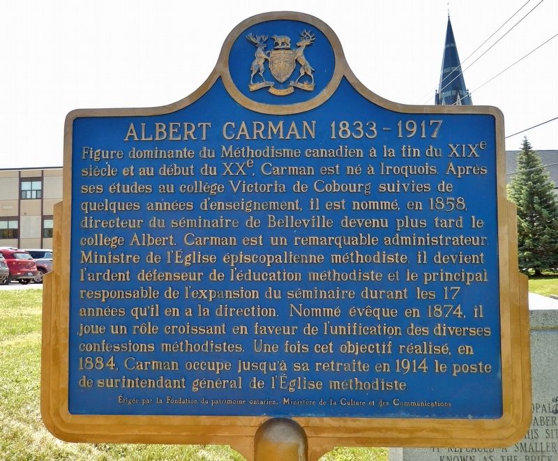
On Church Street 0.2 kilometers north of Victoria Avenue, on the right when traveling north.
[English] A commanding figure in Canadian Methodism during the late 19th and early 20th centuries, Carman was born in Iroquois and educated at Victoria College, Cobourg. He worked briefly as a teacher and was then . . . — — Map (db m255699) HM
On South Front Street at Harbour Drive, on the right when traveling north on South Front Street.
The Belle of the Bay While United Empire Loyalists are given credit for establishing the present community of Belleville at the mouth of the Moira River, there is evidence that the river was a transport route for natives and there are some . . . — — Map (db m262544) HM
Near South Front Street just south of Dundas Street East (Provincial Highway 62).
By 1790 the mill, tavern and stores established here near the Bay of Quinté had stimulated the growth of a settlement. Named “Belleville” in 1816, the village progressed steadily as a milling and shipping centre, and in 1834, the thriving community . . . — — Map (db m255695) HM
On Front Street just north of Market Street, on the right when traveling north.
[English] This imposing structure was erected in 1872-73 to house the public market and administrative offices of the rapidly expanding municipality of Belleville. It was designed by John Evans, a local architect, . . . — — Map (db m260657) HM
On Church Street at Patterson Street, on the right when traveling north on Church Street.
Belleville Collegiate Institute and Vocational School, the city's only public high school for over a quarter of a century, stood on this site on land set aside for educational purposes in the municipality's original town plan in 1816. The . . . — — Map (db m262551) HM
On Station Street (Provincial Highway 37) just east of Dafoe Street, on the left when traveling east.
[English] Meyers gained fame as a loyalist spy during the American Revolution. He recruited soldiers, gathered intelligence, and carried dispatches through enemy lines for the British army in his native New York. . . . — — Map (db m255607) HM
On Bridge Street East just east of Dufferin Avenue, on the right when traveling east.
It is essential to protect the commemorative architectural features of Glenmore National Historic Site for all Canadians, now and in the future. After more than a century of exposure to the elements, the built-in gutter system and slates were badly . . . — — Map (db m255917) HM
On Front Street just south of Upper Front Street Bridge, on the right when traveling south.
In 1867 contractor John Forin built this stone building with brick façade to house a fire station, police office and cells. Belleville Town Council met here until 1873. In 1916 a permanent firefighting force replaced volunteers. Firemen were on . . . — — Map (db m262268) HM
On Church Street just north of Bridge Street East, on the left when traveling north.
[English] The largest Protestant denomination in Canada during the late 19th and early 20th centuries, the Methodist Church (Canada, Newfoundland, Bermuda) was established in 1884. Its formation marked the . . . — — Map (db m255697) HM
Near Front Street at Market Street, on the left when traveling north.
Wolf Tausendfreund served the City of Belleville as a Councillor, valued citizen and later as a Superior Court Judge. During his 15-year tenure as a Councillor, Wolf strived for community improvement and wellness initiatives. As a Councillor, he . . . — — Map (db m262514) HM
On Pinnacle Street (Provincial Highway 62) at Market Street, on the left when traveling north on Pinnacle Street.
[north arch pier] George Zegouras was known as “the Mayor of the people” he served as a City Councillor from 1973 to 1980 and as Mayor from 1980 to 1991 and again from 2000 to 2003. George Zegouras was the Mayor when . . . — — Map (db m262316) HM
On Bridge Street East just east of Dufferin Avenue, on the right when traveling east.
[English] This imposing house is a fine example of the Second Empire style which was popular in Canada in the 1870s and 1880s. Local architect Thomas Hanley skillfully blended the characteristic Second Empire mansard . . . — — Map (db m255912) HM
On Dufferin Avenue just south of Bridge Street East, on the left when traveling south.
This grand house, designed by local architect Thomas Hanley, was built in 1882-1883 for wealthy banker John P. C. Phillips and his wife Harriet. Glanmore is an outstanding example of domestic Second Empire architecture. One of the most notable . . . — — Map (db m255914) HM
Near Station Street at Bettes Street, on the left when traveling east.
[English] The Grand Trunk was incorporated in 1853 to run from Sarnia to Portland, Maine. Although it took over existing lines, new ones had to be built, including sections of the key Toronto to Montreal line . . . — — Map (db m255700) HM
On Front Street just south of Campbell Street, on the right when traveling south.
Until modern ice control measures were instituted, spring flooding of the Moira River was a regular occurrence. Contributing factors were deep snow, sudden thaws and heavy rains, ice jams and the frozen bay. The first flood on record was noted by . . . — — Map (db m262098) HM
On Bridge Street East at Church Street, on the right when traveling east on Bridge Street East.
Belleville’s splendid opera house, the Griffin, originally the Belleville Opera House and subsequently the Carman Opera House, opened at this location on January 24, 1884. The imposing red brick exterior was highlighted with stone arch details and . . . — — Map (db m262097) HM
On Dufferin Avenue just south of Bridge Street East, on the left when traveling south.
Recreating Glanmore's original porches and landscape were important elements of the exterior restoration project. A Historic Landscape Conservation Study (1995) closely investigated the grounds, past and present. Historic photographs, the remnants . . . — — Map (db m255915) HM
On Harbour Drive at South John Street, on the right when traveling east on Harbour Drive.
Foster Ward historically has been one of the most colorful areas of Belleville, with all its characters and the shenanigans that occurred in this area south of the CPR tracks. During the Prohibition era of the 1920s, major shipments of whiskey and . . . — — Map (db m262571) HM
On Pinnacle Street (Provincial Highway 62) at Campbell Street, on the right when traveling south on Pinnacle Street.
[English] A co-discoverer of insulin, J.B. (Bert) Collip was one of Canada's most prolific medical researchers in the first half of the 20th century. Born and raised in Belleville, Collip received a PhD in . . . — — Map (db m255555) HM
On Harbour Drive at South Church Street, on the right when traveling east on Harbour Drive.
This park dedicated in honour of Mayor Jane Forrester Alderman 1955-1956 Mayor 1956-1957 During her tenure as Belleville’s first woman mayor she worked for the city’s prosperity, growth, health, beauty and good governance. Her vision of extensive . . . — — Map (db m262564) HM
Near Station Street (Provincial Highway 37) close to Burrell Street, on the left when traveling east.
Former Councillor Kay Manderville served five consecutive terms on City of Belleville Council. During her 15-year tenure as a Ward 1 Councillor, Kay chaired several committees including the Planning, Heritage, Social Services, the Parrott . . . — — Map (db m262344) HM
On Market Street just east of Front Street, on the left when traveling east.
The market has played a major role in Belleville’s history. The original town plan of 1816 reserved land for a market, immediately east of this site. In the 1840’s this site was chosen and a market building was erected at the east end in 1849. A . . . — — Map (db m262099) HM
On St. Paul Street at Pinnacle Street, on the right when traveling east on St. Paul Street.
[English] Born in England, this printer and publisher represented North Hastings in Parliament from 1867 to 1892, and thereafter held a seat in the Senate until 1917. He served in the cabinets of Macdonald, Abbott, . . . — — Map (db m255554) HM
On Church Street 0.2 kilometers north of Victoria Avenue, on the right when traveling north.
A Methodist Episcopal Church, known as The Tabernacle, was erected on this site in 1877. It replaced a smaller church known as The Brick Chapel which was erected in 1845 just north of this location. Tabernacle Church became part of the United . . . — — Map (db m255698) HM
On Front Street just north of Market Street, on the left when traveling north.
[English] This historically important site was purchased from the crown in 1797 by Alexander Chisholm. Following a succession of owners the site was purchased by David Demorest Bogart in October of 1871. He hired . . . — — Map (db m260669) HM
On South Front Street at St. Paul Street, on the left when traveling north on South Front Street.
For nearly a century, a converted wooden boat house housed the City of Belleville's most colourful & controversial institution. Every civic election, aspiring politicians would nervously endure caustic jabs & verbal skewering by Foster Ward's . . . — — Map (db m262262) HM
On South Front Street at Bayshore Trail, on the left when traveling south on South Front Street.
By the early 1700s, the Mississaugas (Anishinaabeg) had established settlements along the north shore of Lake Ontario. This territory had been occupied by the Mohawk (Iroquois) prior to the Mississauga moving into the region after the mid-17th . . . — — Map (db m255696) HM