This log blacksmith shop and its sister station building, which was a two-story log house, were originally located on the Upper 96 Ranch four miles east of Fort McPherson near the Sam Machette Canyon. In 1931, the log house was dismantled and taken . . . — — Map (db m191700) HM
Mormon pioneers enroute from winter quarters, (Omaha) to the valley of the Great Salt Lake, under the leadership of Brigham Young, camped near here May 11, 1847. While in this vicinity William Clayton made a distance-measuring device which when . . . — — Map (db m180898) HM
The fort near here was established on the Oregon Trail on the south side of the Platte River in October 1863, on the eve of intensified Indian raids on the Plains. Built next to the well-known Cottonwood Springs and McDonald ranches, it commanded a . . . — — Map (db m180897) HM
This log cabin was constructed by the United States Army in the 1860's or 1870's at Fort McPherson. The logs were cut from the hills south of the Platte River near present-day Maxwell, Nebraska. Fort McPherson was established in 1863 by a . . . — — Map (db m191702) HM
This flagpole stood above Fort McPherson from 1877 to 1882 when it was removed and put in storage. It was later donated to the Lincoln County Historical Museum. Of what you can see here today the only original part is the main flagpole itself. The . . . — — Map (db m191703) HM
This cabin was built in 1866 by R. E. Rowland out of native cedar found in the hills south of the Platte River. As a freighter to the town of Cottonwood Springs, near Maxwell, Nebraska, Rowland needed living quarters while staying in the area. . . . — — Map (db m242017) HM
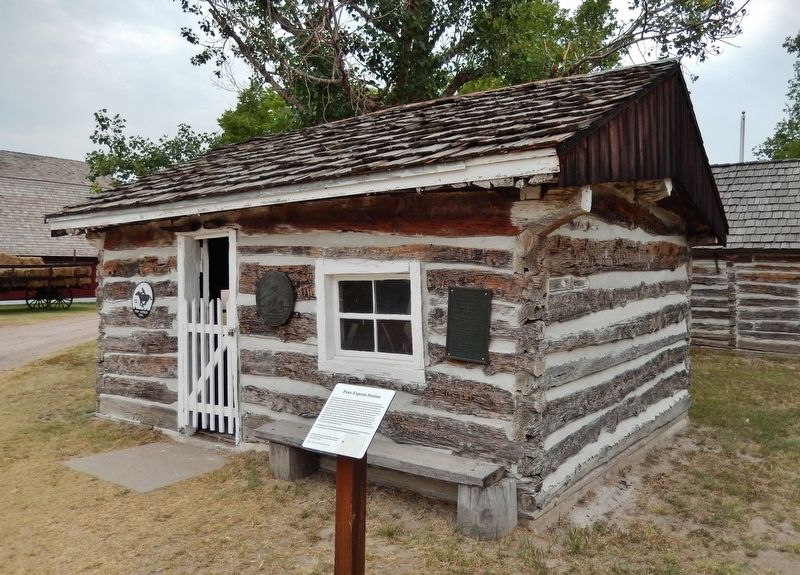
This cabin built in 1867
and restored by Sioux Lookout Chapter D. A. R. 1924 in honor of the early pioneers of North Platte, Nebraska — — Map (db m242273) HM
A general store was the Wal-Mart of the 19th Century. It supplied the local community with all the items needed for everyday living. The merchandise reflected the needs of the population, whether it was a farming community or ranching community. The . . . — — Map (db m191767) HM
This log, two-story, cedar log structure was built in 1868 or 1869 by Mr. E.E. Ericsson. Each log is shaped and interlocked with the next with a minimal use of square nails. Mr. Ericsson was born in Varmland, Sweden on July 1st, 1835. He arrived . . . — — Map (db m191768) HM
You are standing in front of a typical scene found in most farmyards in Lincoln County. A windmill and cistern were vital to the survival of both humans and livestock, especially during the hot, dry Nebraska summers. The windmill allowed farmers and . . . — — Map (db m191774) HM
This barber shop was first listed for taxes in 1900 according to Court House records. The building, mirrors on the back wall, rack on west side, and the smaller barber pole were those of Dick Neve. Both barber chairs, hat rack, the shelf and . . . — — Map (db m191779) HM
This flat iron cage was used by the city of Maxwell, Nebraska as their local jail. Purchased in 1917 for $144.50, it was placed in the fire station. The iron framework inside was for use as a bed with a thin mattress on it. — — Map (db m191784) HM
The Fredericksen House was built on the site of 315 West Third Street in North Platte, Nebraska in about 1899. It was constructed precisely to the specifications that Fred Fredrickson designed himself. The house cost $2,300 and was paid in six . . . — — Map (db m191811) HM
This giant plow was used to dig drainage ditches along the Nemaha River in eastern Nebraska, the Platte River here in Lincoln County, the Medicine Creek south of here in Frontier County, near Big Springs, Nebraska, and in Colorado and Wyoming. . . . — — Map (db m191851) HM
This "crab" is a reproduction of the original used with the ditch plow. It was pulled into the ground as a wedge and a cable was run through a pulley in its center and back to the plow. Using block & tackle and the crab as an anchor, the oxen pulled . . . — — Map (db m191884) HM
This capstan was used when marshy ground made direct pulling with oxen impossible. A cable was unwound from the spool in the center of the capstan and attached to the ditch plow. Teams of oxen or draft horses were hitched to the wooden arm of the . . . — — Map (db m191897) HM
These reproduction yokes would sit over the necks of two oxen each. Oxbows, small bent wood rods were placed under the oxen's necks and through the holes in the yokes and secured with pins. This allowed the yoke to secure itself against the oxen's . . . — — Map (db m191894) HM
Blacksmithing is the working of iron. It dates back to around 1400 B.C. and by 1000 B.C. the use of iron had spread to the point that it surpassed copper and gave its name to the Iron Age. Blacksmithing reached its golden age during the High . . . — — Map (db m191898) HM
This schoolhouse was located four miles north and four miles west of Hershey, Nebraska and was called "Lower Birdwood". On January 22, 1892, the representatives from both the State of Nebraska and Lincoln County signed an agreement claiming this as . . . — — Map (db m191860) HM
This is the boyhood home of William "Bill" M. Jeffers, president of the Union Pacific Railroad from 1937-1946. Remarkably he began his career as a janitor & call boy. As president, he prepared the railroad for the coming war and was appointed by . . . — — Map (db m191890) HM
100-CA-7 class cabooses were built in Union Pacific shops in Omaha, Nebraska in 1959, numbered 25400 thru 25499. This caboose was updated in 1975 with federally approved toilets, axle-driven alternators, and other items necessary for system-wide . . . — — Map (db m191899) HM
After the completion of the Transcontinental Railroad in 1869, settlers began to establish farms and ranches all around the railroad line and they needed access to the railroad to ship their crops and cattle to market and travel to neighboring . . . — — Map (db m191900) HM
This shield is from the North Platte, NE. Union Pacific Depot 3-20-1918 to 11-1-1973 Home of WWII Canteen 12-25-1941 to 4-1-1946 — — Map (db m191939) HM
The Pawnee were one of the most important Native American tribes of the Plains area. By the late eighteenth and early nineteenth centuries they were living in circular earthlodges in large villages, sometimes including more than a thousand people. . . . — — Map (db m191940) HM