31 entries match your criteria.
Kansas City - Native Sons and Daughters of Greater Kansas City Historical Markers
More than 100 historic markers that signify events and locations highlighting the political, military, social, and economic history of greater Kansas City.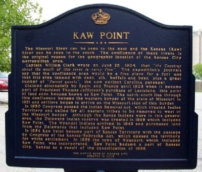
By William Fischer, Jr., August 30, 2011
Kaw Point Marker (Side B)
| 1 ► Kansas, Wyandotte County, Kansas City, Fairfax — Lewis and Clark at Kaw Point / Kaw Point — June 26-29, 1804 — |
| 2 ► Kansas, Wyandotte County, Kansas City, Muncie — Grinter House — |
| 3 ► Missouri, Clay County, Kansas City, Antioch Acres — Antioch Church — |
| On NE Antioch Road (Missouri Route 1) at NE 48th Street, on the right when traveling north on NE Antioch Road. | |||
| 4 ► Missouri, Clay County, Liberty — "The Old Graveyard" "Mt. Memorial Cemetery" — |
| On Miller Avenue at William Jewell College Drive, on the right when traveling west on Miller Avenue. | |||
| 5 ► Missouri, Jackson County, Kansas City, 18th And Vine — American Jazz Museum — |
| Near Vine Street north of 18th Street, on the right when traveling north. | |||
| 6 ► Missouri, Jackson County, Kansas City, 18th And Vine — Negro Leagues Baseball Museum — |
| On Vine Street north of 18th Street, on the right when traveling north. | |||
| 7 ► Missouri, Jackson County, Kansas City, Central Hyde Park — The First Golf Course in Kansas City — |
| On Gillham Road at 36th Street, on the left when traveling south on Gillham Road. | |||
| 8 ► Missouri, Jackson County, Kansas City, Countryside — James G. Ashley, Jr. and Pamela C. Ashley — |
| On Brookside Boulevard at 55th Street, on the right when traveling north on Brookside Boulevard. | |||
| 9 ► Missouri, Jackson County, Kansas City, Downtown Kansas City — Convention Center — |
| On 13th Street, 0.1 miles east of Central Avenue, on the right when traveling west. | |||
| 10 ► Missouri, Jackson County, Kansas City, Downtown Kansas City — George Caleb Bingham — Born March 20, 1811 - Died July 7, 1879 — |
| 11 ► Missouri, Jackson County, Kansas City, Downtown Kansas City — Kansas City Metropolitan Crime Commission — |
| On W 14th Street, on the right when traveling north. | |||
| 12 ► Missouri, Jackson County, Kansas City, Downtown Kansas City — Kansas City Stock Yards — |
| On Arena Drive at American Royal Drive, on the right when traveling west on Arena Drive. | |||
| 13 ► Missouri, Jackson County, Kansas City, Downtown Kansas City — Richard Thomas Coles / R.T. Coles Vocational and Junior High School — |
| On East 19th Street at Tracy Avenue, on the right when traveling west on East 19th Street. | |||
| 14 ► Missouri, Jackson County, Kansas City, Downtown Kansas City — The American Royal — (original location) — |
| On American Royal Court, on the right when traveling east. | |||
| 15 ► Missouri, Jackson County, Kansas City, Downtown Kansas City — The Cemetery — |
| On Cemetery Road at Warwick Trafficway, on the left when traveling east on Cemetery Road. | |||
| 16 ► Missouri, Jackson County, Kansas City, Downtown Kansas City — Union Prison Collapse — |
| On Grand Boulevard at Truman Road North Drive, on the right when traveling north on Grand Boulevard. | |||
| 17 ► Missouri, Jackson County, Kansas City, Downtown Kansas City — Union Station Kansas City — |
| On West Pershing Road at Main Street, on the right when traveling west on West Pershing Road. | |||
| 18 ► Missouri, Jackson County, Kansas City, East Side — The Truman Sports Complex — |
| On Chiefs Way at Red Coat Lane, on the right on Chiefs Way. | |||
| 19 ► Missouri, Jackson County, Kansas City, Library District — Camp Union — |
| On Tenth Street, 0.1 miles west of Central Avenue, on the right when traveling east. | |||
| 20 ► Missouri, Jackson County, Kansas City, Library District — The Savoy Hotel and Grill — |
| On Central Street at 9th Street, on the right when traveling north on Central Street. | |||
| 21 ► Missouri, Jackson County, Kansas City, Old Westport — Historic Harris-Kearney House — |
| On Baltimore Avenue at West 40th Street, on the right when traveling south on Baltimore Avenue. | |||
| 22 ► Missouri, Jackson County, Kansas City, Old Westport — The Albert G. Boone Store — |
| On Pennsylvania Avenue at Westport Road on Pennsylvania Avenue. | |||
| 23 ► Missouri, Jackson County, Kansas City, River Market — City Market — 150th Anniversary — 1857 - 2007 — |
| On 3rd Street at Main Street, on the right when traveling east on 3rd Street. | |||
| 24 ► Missouri, Jackson County, Kansas City, Sunset Hill — 3 — Battle of Westport — Union Flanking Movement — |
| On Sunset Drive at 51st Street, in the median on Sunset Drive. | |||
| 25 ► Missouri, Jackson County, Kansas City, Sunset Hill — First Home of the Kansas City Country Club — |
| 26 ► Missouri, Jackson County, Kansas City, Swope Park — Kansas City's First Public Golf Course — |
| On Swope Parkway, 0.2 miles east of Meyer Boulevard. | |||
| 27 ► Missouri, Jackson County, Kansas City, Swope Parkway - Elmwood — 16 — Byram's Ford Battlefield — |
| On Manchester Trafficway, 0.2 miles north of East 63rd Street, on the right when traveling east. | |||
| 28 ► Missouri, Jackson County, Kansas City, Valentine — Historic Flaven/Browne Building Complex — |
| On Pennsylvania Ave. at 33rd Steet, on the left when traveling west on Pennsylvania Ave.. | |||
| 29 ► Missouri, Jackson County, Sibley — Fort Osage — |
| On Osage Street, on the right when traveling north. | |||
| 30 ► Missouri, Jackson County, Sibley — Restoration of Fort Osage — |
| Near Osage Street just north of 3rd Street, on the right when traveling north. | |||
| 31 ► Missouri, Platte County, Platte City — Platte City — William McClung Paxton — |
| On Main Street at 1st Street, on the right when traveling west on Main Street. | |||