On East Main Street at South Main Street (Business U.S. 51), on the right when traveling east on East Main Street.
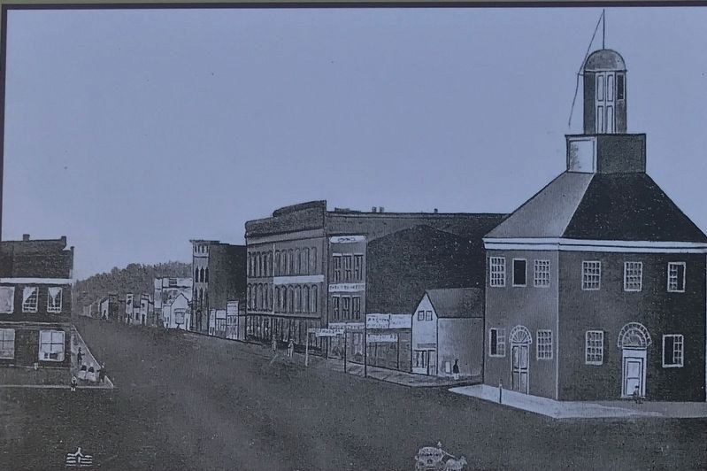
The second courthouse was an imposing structure far that time. Located on the southeast corner of Main and Main, it stood over forty feet tall, was made entirely of brick, and had a cupola for the courthouse bell. When not in use as a courthouse, . . . — — Map (db m183838) HM
On West Williams Street at North Edwards Street on West Williams Street.
Richard J. Oglesby was born in Kentucky, journeyed to Decatur as a young orphan, and later became one of Decatur's most prominentand best-loved citizens. Oglesby made a small fortune in the California Gold Rush and fought in both the . . . — — Map (db m56877) HM
On North Merchant Street at East Main Street, on the right when traveling south on North Merchant Street.
In June 1830 farm hand Abraham Lincoln was working on the farm of his relation, William Hanks, just a few blocks from the main square in Decatur. Suddenly, he heard a disturbance coming from the square. Hopping the fence and heading to the . . . — — Map (db m183839) HM
During his presidency, Abraham Lincoln had promised to care for the men in the armed services-and for their widows and orphans. Lincoln was unable, however, to keep that promise. In response, the Grand Army of the Republic or G.A.R. . . . — — Map (db m56908) HM
On North Franklin Street at E. Prairie Ave. on North Franklin Street.
In December 1849, an unusual event occurred for the lawyers who traveled on the Eighth Circuit. Mrs. Jane Martin Johns had recently moved to Decatur with her husband. She had set up temporary residence in the Macon House when her piano . . . — — Map (db m56906) HM
On South Park Street at North Water Street on South Park Street.
The City of Decatur was chosen as the site for the 1860 Republican State Convention with Abraham Lincoln as the most prominent Republican present. As the convention delegates were beginning to take their first, formal balloting, Richard . . . — — Map (db m56912) HM
On North Water Street at East Main Street, on the right when traveling south on North Water Street.
The second day of the 1860 Illinois State Republican Convention, May 10th, arrived bright and sunny. While many of the events that would mark this Convention occurred on May 9th, including the “Railsplitter” demonstration, May 10th would . . . — — Map (db m183841) HM
On Market Street south of West Broadway, on the left when traveling north.
Rich in heritage and haunted by history, many threads of our nation's past can be discovered here in Alton.
Located at the confluence of the Mississippi, Illinois, and Missouri rivers, Alton is one of America's great river towns. It was . . . — — Map (db m133286) HM
Near East 5th Street at Monument Avenue, on the left when traveling east.
Considered by many to be the first casualty of the Civil War, abolitionist editor and Presbyterian minister Rev. Elijah P. Lovejoy was killed defending the freedom of the press.
Editor of the St. Louis Observer, Lovejoy wrote . . . — — Map (db m133295) HM
On Market Street south of West Broadway, on the left when traveling north.
The two life-like statues represent a monumental event in our nation's history—the Lincoln-Douglas debates.
For a decade, the Illinois U.S. Senate seat was held by Stephen A. Douglas, one of the most famous politicians of his time. . . . — — Map (db m133288) HM
On Henry Street at East 12th Street, on the right when traveling north on Henry Street.
The stately house down the block once housed the co-author of the 13th Amendment, which abolished slavery in the United States.
In giving freedom to the slave, we assure freedom to the free—honorable alike in what we give and what we . . . — — Map (db m133291) HM
On Alby Street at East Broadway, on the right when traveling south on Alby Street.
Lincoln made frequent legal and political trips to Alton putting him in the heart of Alton history.
For nearly twenty-five years before becoming president, Lincoln was a general practice attorney, representing clients in a variety of . . . — — Map (db m133290) HM
On State Street north of West Broadway (Illinois Route 100), on the right when traveling north.
The Franklin House hotel served as Lincoln's debate headquarters and reception area during the final debate.
In 1858, great debates were staged for the public with carnival-like appeal. People came from across Illinois and nearby states to . . . — — Map (db m164649) HM
On South Side Square (at milepost 0), on the left when traveling east.
Lincoln Photograph. Abraham Lincoln visited the city of Macomb twice in 1858. His first visit lasted from August 25th to August 26th, and it was unexpected. The Randolph House was the place that attracted Abraham Lincoln to Macomb. Lincoln . . . — — Map (db m59987) HM
"My line of defense is going to be that your tongue is no slanderer...that the people generally know you to be, impulsive and say things that you do not mean, and they do not consider what you say as slander," was Lincoln's defense of . . . — — Map (db m57379) HM
"I am now free to make an engagement for the road; and if you think fit you may 'count me in,'" wrote Lincoln to Illinois Central Railroad attorney Mason Brayman in October 1853. In 1851, the Illinois Central Railroad charter had . . . — — Map (db m57561) HM
On North Main Street, on the right when traveling north.
“A rustic on his first visit to the circus” is how John W. Baddeley, an English immigrant farmer described Abraham Lincoln on his first visit to the McLean County Courthouse as a young attorney in the summer of 1837. Lincoln was wearing . . . — — Map (db m12362) HM
On East Jefferson Street at North McLean Street on East Jefferson Street.
"His love of wealth was very weak....he said he had no capacity whatever for speculation and never attempted it." So said attorney friend Joseph Gillespie who once asked Lincoln how much land he owned and why he had never speculated in . . . — — Map (db m57559) HM
"...If they believe...Vandeventer pointed the gun at Swartz and advanced upon him, merely to intimidate Swartz.... so that he could get to kill the dog, and with no intention of him, or otherwise hurting him with the gun, that was no assault . . . — — Map (db m57454) HM
On Davis Avenue at Monroe Drive, on the right when traveling north on Davis Avenue.
The frame house (left) that once stood on the site of this Victorian mansion was the home of Abraham Lincoln’s trusted friend, legal associate, and political manager, David Davis (1815-1886). The two-story structure closely resembled Lincoln’s . . . — — Map (db m12263) HM
On S. East Street at Front Street on S. East Street.
"I look upon that enactment not as a 'law,' but as 'violence' from the beginning. It was conceived in violence, passed in violence, is maintained in violence, and is being executed in violence. I say it was 'conceived' in violence, because . . . — — Map (db m57456) HM
On West Front Street west of North Main Street, on the right when traveling west.
"Why if that one is named Democrat, I will name this one Whig," Lincoln said to John Ewing the proprietor. Such was Lincoln's affection for the family of John Ewing, who ran the hotel in the 1840's. John had nicknamed one of his sons . . . — — Map (db m57550) HM
On Washington Street at Main Street, on the left when traveling east on Washington Street.
"Herewith is a little sketch...there is not much of it...I suppose, that there is not much of me." Lincoln thus fulfilled Jesse Fell's 1858 request for an autobiography. Catching Lincoln as he emerged from the courthouse, Fell invited . . . — — Map (db m57553) HM
On West Monroe Street at Nortth Center Street on West Monroe Street.
"While I am writing speakers are addressing the people from the portico of the Pike House." Thus wrote the correspondent of the Chicago Democrat Press on the morning of May 29, 1856. The Anti-Nebraska Convention was scheduled to . . . — — Map (db m57556) HM
On North Main Street just south of W. Locust Street.
"I am in a little trouble here---I am trying to get a decree for our 'Billy the Barber' for the conveyance of certain town lots sold to him by Allin Gridley and Prickett...." Lincoln explained that "Billy will blame me, if I do not . . . — — Map (db m57558) HM
On South University Street north of Dry Grove Street, on the right when traveling north.
Thanks to the foresight and generosity of Abraham Lincoln's McLean County friends, Jesse W. Fell, David Davis, and others, the Illinois State Board of Education located the first state-supported university near the junction of the Illinois . . . — — Map (db m183699) HM
On 6th Street at East Jackson Street on 6th Street.
After moving to Springfield, Abraham Lincoln would visit the Petersburg area and stay overnight at the Menard House. When Lincoln was on the Judicial Circuit, he traveled from court to court, often sleeping at the local hotel or tavern. . . . — — Map (db m57373) HM
On South 7th Street at West Jackson Street on South 7th Street.
Abraham Lincoln surveyed the town of Petersburg certifying his plat on February 17,1836, five days after his 27th birthday. At the time he was still living in New Salem. He later surveyed several additions to the Petersburg plat. Though . . . — — Map (db m57371) HM
On West Jackson Street at 7th Street on West Jackson Street.
Abraham Lincoln laid out the original sixty blocks of Petersburg, Illinois between November 1835 and February 1836. In 1832, Peter Lukins and George Warburton had laid out a few lots for a new town. Lukins and Warburton played a card . . . — — Map (db m57348) HM
Abraham Lincoln and incumbent Stephen A. Douglas spent ten weeks in 1858, contesting for the U.S. Senate. During the grueling campaign, Lincoln made sixty-three speeches across the state; Douglas made 130. Both men spoke separately in . . . — — Map (db m57637) HM
Since 1856, Beecher Hall has been the headquarters of two of Illinois College men's societies. Sigma Pi Society and Phi Alpha Society. Both societies elected Abraham Lincoln into honorary membership in their fraternal-literary . . . — — Map (db m57657) HM
Abraham Lincoln won his elected office, a seat in the Illinois House of Representatives in 1834. That same year Joseph Duncan of Jacksonville was elected Governor of Illinois. Before you stands the home of Joseph Duncan, which became the . . . — — Map (db m241999) HM
On East State Street just east of Spaulding Place.
Abraham Lincoln met Benjamin H. Grierson when the two campaigned for the Republican Party. Grierson, a merchant, music teacher, and musician, even wrote a song for Lincoln's presidential campaign in 1860, with the chorus: "So clear . . . — — Map (db m57635) HM
On E. State Street just east of N. East Street, on the right when traveling east.
Abraham Lincoln met the Reverend James F. Jaquess when Lincoln was a lawyer on the Eighth Judicial Circuit and Jaquess rode the Petersburg Circuit for the Methodist Church. They became better acquainted in Jacksonville when Jaquess was . . . — — Map (db m57630) HM
Pictured in the crowd listening to Abraham Lincoln's speech is Joseph O. King, a prominent merchant who later became mayor of Jacksonville. He helped found a political group that agitated for the exclusion of slavery from the free . . . — — Map (db m57653) HM
On West State Street just west of Westminster Street, on the left when traveling west.
Abraham Lincoln was often accused by his detractors---and even by some of his friends---of not being a Christian. Just before becoming President, Lincoln shared the following with his friend Dr. Newton Bateman: "I know there is a God, . . . — — Map (db m57648) HM
On E. State Street, on the left when traveling east.
Richard Yates moved from Kentucky to Jacksonville in 1831. Four years later he became the first graduate of Illinois College. Abraham Lincoln and Yates admired Henry Clay and actively supported the Whig Party. Both strongly opposed . . . — — Map (db m57633) HM
On E. State Street at Hardin Avenue on E. State Street.
A native of Kentucky, John J. Hardin moved to Jacksonville in 1831 when he was twenty-one. Like other young men of their generation. Hardin and Abraham Lincoln served in the Black Hawk War. Both men were lawyers and Whig politicians who . . . — — Map (db m57634) HM
On East Wilson Street east of North Macon Street, on the left when traveling east.
Edgar Camp came to Bement in 1855 along with two brothers. As one of the early settlers, he assisted in building the first houses. The Camp boys were joined by another brother in 1858.
When Civil War broke out, Edgar, James and William . . . — — Map (db m23897) HM
On East Wilson Street east of North Macon Street, on the left when traveling east.
Lincoln wrote Douglas on July 24, 1858, challenging him “to divide time and address the same audiences” during the campaign. The Senator suggested seven locations, adding, “I will confer with you at the earliest . . . — — Map (db m23858) HM
On East Wilson Street east of North Macon Street, on the left when traveling east.
A pocket watch is meant to be used with a chain. Three styles were popular: T-bar, which slips through a vest buttonhole; spring ring, which attaches to a belt loop; and fob. Lincoln’s pocket watch shown here has a shorter style chain, featuring . . . — — Map (db m23889) HM
On East Main Street east of South State Street, on the right when traveling east.
The Tenbrook Hotel, the building shown on the right-hand side of the photo (which was taken at the end of the Civil War), was the site where Lincoln and other members of the bar lodged when traversing the Eighth Judicial Circuit. Lincoln . . . — — Map (db m23855) HM
On North Independence Street north of East Livingston Street, on the left when traveling north.
Lincoln’s journeys to Monticello were sometimes difficult because of the weather and his lack of popularity on some issues.
Lincoln, Judge David Davis, and other members of the Bar were trying to reach Monticello in the spring of 1852, having . . . — — Map (db m23813) HM
On Iron Horse Place east of Iron Horse Lane, on the right when traveling east.
The I.C.R.R. Co. Steam locomotive was popular in the mid 1850's, when Lincoln worked for the Illinois Central. It was named “American Standard,” and latter ran from Decatur to Champaign. Locomotives were originally wood burning, and the railroad . . . — — Map (db m23808) HM
On Fayette Street, on the right when traveling east.
Lincoln visited here. Lincoln’s 1858 Senatorial campaign visit to Pittsfield prompted a test firing of the cannon which was a popular campaign practice of the time. Charles Lame was seriously injured during the test firing. Lincoln walked down to . . . — — Map (db m128777) HM
On East Washington Street (Illinois Route 106) west of Lashmett Lane, on the right when traveling east.
Built 1845-1846, partially destroyed by fire and rebuilt in 1896. Lincoln stayed here during his 1858 Senatorial campaign visit. Ross served as an aide to Gen. Atkinson and was responsible for Lincoln's appointment to company captaincy during the . . . — — Map (db m128771) HM
On Washington Street (U.S. 54) at Madison Street, on the right when traveling west on Washington Street.
Pike County, Illinois was organized January 31, 1821,
named for Zebulon Pike, early explorer of the Louisiana Purchase and general in the War of 1812. The first settlement in 1820 was founded by Ebenezer Franklin, followed by Daniel . . . — — Map (db m68919) HM
On West Washington Street (U.S. 54) at Madison Street, on the right when traveling west on West Washington Street.
Abraham Lincoln was a frequent visitor to Pike County.
He left his judicial circuit and crossed the Illinois River to practice law with many of Pike County's leading attorneys, forming close associations with prominent Whig and . . . — — Map (db m68918) HM
On North Monroe Street north of East Washington Street (U.S. 54), on the right when traveling north.
John Nicolay was only 16 years old when he gained employment as a printer’s devil at this site; he would eventually become the sole proprietor of the Free Press Newspaper. When old friends Tom Shastid and Abraham Lincoln met one day in Pittsfield, . . . — — Map (db m128772) HM
On Washington Street, on the right when traveling west.
Abraham Lincoln formed some very close friendships with several citizens of Pittsfield. Among the most prominent ones were Milton Hay, John Milton Hay, and John George Nicolay. Milton Hay was born in 1817, and he moved to Pittsfield in 1840. He was . . . — — Map (db m128776) HM
On East Washington Street (Illinois Route 106) east of North Illinois Street, on the right when traveling west.
When John George Nicolay was sixteen years old, a friend showed him an ad in The Pike County Free Press newspaper dated May 11, 1848. It advertised for "An intelligent boy, 14 to 17 years of age, who can read and write, to learn the Printing . . . — — Map (db m128774) HM
On East Jefferson Street at North Illinois Street, on the right when traveling west on East Jefferson Street.
John G. Shastid moved his family to Pittsfield in 1836 from New Salem, where he had been a neighbor to Abraham Lincoln.
Pittsfield was the county seat, yet there were only six houses here at the time. John bought one of them. Finding the . . . — — Map (db m128775) HM
On East Monroe Street at South 7th Street on East Monroe Street.
Cultural differences made it hard for citizens to agree on animal control policies. Well into the 1850's hogs freely roamed the streets, contesting the walkways with pedestrians, rooting up sidewalk planks, and creating smelly "how . . . — — Map (db m57077) HM
On East Washington Street, on the right when traveling east.
In 1860 Emanuel Brunswick opened a billiard hall in the second floor of the building just east of the Chenery House here on Washington Street. It contained elegant Brunswick tables and was touted as the largest and best hall in Illinois . . . — — Map (db m57057) HM
Shoppers at Clark M. Smith's All-Purpose Store on the South Side of the public square seldom paid cash. Money was scarce; credit accounts were common. Smith's in-laws---the Lincolns---had an account. After her husband lost the Senate race to . . . — — Map (db m48620) HM
(Left) Campaign poles sported flags and banners, such as this one from 1844 supporting Lincoln's hero, Henry clay. Lashed to Lincoln's 120-foot presidential Ash Pole in 1860 was a broom--- signifying Lincoln's intent to sweep corrupt Democrats . . . — — Map (db m48902) HM
On S. 6th Street at E, Adams Street on S. 6th Street.
When it opened in 1858, Cook's Hall became the largest of Springfield's public halls. Its gas-lighted auditorium and gallery were the grandest in the region. A wealthy soap and candle manufacturer, John Cook, built the hall following a . . . — — Map (db m48557) HM
On S. 6th Street at E. Adams Street on S. 6th Street.
Apothecaries in the mid-19th century carried a surprising variety of drugs and remedies—potassium iodide for rheumatism and syphilis, sulphate of quinine for tooth powder, opium elixir for toothache, and . . . — — Map (db m48560) HM
The Gregarious General Isaac B. Curran was a prominent citizen in Lincoln's Springfield. His store here on the south side of the square was a popular gathering place for Lincoln's political opponents. Curran arrived as a young silversmith from . . . — — Map (db m180409) HM
William Florville was Lincoln's barber for twenty-four years. Florville, or de Fleurville ("Billy the Barber" to his white customers), was born in Haiti of French ancestry. He came to America at age fifteen and was a barber's apprentice in . . . — — Map (db m57193) HM
The Globe Tavern as it appeared in May 1865 at the time of Lincoln's funeral. the Lincolns lived here from November 1842 until the winter or early spring of 1844. At that time the tavern consisted of two buildings joined as a "T," with the older . . . — — Map (db m48903) HM
On E. Monroe Street at 10th Street on E. Monroe Street.
Throngs give big sendoff to Lincoln Monday morning February 11, 1861 dawned dismal and gray. A chilling drizzle soakedthe dirt roads of the capital. At 7:30 A.M., a carriage pulled up here in front of the depot, and President-elect . . . — — Map (db m48554) HM
November 1858 Register notices published on Election Day and the day after---documenting the end of the heated and hectic Lincoln-Douglas Senatorial contest.When the seat of government left Vandalia in 1839, the former capital;s . . . — — Map (db m48901) HM
On South 6th Street at E Adams Street, on the right when traveling south on South 6th Street.
1854 marked Lincoln's public return to politics following a five-year hiatus. That year Senator Stephen A. Douglas of Illinois pushed the "Kansas-Nebraska Act" through the U.S. Congress, overturning the 1820 Missouri Compromise line. Fearing . . . — — Map (db m48577) HM
There was a housing shortage in Springfield when 28 year old Abraham Lincoln---riding a borrowed horse---moved here from New Salem in April 1837. Builders couldn't keep up with the newly designated state capital. One of Lincoln's first stops . . . — — Map (db m48899) HM
On East Monroe Street at South 5th Street on East Monroe Street.
In November 1840 legislators convened in the cramped quarters of the Methodist Church while workers were completing the statehouse a block away. "The House of Representatives was crammed in a room barely large enough for the members . . . — — Map (db m57068) HM
On North MacArthur Blvd. just north of West Oak Ridge Street.
During four years as President, Abraham Lincoln spent much of his time among the troops. They were important because they were the people who would get the job done. He frequented the War Department's telegraph office to stay abreast of . . . — — Map (db m57340) HM
Lincoln's Springfield was vulnerable to fire, Crowded wood-frame buildings, open flames in stoves, fireplaces, candles, and primitive gas lighting ineffective alarms, muddy streets, and inadequate water supplies---all combined to make . . . — — Map (db m57167) HM
On South 7th Street just south of East Monroe Street.
Lincoln brought his buggy to Obed Lewis for servicing at his shop on the north side of Monroe Street between Sixth and Seventh Streets. When Lincoln first arrived in Springfield riding a borrowed horse he wondered at the "great deal of . . . — — Map (db m57164) HM
Americans had poor oral hygiene in Lincoln's era. Rotten teeth and foul breath were common (halitosis was not yet a social evil). Calomel frequently prescribed by doctors for fevers caused many people to have loose teeth. Dentistry was plagued . . . — — Map (db m48621) HM
On South 3rd Street south of East Jefferson Street (Illinois Route 97), on the left when traveling south.
The funeral train pulled into the Chicago & Alton Railroad station on Jefferson Street, at 8:40 A.M. on May 3, 1865.
Vast crowds had already poured into Springfield over the night of May 2, 1865, and more people were still arriving. Now, for . . . — — Map (db m160707) HM
Lincoln reportedly had a "very defective taste" in hats. At various times he was known to have worn fur caps, straw or palm hats, and broad, low-brimmed wool or felt hats. He is best known for the "plug" or stovepipe hats he wore as a lawyer . . . — — Map (db m48875) HM
On E. Capitol Ave. at 8th Street on E. Capitol Ave..
When Confederate Gen. Robert E. Lee surrendered to Union Gen. Ulysses S. Grant at Appomattox Court House, Virginia, on April 9, 1865,joyous citizens decorated Lincoln's horse, Old Bob, with flags and led him triumphantly through the streets of . . . — — Map (db m48553) HM
On East Lake Shore Drive south of North Pawnee Road, on the right when traveling south.
Abraham Lincoln spent the first twenty years of his life in the forests of Kentucky and Indiana. He migrated to Illinois and settled in the village of New Salem, located in the woodlands along the Sangamon River. Other early settlers also chose . . . — — Map (db m156786) HM
Lincoln and Herndon rented law offices at several locations over the years. Their last was a rear room on the second floor in a building that stood here. Leslie's Weekly published this drawing of the office interior during the 1860 presidential . . . — — Map (db m48896) HM
Twenty-eight-year-old Abraham Lincoln settled here in 1837. He was unmarried, unlearned, unrefined, with "no wealthy or popular relations to recommend me." On the day before his fifty-second birthday, Lincoln left here a profoundly changed man; . . . — — Map (db m48571) HM
On E. Capitol Avenue at 7th Street on E. Capitol Avenue.
These four Todd sisters each married a Springfield man and established households within a few blocks of each other, Elizabeth was the oldest and became Mary's surrogate mother." Frances lived closest to Mary (across the street where the Grace . . . — — Map (db m48550) HM
"Love is Eternal" were the words engraved in the plain gold band that Abraham Lincoln slipped on Mary's finger at their wedding in Springfield on November 4, 1842. The inscription reflected the ideal of "romantic love" that swept America in the . . . — — Map (db m48874) HM
On East Monroe Street at South 6th Street, on the right when traveling east on East Monroe Street.
During the 1860 election Illinois Republicans held conventions in temporary wood and canvas structures dubbed "Wigwams." "Wigwams" were reminiscent of the "Log Cabins" from the 1840 presidential campaign. They quickly became symbols of . . . — — Map (db m57073) HM
This is the how the east side of the public square looked from this vantage point (circa 1859), looking north along Sixth Street. The picture shows how buildings were refurbished following the great east-side fire of February 1858. but the . . . — — Map (db m48572) HM
On W. Adams Street at 5th Street on W. Adams Street.
West side of the public square This is the how west side of the public square looked from this vantage point (circa 1859), looking north along Fifth Street. In September 1859 "daguerrean" (photographer) Preston Butler advertised his four . . . — — Map (db m48741) HM
On Washington Street at 5th Street on Washington Street.
North side of the public square This is the how the north side of the public square looked from this vantage point (circa 1859), looking east along Washington Street. The rickety wood structures of "Chicken Row" that had been familiar to . . . — — Map (db m48742) HM
On East Adams Street at 5th Street on East Adams Street.
This is how the south side of the public square looked from this vantage point (circa 1859), looking east along Adams Street. Businesses at the time included (starting at right); J.W. Bunn Groceries; T.S. Little clothier, with a dental office and . . . — — Map (db m57063) HM
Before he moved to Springfield Abraham Lincoln came to the law office of John Todd Stuart to barrow law books. Henry E. Dummer---Stuart's partner at the time---recalled that the "uncouth looking" Lincoln said little and seemed timid. Yet . . . — — Map (db m57194) HM
Many people look at Mount Rushmore, carved in the Black Hills of South Dakota, as a monument to four Presidents, but land surveyors see it as "three surveyors and one other guy." Washington, Jefferson, and Lincoln all were land . . . — — Map (db m48744) HM
Abraham Lincoln accepted the Republican nomination for the U.S. Senate on June 16, 1858. To open his campaign, Lincoln delivered the famous House Divided speech from Springfield that evening. Upon hearing the speech, Senator Stephen A. . . . — — Map (db m57052) HM
On Southeast Old State Capitol Plaza at East Adams Street, on the left when traveling south on Southeast Old State Capitol Plaza.
Social galas and political functions were common at the American House. Stephen A.Douglas sometimes used the hotel as headquarters for the Democrats. (Below Left) A newspaper published Springfield's newest hotel under the direction of J. . . . — — Map (db m48569) HM
"The bathing rooms now kept by Rev. S. S. Ball in the rear of his Barber's Shop are in elegant trim for the accommodation of his Friends and the public," advertised Elder Samuel S. Ball.His shop was on the south side of the public square . . . — — Map (db m48619) HM
On S, 7th Street at E, Capitol Ave. on S, 7th Street.
Neighbor girl Josie Remann (left)was a favorite of Lincoln's. Once, on finding her in tears in front of her house, Lincoln ran all the way to the train station with her trunk on his shoulders because a carriage driver failed to come for it on . . . — — Map (db m48548) HM
The Springfield "urban" environment that shaped the childhood of the Lincoln boys was a far cry from the "backwoods wilderness" their father knew as a child. "Pay schools" and academies, railroad trains and fancy carriages, circuses and Sunday . . . — — Map (db m48575) HM
On South 7th Street at East Adams Street on South 7th Street.
Lyceums were community associations that sponsored lectures, debates, and discussions. Eastern Protestant missionaries and educators brought the concept to frontier Illinois. Promoters hoped their Lyceums would disseminate knowledge and . . . — — Map (db m57166) HM
On East Capitol Avenue west of South 6th Street, on the right when traveling west.
Virgil Hickox was one of many local people who disagreed politically with Abraham Lincoln. Raised in the traditions of Jeffersonian Democracy as a youth in New York, he settled in Springfield in 1834 and became a prosperous merchant, railroad . . . — — Map (db m156400) HM
On Lester Street at Elm Street, on the left when traveling west on Lester Street.
One of the first Republican caucuses in Sangamon County was held at Williamsville in 1856; they strengthened their numbers, held meetings, and expressed their vigorous opposition to slavery over the next three years. They referred to the foremost . . . — — Map (db m156863) HM
On South Congress Street (U.S. 24) at West Lafayette Street, on the right when traveling south on South Congress Street.
"Boys, this is a shaky platform, but the Republican party has a strong foundation," exclaiming a tottering Abraham Lincoln perched atop a pedestal in the yard of his Rushville host, William Ray, on the evening of October 19, 1858. A tremendous . . . — — Map (db m182091) HM
On South Congress Street (U.S. 24) south of West Madison Street, on the right when traveling south.
The frontier militia spirit is depicted in this 1940 calendar art rendering of Lincoln, the Soldier by artist Fletcher Ransom. When Chief Black Hawk in 1832 led Sac and Fox warriors on roads to recover their traditional grounds. Illinois . . . — — Map (db m182089) HM
On South Main Street south of East Main Street, on the right when traveling south.
Left Section In 1863, Ohio Governor David Tod believed that Lincoln needed a cavalry body-guard. Governor Tod requested one volunteer from each county in Ohio to serve on special duty. Guernsey County, in east-central Ohio supplied Ephraim . . . — — Map (db m30751) HM
On East Main Street (Illinois Route 16) east of Washington Street, on the right when traveling west.
Left Section
Anthony Thornton and Abraham Lincoln led fairly similar lives. Both were born in Kentucky, were tall, and were Whigs.
Both began practicing law in Illinois in 1836, even though Thornton was college-educated and read . . . — — Map (db m30755) HM
On East Main Street (Illinois Route 16) west of South Washington Street, on the right when traveling west.
Left Section
In the summer of 1856, Abraham Lincoln traveled across much of Illinois, giving speeches supporting the new Republican Party and its national and state candidates. On August 9, 1856, Lincoln arrived in Shelbyville to . . . — — Map (db m30801) HM
On East Main Street (Illinois Route 16) at Broadway Street, on the right when traveling east on East Main Street.
Abraham Lincoln visited Shelby County to argue law cases during his journeys around the Eighth Judicial Circuit.
Although Shelby County comprised a part of the circuit in the 1840's, Lincoln would forego visiting Shelbyville in favor of . . . — — Map (db m188365) HM
On East Main Street, on the right when traveling west.
Left Section
Taverns - - or Inns - - were the primary accommodation for the circuit traveler. Before arriving in Shelbyville, the judge and lawyers had a two-day journey from Paris, usually with an overnight stay in Charleston. Abraham . . . — — Map (db m30784) HM