Near Elmira Road, 1.6 kilometers south of Northside Road (Prince Edward Island Route 16), on the right when traveling south.
English:
The eastern terminus of the Confederation Trail is Elmira. It is a further nine kilometres by road to East Point, the eastern tip of land. The site is dominated by an octagonal white lighthouse built in 1867. Exceeding 19 . . . — — Map (db m141202) HM
Near Lighthouse Road, 2 kilometers east of East Point Road (Prince Edward Island Route 16), on the right when traveling east.
English:
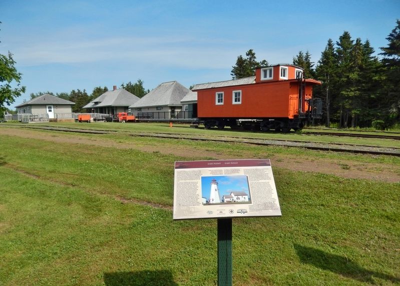
The original fog alarm building was added to the East Point Light Station in 1885 as a navigational aid. It was replaced in 1908 with a larger building at a cost of $8000.00, and remains one of the few intact fog alarm . . . — — Map (db m140620) HM
On Richmond Street close to West Street, on the right when traveling west.
English:
The Three Rivers - Montague, Brudenell, and Cardigan - wind through towns, villages and communities in Kings County, draining into Cardigan Bay, known to the Mi’Kmaq people as Samkook (sandy shore). One of the first French . . . — — Map (db m80296) HM
Established in 1720, Havre Saint
Pierre was once the largest
settlement in the colony of Isle Saint
Jean. On a summer day in the 1730s
this was a busy place. Here - a fleet
of tiny shallops, sails snapping as
they set out for the . . . — — Map (db m139397) HM
Near Black Brook Road, 0.3 kilometers north of Cape Bear Road (Prince Edward Island Route 18), on the right when traveling north.
John Whalen built the square tapered, 12.4 m Cape Bear Lighthouse in 1881. In 1947, it was moved back from eroding cliffs. Ewart A. Keeping was lightkeeper from 1926-1959. The attached dwelling was removed in 1960. The Marconi Wireless Station was . . . — — Map (db m198787) HM
On Station Lane just south of Cape Bear Road (Main Street) (Prince Edward Island Route 18), on the right when traveling south.
English:
Cape Bear is located on the Northumberland Strait side of the southeast corner of Prince Edward Island. The name survives in translation from the French period of Island history. The lighthouse was built in 1881, one of . . . — — Map (db m147964) HM
On Main Street (Prince Edward Island Route 18) just north of Westview Drive, on the right when traveling west.
English:
Murray Harbour began to achieve status as an important PEI port in the late 1700s. The earliest settlers in the area sustained themselves by fishing and farming but John Cambridge, the proprietor of Lot 64, was actively . . . — — Map (db m140239) HM
On Station Lane just south of Cape Bear Road (Main Street) (Prince Edward Island Route 18), on the right when traveling south.
English:
A well-protected fishing harbour lies a short distance down the South River from the end of the trail. Fishing boats are lined up on both sides of the waterway and storage sheds dominate the wharves. The quiet ripple-free . . . — — Map (db m147963) HM
On Woodside Shore Road north of Prince Edward Island Route 112, on the left when traveling north.
English: James Colledge Pope was born in Bedeque. A successful merchant and shipbuilder, he entered political life in 1857. Premier of the Island on two previous occasions (1865-7 and 1870-2), he again assumed that office in April, 1873, and . . . — — Map (db m137724) HM
Near Point Prim Road (Prince Edward Island Route 209) 11 kilometers west of Trans-Canada Highway (National Route 1).
English:
Despite its initial success, the Prince Edward Island Steam Navigation Company and its vessel, the St. George, ran into difficulties. Even with investments from New Brunswick and Nova Scotia, steamboats were . . . — — Map (db m140249) HM
Near Point Prim Road (Prince Edward Island Route 209) 11 kilometers west of Trans-Canada Highway (National Route 1).
English:
Prince Edward Island's contribution to Nova Scotia's lighthouses inspired the question: What about building a lighthouse here?
Petitions for lighthouses began to appear before government by the late 1830s. Concerned . . . — — Map (db m140246) HM
Near Point Prim Road (Prince Edward Island Route 209) 11 kilometers west of Trans-Canada Highway (National Route 1).
English:
At the same time that the Island was grappling with the issue of lighthouses, it found itself dealing with an issue of a different sort: Mail delivery.
Mail delivery was very important, representing the Island's . . . — — Map (db m140247) HM
Near Point Prim Road (Prince Edward Island Route 209) 11 kilometers west of Trans-Canada Highway (National Route 1).
English:
Late in the summer of 1864, two events descended upon the city of Charlottetown. One was a circus; the other, a political conference. Of the two, it was the circus that captured the attention of Islanders. But it was the . . . — — Map (db m140250) HM
Near Point Prim Road (Prince Edward Island Route 209) 11 kilometers west of Trans-Canada Highway (National Route 1).
English:
Imagine being aboard a ship on a dark, stormy night. The wind is howling fiercely, pushing large waves over the sides of your vessel. You are at the mercy of the elements. Picture a lack of navigational aids, creating a . . . — — Map (db m140245) HM
25 July, 1883. Thanks to a weekend of violent storms there is a heavy sea running. A few farmers watch with astonishment as a magnificent sailing vessel, driven by a mountain of canvas, slams onto the Cavendish sandbars. The air iš alive . . . — — Map (db m139391) HM
Sea Stories From the first peoples through modern times, the fishery has been vital
to the people living along this shore. As Lucy Maud Montgomery
remembered: Many of the farmers had a fishing house on the shore field
of their . . . — — Map (db m139429) HM
On Grafton Street at Water Street (Prince Edward Island Route 1), on the right when traveling east on Grafton Street.
English: "From the beginning, the river drew people to settle its banks and use its waters to reach the settlements..." The Hillsborough River, Elsitkuk as the Mi'kmaq would say, is the Island's largest river. It runs east . . . — — Map (db m149601) HM
On Water Street east of Queen Street, on the right when traveling east.
English: The Bonded Warehouse across the street was often at the centre of one of Charlottetown's most controversial issues: prohibition. In 1901 Prince Edward Island was the first Canadian province to make it illegal to possess, . . . — — Map (db m149598) HM
On Grafton Street at Water Street (Prince Edward Island Route 1), on the right when traveling east on Grafton Street.
English: Across Charlottetown Harbour on the west side was the home base for the Acadians in the early years of the 1700's. It was called Port-la-Joye and Fort Amherst by the English. The Mi'kmaq called it Skma qan which . . . — — Map (db m149600) HM
On Water Street close to Pownal Street, on the left when traveling west.
Born in Charlottetown, Davies studied law at the Inner Temple and was admitted to the bar in 1867. A member of the Legislative Assembly (1872-9) and Premier for the last three years of that period, he defended the rights of tenant farmers while . . . — — Map (db m80206) HM
Near Great George Street close to Water Street, on the left when traveling south.
English:
Between 1827 and 1856 the first complete hydrographic survey of the Gulf and River St. Lawrence was carried out by Captain Henry W. Bayfield and his assistants. From the time of Cartier, French and British navigators ad surveyed . . . — — Map (db m80198) HM
On Prince Street close to Water Street, on the left when traveling south.
English:
The Hillsborough River watershed, totaling over 350 square kilometres, is the largest river system in Prince Edward Island. As a river highway, it provides a direct link to our rich human heritage, from the Mi’Kmaq who depended on . . . — — Map (db m80187) HM
On Water Street (Prince Edward Island Route 1) at Grafton Street, on the left when traveling north on Water Street.
English: The Port of Charlottetown has a history of wooden shipbuilding, local ferry wharves and shipping connections with the world. Family connections with the Westcountry of England made it a prime destination. Shipbuilders, . . . — — Map (db m149906) HM
The three buildings on this site represent a "family” and all were once navigational aids. The lighthouse beacon is still maintained by the Canadian Coast Guard as part of the marine communication system used by ship traffic in the . . . — — Map (db m138223) HM