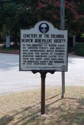
In this cemetery, 2½ blocks south, on Gadsden Street, are buried many distinguished Jewish citizens, including two mayors of Columbia: Mordecai Hendricks DeLeon (1791-1849) and Henry Lyons (1805-1858). The Benevolent Society was organized in . . . — — Map (db m28126) HM
This street, originally named Medium Street and part of the original 1786 Columbia Plan, bisected the area which was to be the campus of South Carolina College. The college, established in 1801 by an act of the General Assembly, later became the . . . — — Map (db m21848) HM
(West face)
Erected By popular subscription A Tribute To the worth and service of N.G. Gonzales, Born August 5, 1858, Died January 19,1903. —–— "Faithful unto death." Gonzales
(North face) A . . . — — Map (db m21926) HM
Dr. Matilda A. Evans (1872-1935), an African American physician, as well as a public health and civil rights advocate, lived here 1928-1935. A graduate of the Schofield School in Aiken and Oberlin College, Evans received her M.D. from the Woman’s . . . — — Map (db m134987) HM
Named for the Taylor family, this street is one of the original streets in the 1786 Columbia plan. Thomas Taylor was a member of the first and second Provincial Congresses, the General Assembly, and was a trustee of S.C. College. In 1791 he . . . — — Map (db m21812) HM
This hangar, built in 1929 by the Curtiss-Wright Flying Service, was the first building at Owens Field, a municipal airport then 3 mi. S of the city limits. Curtiss-Wright built and operated numerous airports across America for the next two . . . — — Map (db m55106) HM
This street is named for General John Barnwell, St. Helena's Parish. He was elected to the Provincial Congress of 1775-76 and to the 1776 General Assembly. A captain in the First Provincial Regiment, he was major, colonel and brigadier general in . . . — — Map (db m51236) HM
(side 1)
Authorized by the S.C. General Assembly in 1965 and constructed 1967-1969, this building was dedicated as the South Carolina State Library on Feb. 18, 1970. It was designed by architects Geiger, Califf, and Player. Funding for . . . — — Map (db m223590) HM
Good Samaritan-Waverly Hospital, created in 1938 by the merger of two older hospitals, served the black community in Columbia for 35 years. It merged Good Samaritan Hospital, founded in 1910 by Dr. William S. Rhodes and his wife . . . — — Map (db m219130) HM
This house, built after 1900, was originally a two-story frame residence with a projecting bay and wraparound porch; a fire in 1989 destroyed the second story. Barrett Visanska (1849-1932), a jeweler, bought the house in 1913. Visanska, a native . . . — — Map (db m119157) HM
This one-room primary school, built about 1925, stood about 1 mi. E, at the intersection of Killian and Longtown Roads, until 2001. There was a school at Killian (also called Killian’s) as early as 1905. From 1913 to 1948 Killian School had two . . . — — Map (db m43627) HM
Anthony Hampton
Feb. 3, 1715 - July 1776
with
wife, son Preston, and grandson
massacreed by Cherokee Indians,
July 1776
Tyger River, Spartanburg
District, S. C.
Maj. Gen. Wade Hampton
1752 - 1835
Col. Wade Hampton,
1791 - 1858 . . . — — Map (db m10400) HM
[Front]:
The Town of Irmo was established in a small farming community when the Columbia, Newberry and Laurens Railroad constructed its line here in february of 1890. The town was incorporated by the SC General Assembly in December of . . . — — Map (db m21525) HM
The first school built here c.1890 was a two-room frame building that was replaced c.1918 by a two-story brick school. In 1921 another classroom building and an auditorium were added. The federal Works Progress Administration helped fund several . . . — — Map (db m138341) HM
This street is thought to take its name from the cotton blossom. Cotton became an important commercial crop in South Carolina after the cotton gin was patented by Eli Whitney in 1794. A variety of cotton, known as Sea Island cotton and grown along . . . — — Map (db m21777) HM
One of the original streets in the 1786 Columbia plan. Lady Street is thought to have been named for Martha Custis Washington, the new nation's first lady whom South Carolina wished to honor. Lady Washington presided over the President's home, . . . — — Map (db m21791) HM
A Virginia native who came to South Carolina ca. 1765, General Thomas Sumter was a leader in civil as well as military affairs. He served in the First and Second Provincial Congresses, in the S.C. General Assembly, as U.S. Congressman and U.S. . . . — — Map (db m7651) HM
The Woman’s Club of Columbia was founded in 1925 as a civic and social club for local women. In 1941, their first permanent clubhouse was built here on a lot of land provided by Columbia City Council. Members held meetings there as well as . . . — — Map (db m223486) HM
In 1872 Samuel Barber (d. 1891) and his wife Harriet (d. 1899), both former slaves, bought 42½ acres here from the S.C. Land Commission, established in 1869 to give freedmen and freedwomen the opportunity to own land. Barber, a well-digger as a . . . — — Map (db m38083) HM
South Carolina Remembers the 2752 victims and 416 First Responders from New York City that gave their lives on September 11, 2001 — — Map (db m50333) HM
From 1963 to 1979, this was the office of Dr. Cyril O. Spann (1916-1979), one of the first fully trained African American surgeons in S.C. Born in Chester, Spann fought in World War II and attended nearby Benedict College. After graduating from . . . — — Map (db m219126) HM
This house was built ca. 1855 for George P. Hoffman (1829-1902), a native of N.C. Hoffman ran a nearby sawmill and became the first postmaster of Doko (as Blythewood was first known) in 1856. This area was part of Fairfield County until 1913, . . . — — Map (db m42607) HM
This marker honors Colonel Thomas Taylor, Patriot of the American Revolution. It is erected during this bicentennial year of 1976 to commemorate his contribution to the educational, cultural, civic, and religious life of the people of Richland . . . — — Map (db m51187) HM
The Robert Mills
Historic House and Park
established 1967 by the
Historic Columbia Foundation
and the
Richland County Historic
Preservation Commission
through the generosity of its
Patrons and Founders . . . — — Map (db m292556) HM
First church built 1824; present church 1906. In the churchyard is buried John R. Niernsee (1823-85), Major C. S. A.; architect of the State House. Ursuline convent located SE corner Main and Blanding streets 1858-65; Valle Crucis 1865-87; . . . — — Map (db m32749) HM
This was the adult home of pioneering S.C. civil rights attorney Harold R. Boulware (1913-1982). Born and raised in Irmo, Boulware attended Harbison Institute where his parents were both teachers. In 1938 he obtained his law degree from Howard . . . — — Map (db m300167) HM
This river took its name from the Congaree Indians, a Siouan tribe which occupied the valley until the Yamassee War in 1715. The first wooden bridge here was completed in 1827. It was burned to delay the advance of Sherman's Army in 1865, rebuilt . . . — — Map (db m7366) HM
The first bridge at Gervais Street was a covered wooden structure built in 1827 by the Columbia Bridge Company. It remained until 1865 when Confederate soldiers burned it and other bridges to delay the
advance of Sherman's troops. Rebuilt in . . . — — Map (db m7365) HM
(Upper Medallion)
National Register of Historic Places
First Presbyterian Church
South Carolina
Department of Archives
and History
(Lower Medallion)
American Revolution Bicentennial
* Richland County Committee * . . . — — Map (db m32312) HM
This fountain in honor of
The Carolina Patriots
Who Fought In
The American Revolution
Given by The American Revolution Bicentennial
Richland County Committee
The University South Carolina Society
The Lucy . . . — — Map (db m50961) HM
(Upper Medallion)
American Revolution Bicentennial
* Richland County Committee *
Landmark 78
(Lower Medallion)
National Register of Historic Places
St. Peter's Roman Catholic Church
South Carolina . . . — — Map (db m32280) HM
The Sustainers Garden is dedicated to the memory of four pillars of Columbia's philanthropic community, each of whom contributed significantly to the mission of Historic Columbia and other local non-profits. By dedicating their resources, of ten . . . — — Map (db m292375) HM
After Red Shirt campaign of 1876 Wade Hampton was inaugurated governor of South Carolina at Carolina Hall which stood in center of this square. During the dual government that followed, the Democratic House of Representatives (Wallace House) met . . . — — Map (db m265083) HM
(Upper Plaque) Original Building
South Carolina State Hospital
Designed by Robert Mills
150 Years
Healing With Concern
1822 - 1972
South Carolina Department
Of Mental Health
(Lower Left Medallion)
The National . . . — — Map (db m36118) HM
The Harriet Barber House, the home of
Reverend Samuel Barber and his wife
Harriet McPherson Barber, is significant
for its association with the South Carolina
Land Commission during the late nineteenth
century. Samuel Barber purchased a . . . — — Map (db m38823) HM
Named In Honor
of
Native of Edgefield
County
Longtime Resident of
Richland County
Born 1909 Died 1980
Who during 35 years
as a general contractor
built more than 1,000
miles of roads, streets
and highways
in . . . — — Map (db m44295) HM
[Front]:
This school, often called Retreat Colored School, was built in 1923 for the African-American students in and near Westminster. A two-room, two-teacher, elementary school, it was built by local builder William Walker Bearden of . . . — — Map (db m53235) HM
(Front text)
This church building was dedicated in May 1884 by Dr. John L. Girardeau. The congregation of 11 members, including 2 elders and 1 deacon, was organized on the Sabbath Day, November 16, 1883 by the Charleston Presbytery. In . . . — — Map (db m43707) HM
Thin black lines indicate changes in relevance. Between each pair of lines entries are ordered geographically but all have the same relevance.
* Inflectional forms of words are their plurals, singulars, and possessives as well as gramatical tenses and similar variations.