On North Idaho Street at East Center Street, on the right when traveling north on North Idaho Street.
Built in 1902, this building was the second location of the Dillon Implement Company, a company that was founded in August of 1886. The first location was north of the Union Pacific Depot on Montana St. The second building was constructed from stone . . . — — Map (db m180752) HM
On West Third Street (Old U.S. Highway 87) at North Crow Avenue, on the right when traveling west on West Third Street (Old U.S. Highway 87).
Hardin women began raising money for a library in 1909. Numerous fundraisers followed, and in 1912 a hundred-book library opened in the home of Walter and Ella Fearis. After the city passed a mill levy in 1914, Walter Fearis wrote library benefactor . . . — — Map (db m189329) HM
On West Third Street (Old U.S. Highway 87) near North Chouteau Avenue, on the left when traveling west.
As Hardin’s residential neighborhoods began to take shape during the 1910s and 1920s, the new Craftsman style emerged as a favored design. Its popularity was partly due to the ready availability and low cost of the machine-made, mass-produced . . . — — Map (db m189330) HM
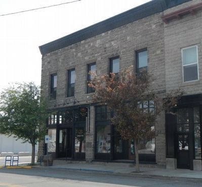
On Broadway (U.S. 12) near South Cedar Street, on the right when traveling north.
J. P. Kearns came to Townsend from Benton, Wisconsin, in 1899. Business-educated and experienced, Kearns astutely recognized the town’s need for a new financial institution and founded the State Bank of Townsend only three months later. The bank was . . . — — Map (db m141732) HM
On West Broadway at South 3rd Street, on the left when traveling west on West Broadway.
Organization of the Bridger Methodist Episcopal Church and the Ladies Aid took place in 1899, pre-dating by one year the founding of the town itself. As in other small Montana communities, itinerant ministers like the Reverend John G. Clark served . . . — — Map (db m166987) HM
On North E Street at East Broadway Avenue, on the left when traveling east on North E Street.
known as the Pillsbury House
Built 1907
has been placed on the
National Register
Of Historic Places
by the United States
Department of the Interior — — Map (db m167009) HM
On North Montana Avenue near School Street, on the left when traveling north.
Homesteaders who came to farm the Clarks Fork Valley in the early 1900s profoundly affected Fromberg’s growth, adding to its population and elevating its status as a regional trade and shipping center. Dr. Ted Benson, a recent graduate of the . . . — — Map (db m166931) HM
On Montana Avenue near School Street, on the left when traveling north.
The first Protestant services in the Clarks Fork Valley were held in 1897. The Reverend John G. Clark of Red Lodge officiated in a company boardinghouse tent at the nearby coal mining town of Gebo. By 1905, the growing congregation needed a more . . . — — Map (db m166930) HM
On West River Street near Missouri Avenue North, on the right when traveling west.
Norwegian-born immigrant John Gibson arrived in the Clarks Fork Valley at the turn of the twentieth century and soon opened brickyards in Fromberg and nearby Belfry. Gibson became one of the area’s most prominent contractors, constructing Fromberg’s . . . — — Map (db m166882) HM
On East River Street near Park Drive, on the left when traveling east.
The Gebo Mine, founded in the Clarks Fork Valley in the late 1890s, brought the tracks of the Northern Pacific to this area. The railroad, however, bypassed the coal mine and the town of Gebo that flourished near it because of difficult . . . — — Map (db m166879) HM
On West River Street near Montana Avenue, on the right when traveling west.
Jewish merchant Samuel Greenblatt moved to Fromberg from Gebo in 1900. An immigrant from Russia, Greenblatt built the town’s first commercial building. Two years later he married Jennie Hetch of Chicago at Temple Emanu-El in Helena. Greenblatt built . . . — — Map (db m166929) HM
On Hauser Avenue North near 5th Street West, on the right.
The manager of the Red Lodge Brewery, Paul Lehrkind, purchased this lot in 1920, likely with the intent of building a home. However, despite efforts to survive Prohibition by manufacturing the “near beer” Bud-O (“Always on Top”), Lehrkind was forced . . . — — Map (db m190277) HM
On Hauser Avenue North near 7th Street West, on the left when traveling north.
Over a quarter of the houses in the elite “Hi Bug” neighborhood were built between 1900 and 1901, including this one-and-one-half-story home, erected as a real estate investment by Red Lodge merchant Walter R. Hall and his wife Louisa. After leasing . . . — — Map (db m190244) HM
On Hauser Avenue North at 5th Street West, on the left when traveling north on Hauser Avenue North.
Architect Seth Hunneywell designed and built this Colonial Revival two-and-one-half-story home for Alfred and Ruth Flager, who lived here from 1902 to 1911. Costing approximately $3,500 to build and boasting “all the modern conveniences,” its “eight . . . — — Map (db m190274) HM
On U.S. 212 near Two Mile Bridge Road, on the left when traveling north.
Finnish immigrant Ephraim Kent settled in Red Lodge in the early 1900s to work in the coal mines while his wife, Fiina, began a small dairy business. It was a family venture from the start, with all the children pitching in to deliver raw milk in . . . — — Map (db m190567) HM
On Hauser Avenue North at 6th Street West, on the left when traveling north on Hauser Avenue North.
Rocky Fork Town and Electric Company sold this lot and the one next door to F. P. Musser for $84 in 1896. Immediate resale to real estate agent T. P. McDonald for $177 netted Musser a handsome profit. This four-square cottage was either moved or . . . — — Map (db m190247) HM
On Hauser Avenue North near 7th Street West, on the left when traveling north.
“Coziness” was the watchword of progressive builders in the early twentieth century. Small, well-designed houses proliferated after 1900 in part to compensate for the expense of such modern conveniences as indoor plumbing. Plans for . . . — — Map (db m190227) HM
On Hauser Avenue North near 6th Street West, on the left when traveling north.
Michigan-born attorney George Pierson and his wife Loretta moved to Red Lodge in 1894. Soon thereafter they purchased this lot, where they lived in a one-story cottage. After the Piersons decided to build this “Free Classic” Queen Anne style . . . — — Map (db m190248) HM
On Word Avenue North at 7th Street West, on the left when traveling north on Word Avenue North.
Prominent Red Lodge businessman William B. Nutting subdivided this northwestern neighborhood as the Nutting Addition circa 1899. Beginning in 1900 with this home, he built five cottages north of his own residence that became known as Nutting Row. J. . . . — — Map (db m190443) HM
On Hauser Avenue North at 5th Street West, on the right when traveling north on Hauser Avenue North.
A steep-roofed gable-front cottage with a wraparound porch stood on this lot by 1901. Sometime before 1907 Rose Robbins—who owned the one-and-one-half-story home along with many other lots in the neighborhood—expanded the residence, adding a rear . . . — — Map (db m190275) HM
On Hauser Avenue North near 7th Street West, on the left when traveling north.
A prestigious corner site contributes much to the elegance of this Queen Anne style cottage, built by rancher and businessman Louis Sichler in 1902. The steep and asymmetrical roofline, projecting gables, and two-storied bay epitomize the Queen Anne . . . — — Map (db m190245) HM
On Hauser Avenue North near 3rd Street West, on the right when traveling north.
W. A. Talmage arrived in Red Lodge in 1888 to manage a branch of a Billings mercantile. By 1894, the ambitious businessman owned his own large hardware and farm implements store on Billings Avenue. Undoubtedly, his business connections helped . . . — — Map (db m190436) HM
On Hauser Avenue North at 6th Street West, on the left when traveling north on Hauser Avenue North.
According to an oral tradition handed down in the Crockett family, this gable-front cottage was moved here from “Old Town.” It was remodeled circa 1901 when it is first recorded on this lot. At that time, prominent merchant W. A. Talmage owned the . . . — — Map (db m190246) HM
On Main Street near Munro Avenue, on the left when traveling east.
In 1934, at the height of the Great Depression, fire destroyed four Main Street buildings, including the First National Bank. When the economy recovered, local contractor V. E. Figg designed and constructed this 1940 commercial structure. With . . . — — Map (db m164217) HM
On 3rd Avenue North near 3rd Street North, on the left when traveling west.
A graceful wraparound porch with square posts, a central entry beneath a projecting gable, and transomed windows distinguish this charming vernacular example of the Greek Revival style. Inside, a rounded hall ceiling adds lovely period elegance. The . . . — — Map (db m143826) HM
On 4th Avenue North near 4th Street North, on the right when traveling west.
Great Falls’ premier residential street, Fourth Avenue North, gained 24 new homes between 1900 and 1910. Among them was this substantial residence, constructed in 1904 for bookkeeper Edgar Newlon and his wife Anna. The home is a classic American . . . — — Map (db m143823) HM
On 4th Ave North near 7th Street North, on the right when traveling west.
Pictured in 1909 in the Great Falls Tribune under the headline “A Great Falls Residence,” this Queen Anne style house was hardly typical of its day. An imposing two-and-one-half-story structure, the elegant home was built in 1901 for . . . — — Map (db m143815) HM
On 4th Avenue North near 7th Street North, on the right when traveling west.
A dramatic living room fireplace, crystal chandelier, and boxed-beam dining room ceiling are among the original fixtures continuing to decorate the interior of the Abe and Carrie Kaufman residence. Neoclassical, Craftsman, and Victorian detailing . . . — — Map (db m143816) HM
On 3rd Avenue North at 3rd Street North, on the left when traveling west on 3rd Avenue North.
The Boston and Montana Consolidated Copper and Silver Mining Company, later acquired by the Anaconda Company, chose a treeless bluff overlooking the river to locate its smelter and refinery in 1892. Among the seventeen managers’ houses built at . . . — — Map (db m143828) HM
On 1st Avenue South near 2nd Street South, on the left when traveling west.
During the busy 1890s, Great Falls’ business district swarmed with activity. City boosters such as pioneer rancher Robert Vaughn expressed confidence in the town’s future by investing in commercial real estate. Vaughn commissioned an unknown . . . — — Map (db m143679) HM
On 2nd Street North near 3rd Avenue North, on the right when traveling north.
By 1910, the Queen Anne style had lost much of its allure. Once admired, its artistic jumble of angles, textures, and colors had become reviled as cluttered and artificial. This rejection of complexity was gradual, and many houses—like this . . . — — Map (db m143856) HM
On 4th Avenue North near 9th Street North, on the right when traveling west.
Charles E. Davis, “expert watchmaker and jeweler,” arrived in Great Falls with his wife, Grace, in 1900. With Charles’ two brothers, the couple opened a store on bustling Central Avenue, selling jewelry, watches, cut glass, gifts, and . . . — — Map (db m143805) HM
On 2nd Avenue North, 0.1 miles east of 5th Street North, on the right when traveling east.
Spirited revelry in the streets of Great Falls greeted news of the creation of Cascade County in 1887.
Named county seat, Great Falls grew quickly, with county offices located in various downtown buildings.
In 1891 voters approved the . . . — — Map (db m101873) HM
On 1st Avenue North near 9th Street North, on the right when traveling west.
A shortage of steel and limited purchases of nonessential goods during World War II caused the automobile industry to skyrocket after the war ended. As the troops came home and the economy recovered, Montana experienced this boom as well. By the . . . — — Map (db m143772) HM
On Central Avenue near 5th Street South, on the right when traveling east.
A close look at the Woolworth Building’s upper floors makes evident that it was originally two separate, but closely related edifices. Connecting arches over second-story windows, a decorative metal cornice, and a crowning brick parapet distinguish . . . — — Map (db m143769) HM
The pioneer Methodist circuit rider William Wesley Van Orsdel—better known as “Brother Van”—arrived in Fort Benton, Montana, on the steamboat, Far West, in 1872. For forty-five years, he traveled on horseback, by wagon, by rail, and, finally, as a . . . — — Map (db m143788) HM
On Central Avenue at 5th Street, on the left when traveling west on Central Avenue.
An eclectic cultural landscape has long characterized the West Bank. Separated from downtown Great Falls by the broad Missouri River, the larger neighborhood has hosted a varied mix of industrial, residential, and commercial development since the . . . — — Map (db m143758) HM
On Park Drive South at Central Avenue, on the right when traveling south on Park Drive South.
Clean lines, formal monumental openings, and restrained revival details mark the 1939 Great Falls Civic Center as a municipal Art Deco style building. The Works Projects Administration provided most of the funding for the building. The . . . — — Map (db m143680) HM
On 6th Avenue South near Central Avenue, on the right when traveling south.
Beneath the façade of this solid-looking building stands a much older wooden boarding house. In 1891, only seven years after the founding of Great Falls, a two-story dwelling stood on this lot. Mrs. S. H. Lemon ran the boarding house in 1896 and . . . — — Map (db m143770) HM
On Central Avenue near 3rd Avenue South, on the right when traveling west.
Thirty-six hundred people watched Nomads of the North at the grand opening of the Liberty Theatre in August 1921. A musical score, played on a $47,000 Wurlitzer organ, accompanied the silent film. An overflow crowd of two thousand toured the . . . — — Map (db m143756) HM
On Central Avenue at 9th Street North, on the right when traveling west on Central Avenue.
Freemasons trace their history to the stonemasons of Medieval Europe, an association referenced in the design for the Great Falls Masonic Temple. Constructed in 1914, the three-story building features a dramatic central tower and steep gable bays . . . — — Map (db m143771) HM
On 3rd Avenue North near 3rd Street North, on the left when traveling west.
Carroll B. McCulloh and his wife Ella constructed this elegant two-story brick home in 1911, raising their two children here. Its two-and-one-half stories, simple box shape, low-hipped roof, large central dormer, wide overhanging eaves, and offset . . . — — Map (db m143855) HM
On Central Avenue near 2nd Street South, on the right when traveling north.
In the 1880s Murphy, Maclay and Co. sold everything from flour and fine teas to window glass and blasting powder. Edgar Maclay and John Murphy established the firm with stores in Helena and Fort Benton in 1882. Two years later they sent Worden Wren . . . — — Map (db m143754) HM
On Central Avenue at Park Drive North, on the left when traveling west on Central Avenue.
Town founders Paris Gibson and Herbert Chowen built the original Park Hotel in 1892 to serve travelers disembarking at the nearby Great Northern Depot. When the hundred-room hotel burned in a 1913 fire, Park Hotel owners hired prominent Great Falls . . . — — Map (db m143753) HM
On 4th Avenue North near Park Drive North, on the right when traveling west.
Great Falls founder Paris Gibson was drawn to the power of the falls of the Missouri where he vowed to found an industrial center of “unsurpassed beauty.” Backed by railroad magnate James J. Hill, Gibson hired H. P. Rolfe to plat the . . . — — Map (db m143857) HM
On 4th Avenue North near 7th Avenue North, on the right when traveling west.
By 1908, Montana’s agricultural boom was in full swing, and real estate agents like John Quigley, whose firm offered farms “on 20 years payments,” seemed poised to make a fortune. That year forty-eight-year-old Quigley built this large . . . — — Map (db m143807) HM
On Central Avenue near 4th Street North, on the right when traveling west.
Thirty-six hundred people watched Nomads of the North at the grand opening of the Liberty Theatre in August 1921. A musical score, played on a $47,000 Wurlitzer organ, accompanied the silent film. An overflow crowd of two thousand toured the . . . — — Map (db m143757) HM
On 2nd Avenue Northwest at 10th Street Northwest, on the right when traveling west on 2nd Avenue Northwest.
Irish-born Timothy Collins followed the gold stampedes to Montana but soon turned to law and politics. For a time in the 1870s he was the only attorney practicing in Meagher County. Elected to the territorial legislature several times, Collins was a . . . — — Map (db m143677) HM
On 4th Avenue North at 3rd Street North, on the left when traveling west on 4th Avenue North.
Apartment buildings were good investments in rapidly expanding communities like Great Falls, which grew from 17,000 to 26,000 between 1910 and 1920. Owners reported waiting lists for units, which ranged from rooms in old-fashioned “apartment . . . — — Map (db m143824) HM
On 4th Avenue North, on the left when traveling west.
The front canted bay window hints at the modest one-story Queen Anne style residence that lies at the core of this elegant home. In 1891, the house was one of only two on the block. A small back addition had been added by 1900, when Mandeville . . . — — Map (db m143822) HM
On 5th Avenue South near 9th Street South, on the right when traveling east.
At the center of the African American community in Great Falls for more than a century, the Union Bethel AME Church began holding regular services in the first fire station in 1890. The following year African American residents gathered with white . . . — — Map (db m143792) HM
On 4th Avenue North near 9th Street North, on the right when traveling west.
A grand home on a large corner lot, this Colonial Revival residence bespeaks the prominence of its first owners. Banker, rancher, and state senator William Floweree and his wife, Norma, built this brick two-and-one-half-story home in 1916. Its . . . — — Map (db m143806) HM
On 3rd Street Northwest near 3rd Avenue Northwest, on the right when traveling west.
William and Isabel Shea built this cozy one-story brick home in 1929. With its distinctive low profile, clipped-gable shingle roof, stucco siding, exposed rafter tails, and multi-pane windows, the inviting residence is a classic Craftsman style . . . — — Map (db m143670) HM
On Franklin Street near 13th Street, on the left when traveling east.
Minneapolis architects Kees and Fisk drew the plans for this magnificent Queen Anne style courthouse which opened in 1884. As the seat of one of Montana's nine original counties, its grand appearance represents the early affluence of this "Chicago . . . — — Map (db m142451) HM
On Front Street near 15th Street, on the right when traveling north.
Solomon's Medicine Lodge Saloon was remodeled in 1875 and became the Centennial Hotel. This frame building was moved to the back of the lot by Robert S. and Lydian Smith Culbertson for living quarters, while a new two-story brick hotel was built . . . — — Map (db m142303) HM
On Front Street near 15th Street, on the left when traveling north.
Originally this site was occupied by a wooden frame building that housed Mose Solomon’s Medicine Lodge. This legendary saloon was open twenty-four hours a day from spring thaw to first snow. When the building burned, prominent lawyer, customs . . . — — Map (db m161662) HM
Fort Benton’s building boom of 1887-1884 saw the construction of many commercial buildings made of locally produced soft brick. This fine example was built in 1881 as a saddlery by Davidson and Moffitt of Helena. The River Press Company, publisher . . . — — Map (db m142064) HM
On Front Street near 15th Street, on the right when traveling east.
The Fort Benton Engine House, built in 1883, and the Grand Union Hotel are two of only a few structures remaining to remind us of the rapid expansion here during the flourishing steamboat days. When Fort Benton incorporated in 1883, a volunteer fire . . . — — Map (db m142417) HM
On 14th Street at Front Street, on the left when traveling north on 14th Street.
This grandiose, three-story Italianate style hotel welcomed weary river travelers to the Gateway of the Northwest, offering guests a luxurious refuge before setting out for less civilized destinations. Its opening in 1882 came at the end of the . . . — — Map (db m142062) HM
On Front Street near 16th Street, on the left when traveling north.
From the 1850s to 1887, Fort Benton was the trade center for this region of the American and Canadian West. Like others who chose to stay when the fur trade declined, I.G. Baker (last American Fur Company factor at the fort) turned to new endeavors. . . . — — Map (db m142133) HM
On Front Street near 17th Street, on the right when traveling north.
The original portion of this house, one of the oldest in Montana, was built for I.G. Baker in 1867. Early-day Fort Benton merchant Baker wanted a home, rather than the old fort for the birth of his expected child.
Constructed of rough-sawn . . . — — Map (db m142290) HM
On Front Street near 14th Street, on the left when traveling north.
Members of Masonic Lodge #25 built this brick structure in 1882, housing their temple on the second floor. Grocer W. H. Burgess rented first floor space. Economic decline in the late 1880s caused the Masons to lose title, and Burgess, too, went . . . — — Map (db m142103) HM
On Front Street near 15th Street, on the left when traveling north.
Originally built to house the Stockmen’s National Bank, this solid structure represents typical pre-1900s commercial architecture. Its 1890 construction is significant as one of the few buildings erected after Fort Benton’s heyday and before . . . — — Map (db m142102) HM
On Front Street at 14th Street, on the left when traveling north on Front Street.
Originally built to house the Stockmen’s National Bank, this solid structure represents typical pre-1900s commercial architecture. Its 1890 construction is significant as one of the few buildings erected after Fort Benton’s heyday and before . . . — — Map (db m142101) HM
On Front Street near 17th Street, on the left when traveling north.
In 1867, merchant T. C. Power, destined to become one of the state’s wealthiest and most influential men, brought his first wagonload of goods to Fort Benton, where he set up shop in a borrowed tent. Still in business in 1916, Power constructed a . . . — — Map (db m142137) HM
On Front Street at 17th Street, on the right when traveling north on Front Street.
Originally a pretentious two-story frame hotel familiar to all rivermen, the Choteau House was built in the spring of 1868. T.C. Power and I.G. Baker constructed the building between their businesses to rival Overland up the street.
At . . . — — Map (db m142289) HM
On Virgelle Ferry Road North, on the left when traveling north.
Homesteaders, travelers, and railroad crews helped the tiny town of Virgelle thrive during the 1910s. Town founder Virgil Blankenbaker chartered the Virgelle State Bank in 1917 where he, his brother-in-law John G. Chancellor, C. J. McNamara, and . . . — — Map (db m161664) HM
On Palmer Street at North 10th Street, on the left when traveling east on Palmer Street.
E. H. Johnson, state legislator and Miles City’s first mayor, built this impressive modified Queen Anne style home in 1887. Attributed to Miles City architect Byron Vreeland, the irregular plan originally featured an elaborate arched porch and an . . . — — Map (db m164045) HM
On Main Street (State Highway 59) near South Jordan Avenue, on the right when traveling east.
High maintenance steam engines required railroads to locate large repair shops every two hundred miles. After the Chicago, Milwaukee, St. Paul and Pacific Railroad chose Miles City for a division point in 1907, the town grew rapidly. Population . . . — — Map (db m164145) HM
On Palmer Street at North 11th Street, on the left when traveling east on Palmer Street.
Nannie Alderson came to Montana from Kansas with her husband Walt in 1883. They operated a cattle ranch for a decade but moved to Miles City in 1893 so their children could attend school. In 1895, Walt died from head injuries after he was kicked by . . . — — Map (db m164048) HM
On Main Street (State Highway 59) near North Strevell Avenue, on the left when traveling east.
Real estate speculation abounded in the East Main district when carpenter Ernest Anderson built this lovely one- and-a-half-story bungalow in 1916. Its large front porch, supported by heavy, tapered columns, and its low- pitched roofs with . . . — — Map (db m164150) HM
On Pleasant Street at North 10th Street, on the right when traveling east on Pleasant Street.
This gracious, historic residential neighborhood illustrates Miles City's prosperity as it evolved from a frontier town into the livestock, transportation, commercial, and governmental hub of eastern Montana. Businessmen and community leaders built . . . — — Map (db m164093) HM
On South 8th Street at Bridge Street, on the right when traveling south on South 8th Street.
The transformation of Miles City in the early 1900s into the economic, social, and governmental center of the valley precipitated the decision to build a permanent city hall. Ed Arnold, tailor and businessman, became one of the motivating forces . . . — — Map (db m164043) HM
On M (State Highway 59) near South Strevell Avenue, on the right when traveling east.
The steamer Far West carried Irish immigrant James Coleman to Fort Keogh in 1876. After working for the army sutler, Coleman moved into Miles City, where he managed a saloon frequented by army regulars. In 1882, he married his Irish bride, Margaret . . . — — Map (db m164146) HM
On Main Street near North Cottage Avenue, on the right when traveling east.
Hardware store owner, banker, and real estate developer George Miles, nephew of Colonel Nelson A. Miles, hired a contractor to build this hipped-roof cottage around 1910. Following completion of the Chicago, Milwaukee, St. Paul and Pacific Railroad . . . — — Map (db m164215) HM
On Main Street (State Highway 59) at North Merriam Avenue, on the left when traveling east on Main Street.
A sophisticated blend of Classical elements characterizes this intimately elegant residence that, despite its modest size, easily rivals the district’s grander “high style” homes. Built in 1907, the residence was then “out in the country,” its . . . — — Map (db m164168) HM
On Main Street (Business Interstate 94) near South 5th Street, on the right when traveling east.
Dr. Robert G. Redd served as an army surgeon at Fort Keogh in the 1870s. Redd resigned in 1881 to assume a private practice. He served as county physician, coroner, and surgeon for the Northern Pacific Railroad as well as mayor from 1889 to 1900. He . . . — — Map (db m163878) HM
On Main Street (State Highway 59) near North Winchester Avenue, on the left when traveling east.
Wealthy Miles City residents looked to the undeveloped area east of the Northern Pacific tracks to build their homes in the early twentieth century. Among them were Ed and Doris Love who had this Prairie Style home constructed in 1916. Its bands of . . . — — Map (db m164149) HM
On North 11th Street at Palmer Street, on the right when traveling north on North 11th Street.
An eclectic blend of Romanesque, Gothic, and Queen Anne architectural styles, this 1886 church survives as designer Byron Vreeland’s most significant building in Montana. Vreeland blended these styles as his architectural signature in many of his . . . — — Map (db m164049) HM
On Main Street (Business Interstate 94) at North Montana Avenue, on the left when traveling east on Main Street.
Charter members George and Helen Miles bestowed this land on the church in 1882. Since that time the First Presbyterian Church has occupied this space. Church trustees met in 1911 to discuss the construction of a larger $30,000-$40,000 church. . . . — — Map (db m164116) HM
On Main Street (Highway 59) near South Custer Avenue, on the right when traveling east.
This American foursquare style home appears to have been designed by prominent architect Brynjulf Rivenes. Built between 1910 and 1914 for businessman George Foster, its compact simplicity is an elegant, individual statement of the prosperity Miles . . . — — Map (db m164119) HM
Born in Wisconsin, Al Furstnow settled permanently in Miles City in 1894 and became the major saddler in the northwest. In 1895, Furstnow commissioned Byron Vreeland to build this Queen Anne style home, unusual because the architect usually designed . . . — — Map (db m164091) HM
On Main Street (State Highway 59) at South Lake Avenue, on the right when traveling east on Main Street.
Cabinet and furniture makers also made caskets, and so the two businesses often went hand in hand. Furniture dealer James E. Graves purchased H. C. Plimpton’s long-established furniture and undertaking business in the 1920s. In 1929, Graves moved . . . — — Map (db m164118) HM
On Main Street (State Highway 59) near South Jordan Avenue, on the right when traveling east.
The stylistic versatility of architect Brynjulf Rivenes is well demonstrated in this distinguished home built for Miles City businessman Harry J. Horton. The simple foursquare plan combines wide eaves, a low hipped roof, and massive brick pillars, . . . — — Map (db m164121) HM
On North Jordan Avenue near Clark Street, on the right when traveling north.
A converted two-story house served as the county hospital in 1907, a year before the Chicago, Milwaukee, St. Paul and Pacific Railroad arrived in Miles City. With encouragement from the railroad, which needed a place to treat injured workers, the . . . — — Map (db m164171) HM
On Main Street (Business Interstate 94) near South 8th Street, on the right when traveling east.
The Jackson Block’s spare façade bears witness to those watchwords of modern architecture, “form follows function.” The two-story building suggests ways that urban architectural trends were translated and adapted in small communities. Its main . . . — — Map (db m164044) HM
On Pleasant Street at North 9th Street, on the left when traveling east on Pleasant Street.
Complex rooflines and decorative details define this wood-frame residence. Particularly noteworthy are the ornamental bargeboards fastened to the roofline and the unique bull’s-eye pattern decorating the front gable. Other details include windows . . . — — Map (db m164095) HM
On North Cottage Grove Avenue near Main Street, on the left when traveling north.
Sometimes called “labor’s aristocracy,” locomotive engineers were the highest paid workers on the railroad. That fact gave William Kelly, an engineer for the Milwaukee Road, the means to purchase this one-story home. In 1920 he lived here with his . . . — — Map (db m164172) HM
On Main Street (Business Highway 94) near South 6th Street, on the right when traveling east.
This popular gathering place, one of Miles City’s oldest established businesses, has been proclaimed by connoisseurs the perfect bar. Originally a saloon (1893), then a fine saddlery (1900-1907), businessman James Kenney purchased the property in . . . — — Map (db m163980) HM
On North 11th Street near Palmer Street, on the right when traveling north.
The end of the 1880s witnessed development of Miles City’s north side, with expensive homes being built on generous tracts of land. As land became scarce, parcels were carved from spacious lawns and working families became the neighbors of prominent . . . — — Map (db m164090) HM
On Main Street (State Highway 59) at South Stacy Avenue, on the right when traveling east on Main Street.
Built for C. N. and Louise E. Lukes in 1911, the home is also known as the Ed Love House. Lukes was cashier of the Commercial State Bank and after the deaths of C. N. and Louise in 1929, ownership passed to their daughter, Doris Lukes Love, and her . . . — — Map (db m164148) HM
On Palmer Street near North 11th Street, on the left when traveling east.
Nestled amidst grand Queen Anne style houses is this early folk residence. The wooden home, constructed for Scottish immigrant John McAusland, appears on an 1883 bird’s-eye map of Miles City. A steeply pitched side-gable roof and a small dormer . . . — — Map (db m164046) HM
On North 11th Street at Pleasant Street, on the right when traveling north on North 11th Street.
In 1910, the Methodists hired a New York fundraising firm to raise funds for a new, larger church to replace the 1883 building. The growing congregation raised $14,000 and neighbor C. J. Wagenbreth donated the needed capital to complete the project, . . . — — Map (db m164092) HM
On Main Street (State Highway 59) near South Jordan Avenue, on the right when traveling east.
The development of this elegant residential neighborhood reflects Miles City's second growth spurt in the early twentieth century. Although the population of this "cowtown" waned between 1890 and 1905, the advent of the Chicago, Milwaukee and St. . . . — — Map (db m164120) HM
On Main Street (Business Interstate 94) near South 6th Street, on the right when traveling east.
The Main Street historic district reveals Miles City’s major growth periods of 1882-1887, 1905-1920, and 1935- 1940. The first of these began with the arrival of the Northern Pacific in 1881, when imposing brick business blocks began to replace the . . . — — Map (db m163979) HM
On Main Street (State Highway 59) near South Custer Avenue, on the right when traveling east.
A low-pitched hipped roof, an asymmetrical open front porch with massive square porch supports, clean lines, and wide overhanging eaves mark the two-story Pope residence as a classic example of the Prairie style. Builder Thomas Burton clad the . . . — — Map (db m164117) HM
On Main Street (State Highway 59) at North Jordan Avenue, on the left when traveling east on Main Street.
Nature, comfort, simplicity, honesty, and integrity were ideals incorporated into early-twentieth-century architecture. This Craftsman style bungalow is an exceptional expression of those ideals. Its compact floorplan and modestly adorned exterior . . . — — Map (db m164169) HM
On Main Street (State Highway 59) at South Strevell Avenue, on the right when traveling east on Main Street.
Determined to bring the Chicago, Milwaukee, and St. Paul Railroad to Miles City, land developer, cattleman, and banker Lorenzo Stacy organized his fellow businessmen to secure and donate property for the railroad’s right-of- way. In 1908, the . . . — — Map (db m164147) HM
On Main Street at North 5th Street, on the left when traveling east on Main Street.
Since the 1880s, Miles City has been the trade, service, and social center for Eastern Montana ranchers. After its famed McQueen House burned down, town booster Joseph Leighton built the Leighton, 1898-1899, which became an area landmark. Within a . . . — — Map (db m163974) HM
On South Strevell Avenue at Stower Street, on the right when traveling north on South Strevell Avenue.
Armed with a degree from the Ontario Business College, Canadian-born Thomas Shore arrived in Miles City in 1896. He and former cowboy Wirt Newcom formed a partnership and opened a department store on Main Street in 1900. The store flourished, . . . — — Map (db m164174) HM
543 entries matched your criteria. The first 100 are listed above. Next 100 ⊳