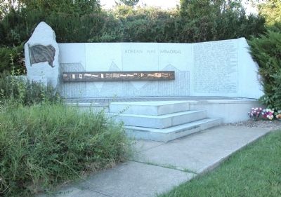
On McNeely Lake Drive (Park Road) 0.4 miles south of Cooper Chapel Road, on the right when traveling south.
KOREAN WAR MEMORIAL
JUNE 25, 1950 - North Korean Communist troops crossed the 38th Parallel, invading South Korea. Within days, the South Korean capital of Seoul fell into Communist hands.
SEPTEMBER 15, 1950 - Allied troops make very . . . — — Map (db m35357) WM
On West Jefferson Street near South 5th Street, on the right when traveling west.
One of three original counties formed when Kentucky Co., Virginia, was divided by Va. Act in 1780. Other 2 counties were Lincoln and Fayette. Jefferson included 19 present-day counties; parts of 11 others. By 1811 reduced to present boundaries. . . . — — Map (db m205257) HM
Near South College Street (U.S. 127) at West Lexington Street, on the right when traveling south.
The Lincoln family first came to America in the seventeenth century, originally settling in the Massachusetts Bay colony. The Lincolns continued to move throughout the colonies, settling in present-day New Jersey, Pennsylvania, and Virginia. Thomas . . . — — Map (db m46319) HM
On Main Street (U.S. 60) at 5th Street, on the left when traveling east on Main Street.
Formed from a part of Jefferson County, it was the third created after Kentucky became a state. Named in honor of Isaac Shelby, 1750-1826, first Kentucky governor, 1792-96; elected again 1812-16. In the Revolutionary War, Indian campaigns, and War . . . — — Map (db m136872) HM
Near West Jefferson Street at South 6th Street, on the right when traveling east.
Born in Louisville and educated at Male High School. Graduated first in Harvard Law School, class of 1877. Practiced law in Boston where he championed the rights of individuals and was known for his social activism. First Jew appointed to U.S. . . . — — Map (db m179129) HM
On S 2nd Street at W Main Street, on the right when traveling north on S 2nd Street.
Slave Trading In Louisville. By the 1850s, Kentucky was annually exporting between 2500 and 4000 of its slaves down river to the large plantations further south. To prevent runaways, traders operating near the Ohio River kept slaves shackled . . . — — Map (db m104173) HM
Slavery Laws In Old Kentucky. Ky.'s 1792 Constitution continued legalized enslavement of blacks in the new state; 1800 tax lists show 40,000 slaves. U.S. banned African slave trade in 1808 but selling of men, women and children in South . . . — — Map (db m103609) HM
Near South College Street (U.S. 127) at West Lexington Street, on the right when traveling south.
The marriage of Thomas Lincoln and Nancy Hanks took place on the Beechland property of Nancy’s uncle, Richard Berry Sr., in Washington County, about twenty-five miles southwest of here, on June 12, 1806. The ceremony was presided over by the . . . — — Map (db m46317) HM
On Lincoln Park Road (Kentucky Route 528) south of Fairlane Drive, on the left when traveling south.
Mordecai Lincoln, uncle to President Abraham Lincoln, lived in this house from around 1797 to 1811.
His father, Captain Abraham Lincoln, the grandfather and namesake of the future president, came to Jefferson County, Virginia, in 1782. In . . . — — Map (db m46243) HM
Near Wilkinson Boulevard (U.S. 421) north of West Plaza Connector Road (U.S. 127), on the right when traveling south.
Frankfort takes its name-many people believe-from an episode that took place near here during the frontier era. A group of explorers camping near the mouth of Benson Creek was attacked by Indians. One member of the group, Stephen Frank, was killed. . . . — — Map (db m62266) HM
On Shelbyville Road (U.S. 60) at Whipps Mill Road, on the right when traveling west on Shelbyville Road.
Fort William
Established in 1785 by William Christian and his wife, Anne, a sister of Patrick Henry. On this site one of earliest stone houses in Kentucky was a famous tavern, The Eight Mile House, on Harrods Trace to Falls of the Ohio. From . . . — — Map (db m161983) HM
On Beechland Road (Kentucky Route 438) at Lincoln Park Road ( Route 528), on the left when traveling east on Beechland Road.
Pioneer Spirit
The westward movement was an enticement felt by many nineteenth century families, and the Lincolns were in the heart of it. A friend of the family was the infamous frontiersman Daniel Boone, and it has been reasoned that . . . — — Map (db m46249) HM
On W Main Street at N 6th Street, on the right when traveling west on W Main Street.
A native of Wales, Williams came to Kentucky around 1780. In 1783, he built his distillery on the banks of the Ohio River, distilling whiskey from corn on the east side of what is now 5th Street. It is said to have been the first commercial . . . — — Map (db m104373) HM
On West Main Street west of South 1st Avenue, on the right when traveling east.
Oldham was the 75th county created by the Kentucky Legislature. It was formed on January 15, 1824, from portions of Jefferson, Henry and Shelby Counties. The county is named for William Oldham, Revolutionary War patriot and early pioneer.
. . . — — Map (db m136163) HM
Near Baxter Avenue (U.S. 31E/150) at Cherokee Road, on the right when traveling north.
Born in Richmond, Va., on October 29, 1810, Wolfe was one of the first two graduates of
the University of Virginia School of Laws in 1829. After law school, he came to Kentucky to begin his law practice. He was a highly respected criminal . . . — — Map (db m161217) HM
On Breckenridge Lane (State Road 1932) at Hillsboro Road, on the right when traveling south on Breckenridge Lane.
Grave of John Floyd, near here. Pioneer and surveyor. Born Amherst County, Virginia, 1750. Killed when ambushed by Indians in Jefferson County, District of Kentucky, 1783. Colonel of Militia and County Lieutenant of Jefferson County. — — Map (db m161996) HM
On Louisville/Bardstown Road (U.S. 31E/150) 0 miles north of Wheeler Wright Lane, on the right when traveling north.
The first settlement in Nelson County, KY. Three miles east of this spot stood Cox's Station, established in 1775 by Colonel Isaac Cox, a Colonial and Revolutionary War officer who came from Virginia to Kentucky and who was killed by the Indians in . . . — — Map (db m74267) HM
On E Andrew Johnson Highway (U.S. 11), on the right when traveling east.
0.4 mi. Built 1785 by Col. James Roddye, from North Carolina. He was subsequently delegate to the North Carolina Constitutional Convention, magistrate and register of Jefferson County under territorial government and member of Tennessee's first . . . — — Map (db m81632) HM
On South 2nd Street (Kentucky Route 1020) at West Cardinal Boulevard, on the left when traveling north on South 2nd Street.
Between 1750 and 1840, British colonists and later United States citizens acquired and settled millions of square miles between the Appalachian Mountains and the Mississippi River. The Ohio River bisects this vast region, flowing 981 miles from . . . — — Map (db m245720) HM
On South 3rd Street south of West Cardinal Boulevard, on the left when traveling south.
The United States faced two fundamental tasks during the Reconstruction period (1865-1877). One was the need to redefine and renormalize relations between the former Confederate states and the rest of the nation. The other was to redefine the role . . . — — Map (db m245713) HM
On Westport Road (Kentucky Route 524) at 4th Street, on the right when traveling west on Westport Road.
First called Liberty, located on 1780 grant to Elijah Craig. Ferry operated here by Levi Boyer early as 1800 formed a link in route to Illinois country. Town became a port to the west -- Westport. In the steamboat era, the town was a thriving port . . . — — Map (db m42974) HM
Throughout the nineteenth century, Kentucky led the nation in hemp production. By the 1830s, Farmington was 550-acre working hemp plantation - a center of agriculture and industry. Hemp, the most labor-intensive crop grown in the state, perpetuated . . . — — Map (db m244654) HM
On Short Street just west of South Main Street, on the left when traveling west.
Harrodsburg
1774 ~ Laid off as Harrodstown by James Harrod and companions. First permanent English settlement west of the Alleghany Mountains.
1776 ~ Virginia Legislature formed Kentucky County, the area now Commonwealth of Kentucky, . . . — — Map (db m152644) HM
Near Beechland Road (Kentucky Route 438) at Lincoln Park Road ( Route 528), on the left when traveling east.
Thomas Lincoln
Thomas Lincoln was born on January 7, 1778, in Rockingham County, Virginia, to Captain Abraham and Bathsheba Lincoln. He was the youngest of three sons and the fourth of five children. The Lincoln family migrated from . . . — — Map (db m46311) HM
Near Beechland Road (Kentucky Route 438) at Lincoln Park Road ( Route 528), on the left when traveling east.
The Lincoln Cabin is a replica of the cabin in which President Abraham Lincoln’s grandmother Bersheba Lincoln, lived and raised her children after the death of her husband, Abraham.
In the spring of 1786, Abraham and Bersheba Lincoln were . . . — — Map (db m46305) HM
Near Beechland Road (Kentucky Route 438) at Lincoln Park Road ( Route 528), on the left when traveling east.
President Abraham Lincoln’s great, great, great, great grandfather, Samuel Lincoln, left England in 1637, settling in Hingham, Massachusetts. The next four generations of Lincolns continued to move south and west — to New Jersey, then . . . — — Map (db m46301) HM
On Rankin Hill Road (County Route 556) 1.5 miles east of North Second Street, on the right when traveling south.
John Rankin was born in Jefferson County, Tennessee, and lived in the state through college, his marriage, and his beginning as a minister. He was often opposed by congregations for frequently sharing his anti-slavery beliefs from the pulpit. In . . . — — Map (db m273122) HM
On Morgan Jaymes Drive west of Justine Court, on the right when traveling west.
This small family cemetery is all that remains of what was once Joseph Hite's 1000 acre estate. Joseph's son and intended heir, Stephen Hite (1700-1828), is buried here. Stephen's wife, Martha (1798-1830), and daughter, Sarah (1824-1827), are also . . . — — Map (db m223424) HM
Formed from parts of Breathitt, Morgan, Owsley, Powell counties. It was the 110th created.
Named for Nathaniel Wolfe, 1810-65, a native of Virginia, reported to be first graduate of the University of Virginia. In Kentucky, he was . . . — — Map (db m73874) HM
On Kanawha Trail (Virginia Route 311) 0.3 miles south of Sweet Springs Lane, on the right when traveling south.
Just over the state line in West Virginia is the grave of physician and politician John Floyd. He was born in Jefferson County, Virginia (now Kentucky), on 24 Apr. 1783. He married Laetitia Preston in 1804 and received his medical degree from the . . . — — Map (db m295842) HM
On Sweet Springs Valley Road (West Virginia Route 3) at Kanawha Trail ( Route 311), in the median on Sweet Springs Valley Road.
Born, Jefferson County, Kentucky, April 24, 1783 a distinguished son of the American frontier, he served his nation as a soldier, physician, and legislator. Following service as an officer in the Virginia Militia, and as a surgeon in the War of . . . — — Map (db m34486) HM
On West Main Street (U.S. 31W) just east of South 3rd Street, on the left when traveling west.
Distillery owner Richard Cummins built a second facility next to Coon Hollow called Big Springs. By the 1890s, the two distilleries had six bonded warehouses containing some 25,000 barrels of whiskey.
In addition to their own brands, the . . . — — Map (db m178301) HM
On Bethesda Road, on the right when traveling north.
(Front Side):
Early Russellville (1780-1859) The Russellville area was settled shortly after the American Revolution. The first pioneers probably were in the area by 1780-1782, when the land was still known as Indian Territory. Early . . . — — Map (db m25476) HM
Born in Jefferson County, Kentucky, Governor Ray studied law at the University of Cincinnati and established a practice in Brookville, Indiana.
Prior to being elected governor, he served one term as a state representative and two terms as a state . . . — — Map (db m76580) HM
Near Taylorsville Road (State Road 155), on the right when traveling west.
Kentucky's oldest civil airport was first used in 1919. Army Air Corps Reserve unit established three years later. Double hangars (west) housed 325th Observation Squadron. Terminal building, erected in 1929, was used by airlines through 1947. . . . — — Map (db m162001) HM
On W Jefferson Street at S 5th Street, on the right when traveling west on W Jefferson Street.
City and County Named. Louisville, at the Falls of the Ohio, was founded in 1778 by George Rogers Clark. Site first served as a military outpost; the city which developed was named for Louis XVI. Kentucky Co., Virginia, was divided in 1780 . . . — — Map (db m104581) HM
On Capital Street 0.1 miles south of East 4th Street, on the right when traveling south.
At Deadwood on August 2, 1876, Jack McCall shot "Wild Bill" Hickok in the back of his head. When a vigilante court tried him, he claimed Bill had killed his brother and the vigilantes let him go. Later, due to his boasting, at Laramie City, US . . . — — Map (db m177712) HM
In Whose Honor Jefferson County, Texas
Was Named Chief Justice of Calhoun County
1848-1856 Born in Kentucky
March 12, 1801 Died July 25, 1865 — — Map (db m237452) HM
On Dixie Highway (U.S. 60) at Depot Lane, on the right when traveling north on Dixie Highway.
Company town of Kentucky’s only Portland cement manufacturer. Philadelphia industrialist Samuel Horner Jr. developed housing for white and black workers of his Kosmos Portland Cement Co. in rural Jefferson County. A rail station, post office, . . . — — Map (db m161670) HM
On W Jefferson Street near S 5th Street, on the right when traveling west.
Kentucky
Medal Of Honor
Memorial
( east side )
The Medal of Honor
America’s highest award for combat valor, the Medal of Honor is presented to armed forces personnel who risked – and often gave – their lives in service . . . — — Map (db m104487) WM
On Old Shelbyville Road at Middletown Square, on the left when traveling west on Old Shelbyville Road.
Joseph Abell built this “Main House” on his 600 -acre plantation about 1803. In 1846, he died at the age of 94. Legend holds that his ghost still guards treasure buried on the plantation. Famed Louisville surgeon Irwin Abell is a descendent of . . . — — Map (db m203150) HM
On George Street at Washington Street on George Street.
Jefferson County's Most Famous Trial
In the room immediately behind this wall, the abolitionist John Brown and five of his raiders were tried for treason against the state of Virginia, murder and inciting slaves to rebel. Brown had led 21 men . . . — — Map (db m21767) HM
On North Broadway at West 3rd Street, on the right when traveling north on North Broadway.
Architects Shryock
"Best known surname in Kentucky architecture is Shryock." Family home, erected by Matthias Shryock (1774-1833), here. Designed first Episcopal church in city, 1814, and Mary Todd Lincoln home on W. Main. Son, . . . — — Map (db m136935) HM
Near West River Road at North 4th Street, on the right when traveling west.
Belle of Louisville
The Belle of Louisville was built (by the James Rees & Sons Company) in Pittsburgh in 1914 and commissioned the Idlewild. She first operated as a ferry at Memphis carrying passengers, freight, farm produce and . . . — — Map (db m104307) HM
On Poplar Level Road (State Road 864) 0.1 miles south of Eastern Parkway, on the right when traveling north.
Louisville Cemetery
Original 31 acres incorporated Mar. 23, 1886, by prominent black citizens Bishop W. H. Miles, H. C. Weeden, J. Meriwether, A. J. Bibb, W. P. Churchill, William H. Gibson, Sr., and Felix Johnson. Buried here are Dr. Robert . . . — — Map (db m161299) HM
Near Bergholz-New Somerset Road 0.2 miles north of State Park-Mooretown Road.
Side A
In 1871 Robert and Martha McLaughlin George, erected Monument In the memory of their son Thomas and other soldiers from Ross Township, Jefferson County, Ohio who died in service to the United States during the Civil War. All were . . . — — Map (db m224967) HM WM
Sergeant Charles Floyd
Sergeant Charles Floyd was one of the outstanding members of the Lewis & Clark Expedition. Born in Jefferson County, Kentucky sometime between the years 1780 and 1785, his father and uncles served with George Rogers . . . — — Map (db m177298) HM
Near Old Stage Coach Road 0.1 miles east of Long Run Road, on the right when traveling east.
This spot was frequented by the ancestors of two presidents of the United States of America, namely Abraham Lincoln (1809-1865) and Harry S. Truman (1884-19 ).
The old church ruins occupy a site selected by Captain Abraham Lincoln . . . — — Map (db m203147) HM
On W Main Street 0.2 miles north of Place Montpellier, on the right when traveling west.
York was the first African American to cross the United States from coast to coast. Born a slave belonging to the Clark family, York was assigned as a boy to be William Clark’s servant. He moved with the Clarks from Virginia to Jefferson County . . . — — Map (db m251354) HM
On Mallard Creek Road at Sherburn Lane, on the left when traveling north on Mallard Creek Road.
This James Brown House has been placed on the National Register of Historic Places. Built ca. 1810-20, it is significant as one of Jefferson County's earliest Flemish bond brick farmhouses. It was part of Col. John Floyd's “Dutch Station” settlement . . . — — Map (db m203185) HM
On Opal Road NE (County Route 294), on the right when traveling west.
On July 26, 1863, Brigadier General John Hunt Morgan's plan to direct his Confederate raiders through Salineville had to be altered quickly when his scouts reported that Union troops occupied the village. Major General Ambrose Burnside, commander of . . . — — Map (db m173477) HM
On Russell Avenue at Summitt Street, on the right when traveling north on Russell Avenue.
In the late nineteenth century, African-American members of the Baptist Church determined that a black college was needed in East Tennessee. The town of Mossy Creek (the former name of Jefferson City) was chosen as the ideal location. Thanks in . . . — — Map (db m232066) HM