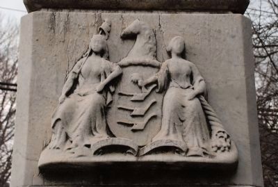
On Stockton Street at Rogers Ave. on Stockton Street.
To the memory of the heroic volunteers of East Windsor Township who gave their lives as a sacrifice for their country and humanity in the suppression of the Great Rebellion of 1861-65. — — Map (db m5431) HM
Henry Phillips was a third generation Phillips family member in Pleasant Valley; his grandfather arrived in 1737. Ca, 1805, Henry constructed the stone section of the house on the land he inherited from his father. Ca, 1830, he added the large frame . . . — — Map (db m94714) HM
On South Clinton Avenue at Stevens Alley, on the right when traveling south on South Clinton Avenue.
Mercer Cemetery, the first non-sectarian cemetery in New Jersey, is designated as a Trenton City Landmark. Organized in 1843, the cemetery was once the preferred final resting place for many of Trenton's prominent families.
The cemetery . . . — — Map (db m208120) HM
Near Province Line Road 0.5 miles north of Ettl Circle, on the left when traveling north.
Two centuries ago this was a remote spot. Stony Brook flowed swiftly down the narrow, winding, wooded valley. There was no bridge, no mill and no indication in the landscape that this was where the Province Line had been surveyed through the . . . — — Map (db m305652) HM
On Princeton Pike (County Route 583) at Lenox Drive, on the right when traveling south on Princeton Pike.
No one knows for sure the age of the Brearley Oak. With a trunk circumference of 258 inches, a height of 110 feet, and a crown of 148 feet (as measured in 2019), estimates of its age are anywhere from 255 to 410 years old. This magnificent tree is . . . — — Map (db m303418) HM
Near Paxson Avenue 1 mile east of Hughes Drive, on the right when traveling west.
Welcome to the Rogers Farmstead. You are standing on the edge of the barnyard to the rear of the farmhouse. Conjure up the sounds and smells and daily routines of the farming life as the Rogers family labors here raising crops and livestock, . . . — — Map (db m297533) HM
Trenton has been a seat of county and municipal government since colonial times, although the impact of government on the landscape of the city was relatively limited until the early 20th century. Prior to 1900, most government business was . . . — — Map (db m166110) HM
On West K Street, on the right when traveling west.
On this site was organized by the Rev. Sylvester Woodbridge, Jr., on April 15, 1849 the First Presbyterian Church of Benicia. This was the first protestant church established in California with an ordained resident pastor. The church of disbanded in . . . — — Map (db m95697) HM
On Lewisville Road 0.7 miles east of Franklin Corner Road (County Route 546), on the right when traveling east.
Ranged along this stretch of roadway is the small village of Lewisville, Lawrence Township's earliest African American community, founded by former enslaved persons and their descendants from Lawrence and the surrounding townships. They began . . . — — Map (db m303279) HM
On Bergen Street just south of Stonerise Drive, on the right when traveling south.
The background story to the road in front of you, today known as Bergen Street, is part of our region’s ongoing love-hate relationship with highways. Believe it or not, Bergen Street was planned during the late 1920s as part of Arctic Highway, a . . . — — Map (db m303557) HM
This wall encloses a portion of a plot of two acres whereon was erected in 1704 the first Christian church within the present confines of Mercer County.
Early records refer to it as “Hopewell Church” and “Christ Church”.
It was built . . . — — Map (db m4073) HM
Born 1807, in Trenton.
He was the editor of the New Jersey State Gazette early in his career. Later a member and president of the Common Council, he served the short term as mayor of Trenton – April 6 to 9, 1855 – filling the vacated seat of . . . — — Map (db m4542) HM
On Lamberton Street at Lalor Street, on the left when traveling north on Lamberton Street.
Gifted to the City of Trenton and the Mercer County Parks Commission
by the New Jersey Department of Transportation
and the successful efforts of the Route 29 Community Partnering Team.
Designer: Vollmer Associates, LLP
Contractor: PKF-Mark . . . — — Map (db m4451) HM
On the occasion of James W. Marshall's 200th birthday, the Native Sons of the Golden West rededicate this monument erected in his honor. Born in Hopewell Township, Mercer County, New Jersey to Phillip and Sarah Wilson Marshall on October 8, 1810, he . . . — — Map (db m71528) HM
On Mercer Street 0.5 miles north of Parkside Drive, on the right when traveling north.
The Mercer Oak was named for Brigadier General Hugh Mercer, who fought and was mortally wounded in the Battle of Princeton, January 3, 1777. The white oak is believed to have been here at the time of the American Revolution.
A legend says that . . . — — Map (db m166095) HM
The Sanhickans were a band of the Algonquian-speaking Lenape that occupied the Middle Delaware valley at the time of European contact in the 17th century. The Lenape territory ranged from the Atlantic coastline inland up into the Delaware, . . . — — Map (db m166140) HM
On Pennington Rocky Hill Road (County Route 624) 0.1 miles south of Old Mill Road, on the right when traveling south.
Here, in the heart of Hopewell's Stony Brook valley, the soils are deep and fertile, perfect for raising crops and livestock. Following the displacement of the Native American Lenape people living here around the turn of the 18th century, European . . . — — Map (db m307732) HM
On Pennington Rocky Hill Road just north of Bailey Drive, on the right when traveling north.
This brick building and its associated archaeological site were entered into the National Register of Historic Places in 1996. The township acquired the property in 1998 through a land gift from Toll Brothers, the developer of nearby Hopewell . . . — — Map (db m305860) HM
(On the Rededication Marker):
Restored and rededicated by the people of New Jersey in honor of all those from this state who served with courage, dignity, and patriotism in the armed forces of the United States of America
Our land is . . . — — Map (db m239833) WM
On Scotch Road at Washington Crossing Pennington Road, on the left when traveling north on Scotch Road.
30 Years A Neighborhood Classroom
Rural Hopewell Township at the turn of the 20th century boasted as many as 14 separate school districts. From 1907 until 1936 the one-room Hart's Corner Schoolhouse served students of Bear District No. 12. . . . — — Map (db m312544) HM
On Pennington Rocky Hill Road (County Route 624) at Elm Ridge Road (County Route 625), on the right when traveling south on Pennington Rocky Hill Road.
The impressive range of white frame farm buildings before you – the immense barn and silo complex to the left; the wagon houses and corn crib in the center; and the spacious farmhouse at the right – evoke Hopewell farming at its most prosperous . . . — — Map (db m305711) HM
On Assessment Road west of ETS Drive, on the left when traveling south.
The story of the corporate campus around you, headquarters educational testing organization in the world, began on a crisp autumn day in 1954. Henry Chauncey, the first president of ETS, was taking a hike with his wife Laurie. After exiting the . . . — — Map (db m305642) HM
On Province Line Road at Audubon Lane, on the right when traveling south on Province Line Road.
As you hike or bike the LHT alongside Province Line Road, you are following in the footsteps of Surveyor-General George Keith. For two months in the spring of 1687, Keith surveyed a line through the wilderness of colonial New Jersey in an attempt . . . — — Map (db m305618) HM
Three centuries ago, the landscape before you would have appeared much different. Looking west toward today's State House, you would have been facing a steep-sided ravine with wooded slopes and a fast flowing stream passing from right to left to . . . — — Map (db m76805) HM
On Delaware and Raritan Canal State Park Trail 0.1 miles south of Interstate 295, on the left when traveling south.
The I-295 Scenic Overlook is an excellent place from which to set off exploring the marshland's ecology and history.
It is a short walk from the northbound parking lot to the Delaware & Raritan Canal State Park Towpath Trail. The . . . — — Map (db m270760) HM
On Paxson Avenue 1.6 miles east of Hughes Drive when traveling east.
The stabilized farmhouse ruin before you is an example of a type of patterned brick dwelling that was built in the late 17th and 18th centuries throughout the coastal plain in the Delaware Valley and Chesapeake regions. This is one of the most . . . — — Map (db m297630) HM
Near Southfield Road 0.5 miles north of New Village Road, on the right when traveling north.
Centuries of slavery destroyed countless people and families - dehumanized, abused, and sold as property. Its profound impacts have persisted for generations. West Windsor, a farming town from colonial settlement until the late 20th century, wasn’t . . . — — Map (db m302378) HM
(Front):
Mercer County to her sons
who served in the United States
Army and Navy
1861-1866.
Dedicated June 19, 1909
(Soldier’s Side):
Liberty and Union
One Flag
One Land
One Nation Evermore
. . . — — Map (db m187326) HM
Thin black lines indicate changes in relevance. Between each pair of lines entries are ordered geographically but all have the same relevance.
* Inflectional forms of words are their plurals, singulars, and possessives as well as gramatical tenses and similar variations.