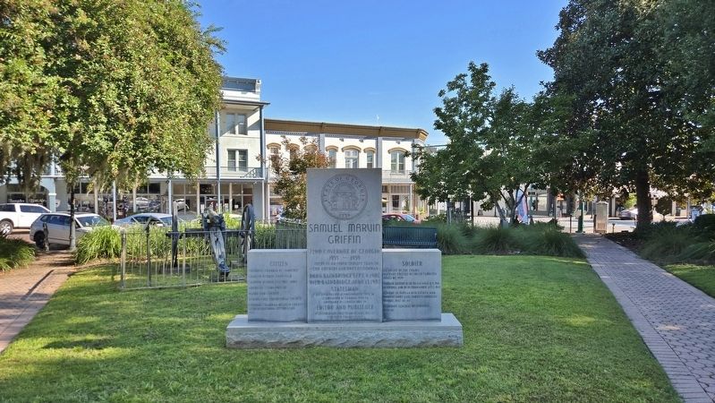
Near East Water Street just east of North West Street, on the right when traveling east.
[center panel]72nd Governor of Georgia 1955-1959 There is no finer service than to God, country and one’s fellowman Born Bainbridge Sept. 4, 1907 Died Bainbridge June 13, 1982 Statesman Decatur County representative . . . — — Map (db m258079) HM
Near West Jackson Street west of North Florida Street, on the right when traveling west.
Decatur County was once a frontier region shared by the Creek and the Seminole Nations. The Creeks, comprised of dozens of loosely associate groups, lived primarily along the southern reaches of the Chattahoochee and Flint Rivers in Alabama and . . . — — Map (db m117156) HM
On Booster Club Road 0.9 miles west of Hutchinson Ferry Road (Georgia Highway 97 Spur), on the left when traveling west.
This medical camp was established on September 15, 1820 by the Southeastern Army of the United States headquartered at Fort Scott. It was used as a recuperation area for soldiers who had contracted malaria and dysentery in the swampy environs of the . . . — — Map (db m55884) HM
Near West Jackson Street west of North Florida Street, on the right when traveling west.
The area that became Decatur County played a major role in the First Seminole War. Located on the border with Spanish Florida, the region witnessed persistent violence and raiding between American settlers, Creeks and Seminoles in the early . . . — — Map (db m117154) HM
Near West Jackson Street west of North Florida Street, on the right when traveling west.
The Battle of Fowltown, fought just a few miles to the south of this spot, marked the beginning of the First Seminole War. Fowltown was a Seminole village led by Chief Neamathla which had been allied with the British during the War of 1812. It lay . . . — — Map (db m117158) HM
Near West Jackson Street west of North Florida Street, on the right when traveling west.
Conflict between Creeks, Seminoles and Americans continued in the years after the First Seminole War. Beginning in the 1820s in Florida, the United States pressured the Seminoles to relocate to the West. At the same time in Georgia and Alabama, the . . . — — Map (db m117160) HM
On Dothan Road (U.S. 84) at Yates Spring Road (Georgia Route 310), on the right when traveling east on Dothan Road.
Brinson
First settled in the 1850’s present day Brinson was originally known as Spring Creek. The name was changed in 1889 when the town was laid out and established by Simeon Brinson. In that same year the Alabama Midland Railroad . . . — — Map (db m55981) HM
Near West Jackson Street at North Florida Street, on the right when traveling west.
Since the 1700s, Bainbridge has been home to Creek, Seminole, and American citizens. Historical events such as wars, treaties, and forced removal have shaped the movement of people to and from Bainbridge. 1700s-1814 Decatur County . . . — — Map (db m258190) HM
On East Water Street just east of North West Street, on the right when traveling east.
1906 Unveiling Source: The Bainbridge Post Search Light, April 27, 1906 Thursday, April 26, 1906, the people of Bainbridge and Decatur County, under the leadership of the Daughters of the Confederacy, gathered . . . — — Map (db m257859) HM
On Braswell Godby Road (County Route 12) at Church Street, on the right when traveling north on Braswell Godby Road.
Side 1: Site of U.S. Post Office Reynoldsville, Georgia
On this site was situated the Reynoldsville Post Office from April 5, 1898 to April 20, 1913. The community was named by the Post Office Department in honor of Reuben Arthur . . . — — Map (db m55677) HM
On West Jackson Street 0 miles west of North Florida Street, on the right when traveling west.
This monument was originally located in Land Lot Number 224 in the 21st District of Decatur County, Georgia, 16 miles southwest of Bainbridge and on the site of Fort Scott built in 1816 and abandoned in 1821.
It was removed to its present . . . — — Map (db m55902) HM
Near North Clark Street just south of East Broughton Street, on the left when traveling north.
Taking the oath of office on January 4, 1978, Luther H. Conyers, Jr. served as a member of the Bainbridge City Council for 37 years. At the time of his retirement in December 2015, he was the longest serving councilman in the city's history. In . . . — — Map (db m258173) HM
On East Griffin Avenue (Business U.S. 27) at North Main Street, on the right when traveling west on East Griffin Avenue.
Attapulgus was one of the first settlements in Decatur County, Georgia. It was first known as the Borough of Pleasant Grove. The name was changed when a post office was established in 1838. “Attapulgus” was taken from a Creek Indian . . . — — Map (db m40944) HM
On Tallahassee Highway (U.S. 27) 0 miles north of Amsterdam Road, on the right when traveling north.
In 1926, brothers John, Earl, Wayne and Gilbert Gragg came from North Carolina to establish a sawmill six tenths of a mile north of here on the east side of Amsterdam Road. As the Gragg Lumber Co., they leased cutting rights on 16,000 acres . . . — — Map (db m56071) HM
On Englehard Way at Clay Street, on the right when traveling east on Englehard Way.
Attapulgite
There are many types of Fullers Earth clay. Attapulgite is a unique type, found in the USA only in Decatur County, GA and Gadsden County, Fl. It is also found in Spain, Russia , and China. The unique nature of Attapulgite is, . . . — — Map (db m40870) HM