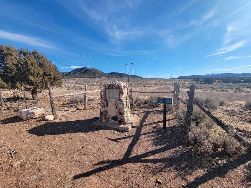
Jefferson Hunt
This site marks one of the most controversial events in the history of 1849. Here, a large group deserted wagon train leader, Jefferson Hunt, and headed west toward present day Enterprise, Utah. Their subsequent trek is part . . . — — Map (db m239744) HM
This building, erected in 1866, served the community of Parowan for 52 years as a religious and cultural center. Later it was given by the L.D.S. Church to the Daughters of Utah Pioneers, who in 1939-40 restored the old edifice and in 1949-50 . . . — — Map (db m59614) HM
On Main Street at 100 South, on the right when traveling north on Main Street.
"I commenced a grammar school in my wickiup by the light of the fire and only one grammar book." Diary of George A. Smith, February 25, 1851.
The first school house, 18 x 24 feet, was built west of the Council House and dedicated December 25, . . . — — Map (db m59611) HM
On Center Street at 200 West, on the left when traveling west on Center Street.
The Parowan Dramatic Association was organized in 1851 with Edward Dalton president, Jessie V. Smith, Joseph, Jane and Annie Fish, David and Wm. Cluff, Wm. C. McGregor and Ed Ward, members. Plays were produced in Log Council House and Rock Church . . . — — Map (db m59615) HM
On South Main Street 0.1 miles south of Center Street, on the right when traveling south.
This church built of sandstone brought from Parowan Canyon, started in 1863 and completed about 1876, was the religious center of Parowan Valley. The large amusement hall in the basement was used for school and dances. A stage was erected in the . . . — — Map (db m59613) HM
On East 200 South at North 100 East, on the left when traveling east on East 200 South.
At Parowan, a pioneer industrial center was settled in 1851. Water for manufacturing and industry was carried by wooden flume from the canyon to the fort. Along this water line industries were established known as the Public Works. Among these were . . . — — Map (db m59574) HM
On South Main Street, on the right when traveling north.
Constructed c. 1895, the William and Julia Lyman House is a type known as a central passage, where a central hallway divides the two equally sized main-floor rooms. The Lyman House is one of only a few of this type remaining in Parowan. The central . . . — — Map (db m59600) HM
On Upper Bear Valley Road west of Utah Road 20, on the right when traveling west.
...the longest, crookedost, most arduous pack mule route in the history of America...
Profit could be made transporting New Mexico serapes and other woolen goods to Los Angeles, and wrangling California-bred horses and mules back to . . . — — Map (db m272575) HM
Exploring the Old Spanish Trail in Iron County, UT
Spanish Explorers traveled nearly 100 miles through Iron County on routes that are known today as major highways. Travel on our modern day roads to get a glimpse into the past.
Enoch . . . — — Map (db m266934) HM
On West Old US Highway 91, on the right when traveling south.
...the longest, crookedost, most arduous pack mule route in the history of America...
Profit could be made transporting New Mexico serapes and other woolen goods to Los Angeles, and wrangling California-bred horses and mules back to . . . — — Map (db m274178) HM
...the longest, crookedost, most arduous pack mule route in the history of America...
Profit could be made transporting New Mexico serapes and other woolen goods to Los Angeles, and wrangling California-bred horses and mules back to . . . — — Map (db m274179) HM
On Old US Highway 91, on the left when traveling south.
...the longest, crookedost, most arduous pack mule route in the history of America...
Profit could be made transporting New Mexico serapes and other woolen goods to Los Angeles, and wrangling California-bred horses and mules back to . . . — — Map (db m274175) HM
On West Center Street at North 2nd Street West, on the right when traveling west on West Center Street.
Born December 2, 1834 in Stockholm, New York, son of Silas and Mary Aikens Smith, and first cousin to the Prophet Joseph Smith, he crossed the great plains to the Salt Lake Valley in 1847 with the Mormon pioneers. Called to help colonize Parowan in . . . — — Map (db m36736) HM
This is the oldest log cabin in Southern Utah. It was built in 1851 in Parowan by George Wood, one of the founders of Iron County, who later moved it to the Old Fort in Cedar City and then to his lot on North Main Street. Through the years it was . . . — — Map (db m239742) HM
On North Main Street (Utah Route 130) south of West 65 North Street (West Harding Avenue), on the right when traveling south.
Born in Springshire, England, and an iron-molder by trade, Richard Harrison served as superintendent of the world’s largest iron foundry, located in Liverpool. He immigrated to Nauvoo, Illinois, in 1843 then on to Utah in 1849. He arrived in Cedar . . . — — Map (db m130595) HM
Led by Captains John T. Baker and Alexander Fancher, a California-bound wagon train from Arkansas camped in this valley in the late summer of 1857 during the time of the so-called Utah War. In the early morning hours of September 7th, a party of . . . — — Map (db m46765) HM
On Utah Route 144 4 miles west of Interstate 15, on the right when traveling west.
Fort Harmony was designated as the training site of the Iron County division of the Utah Militia. In 1857 the Militia was divided into 13 districts. The southern group consisted of all counties south of Beaver and was known as the Iron County . . . — — Map (db m75622) HM
On North Main Street (Utah Route 130) south of Iron Mission Parkway (West 685 North), on the right when traveling south.
Iron County exists because those who lived here developed the resources necessary for survival in this desert climate. The three legacies passed down by early settlers and their descendants — agriculture, mining, and railroads — are . . . — — Map (db m130593) HM
On North Main Street (Utah Route 130) south of Iron Mission Parkway (West 685 North), on the right when traveling south.
In the 1930s, iron mining expanded in Iron County and massive shovels were needed to excavate the needed ore. According to company delivery records, two Bucyrus-Erie 120-B shovels were delivered to the Utah Construction Company in Cedar City in . . . — — Map (db m130598) HM
On West Gap Road, on the right when traveling west.
Southern Utah Expedition of 1849
Realizing the limited resources for pioneer settlement in the Salt Lake Valley and surrounding settlements in 1849, and the potential of many more immigrants arriving in the next few years, Brigham Young . . . — — Map (db m274198) HM
On this site, in 1876, the Cedar Co-operative Mercantile and Manufacturing Institution constructed the Cedar Co-op Mill. It was a large, three-story wooden building. The original two sets of four foot grinding stones were turned by water which was . . . — — Map (db m266831) HM
On West 100 South Street west of South Main Street, on the right when traveling west.
There are three markers on this kioskCenter Marker
The Ute Domain
First described by Spanish explorers as the YUTA Indians (pronounced Ute-ah), the ancestors of the Ute people are thought to have migrated from the . . . — — Map (db m75470) HM
On W 200 S (State Road 143) at S 100 W, on the right when traveling west on W 200 S.
In 1850, discovery of large deposits of iron ore and coal in this vicinity by Parley P. Pratt, a Mormon leader and explorer, led Brigham Young to plan immediate colonization and development of the entire Southern Utah area.
Parowan was . . . — — Map (db m272547) HM
The first wagon over the Old Spanish Trail came into Iron County, Utah, May 15, 1848, with
25 Mormon Battalion men returning from California under Captain Henry G. Boyle. Piloted by
Porter Rockwell & James Shaw, they converted the western half of . . . — — Map (db m256021) HM
The disappearance of a Western Air Services Boeing 95 mail plane during an intense snow storm thrust Cedar City, Utah, into the sharp focus of world attention. It was not because such accidents were uncommon, for air crashes were quite common in . . . — — Map (db m74002) HM
Thin black lines indicate changes in relevance. Between each pair of lines entries are ordered geographically but all have the same relevance.
* Inflectional forms of words are their plurals, singulars, and possessives as well as gramatical tenses and similar variations.