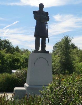
On Municipal Center Drive 0.1 miles west of South Campbell Station Road, on the left when traveling west.
Admiral David Glasgow Farragut
Birthplace - Campbell Station in Knox County, Tennessee
* James Glasgow Farragut was born on 5 July 1801 in a log cabin at Stony Point just four miles southeast of the location referred to in 1801 as . . . — — Map (db m69466) HM
On Daniel Boone Drive (State Highway 11) at Cumberland Avenue (State Highway 2421), on the right when traveling west on Daniel Boone Drive.
(First Panel): Building Union Support Tennessee Unionists Revolt Tennessee seceded from the Union in June 1861. Most people in Middle and West Tennessee supported that action but a large number of East Tennesseans did no. East Tennesseans . . . — — Map (db m35830) HM
On Kingston Pike (U.S. 11) at Lendon Welch Way, on the right when traveling west on Kingston Pike.
A native of Stony Point (Low's Ferry) David Farragut moved to New Orleans at the age of three. At the age of ten, he began a career with the U.S. Navy; ca. 1827, pioneered a school for seamen; 1841, improved hoisting machinery for ammunition; . . . — — Map (db m261481) HM
Near Main Street Southwest at South Gay Street, on the right when traveling east.
Died in Russellville, Ala. October 7, 1836
(south side)Historical Katherine Sherrill Sevier, Bonny Kate, came when a girl with her parents, to Tennessee from North Carolina; married John Sevier August 14, 1780 when she was 26 years . . . — — Map (db m134862) HM
In spring, dogwood blossoms grace a countryside laden with marble. Within Knox County, named for Secretary of War Henry Knox, the Holston and a French Broad rivers converge, forming the Tennessee River. This fortunate geography shaped an industrial . . . — — Map (db m201297) HM
Near North Broadway (U.S. 441) south of Tyson Street, on the right when traveling south.
In loving memory of
Mary Boyce Temple
1856 — 1929
Daughter of Judge and Mrs O P Temple
Organizing Regent Bonny Kate Chapter
Oct. 7, 1893
Vice president General N.S.D.A.R. 1898-9
State Regent of Tennessee, 1906-7 1920-21
Honorary . . . — — Map (db m195489) HM
On U.S. 231 0.2 miles north of State Route 36, on the right when traveling north.
Abundant water and fertile land in this area south of the Tennessee River attracted pioneer settlement in the early 1800s. The community established here by three Virginia-born brothers, Hopkins, John, and Theophilus Lacy, took on their name and . . . — — Map (db m27611) HM
Near Main Street Southwest at South Gay Street, on the right when traveling east.
John Sevier, ”Nolichucky Jack,” Sept. 23, 1744, Sept. 24, 1815.
Pioneer, Soldier, Statesman and one of the founders of the Republic.
(west side) The typical pioneer who conquered the wilderness and fashioned the State. . . . — — Map (db m134861) HM WM
By 1887, Concord was the second largest community in Knox County, second to Knoxville. The Village of Concord was a regional transportation center. Tennessee marble, crushed limestone, lime, logs and farm produce were gathered at its public dock. . . . — — Map (db m101433) HM
On Daniel Boone Drive (State Highway 11) at Cumberland Avenue (State Highway 2421), on the right when traveling west on Daniel Boone Drive.
(First Panel): Camp Andy Johnson Established August 1861 Camp Andy Johnson was named for Senator Andrew Johnson of Greenville, Tennessee, the only senator from a seceding state who remained loyal. The camp was a refuge for the loyal men . . . — — Map (db m294355) HM
In 1902, eight men from the community met to consider the question of establishing a high school in the 10th district of Knox County. Mr. C.H. Stoltzfus, a farmer in the community, was elected president of this group. Mass meetings for all members . . . — — Map (db m100881) HM
On Fort Dickerson Road Southwest west of Chapman Highway SW, on the left when traveling north.
What Brought the Armies of the Blue and the Gray to Knoxville?
Knoxville was a pro-Confederate town of some 3700 persons when Tennessee seceded from the Union in June of 1861. It was the commercial and light manufacturing center of East . . . — — Map (db m82201) HM
On South Gay Street at West Church Avenue, on the left when traveling north on South Gay Street.
Born in northern Knox County (now part of Union County), Lloyd Branson is regarded perhaps as Knoxville's finest professional artist. Branson's family moved to Knoxville in 1868, and exhibited extraordinary talent as a youngster. After studying at . . . — — Map (db m134898) HM
Near Natchez Trace Parkway (at milepost 293.2), 0.3 miles west of John Rankin Highway (County Road 1).
In the mid 1700's Sieur de Bienville, founder of Mobile, recommended to Louis XIV, a waterway connecting the Tennessee River with the Tombigbee River. Later, American settlers also recognized the advantages of such a shortcut. Residents of Knox . . . — — Map (db m84730) HM
On West Central Avenue at First Street North, on the left when traveling east on West Central Avenue.
A keeper of the African American string-band tradition, Howard Armstrong was a multi-instrumentalist with a very extensive repertoire. He was also a multilinguist, painter, and teller of folk tales and anecdotes drawn from his long life and career. . . . — — Map (db m233100) HM
Union County is a testament to the strong support for the Union in East Tennessee prior to the Civil War. It’s picturesque expanse was formed from portions of Anderson, Campbell, Claiborne, Grainger, and Knox counties. Attorney Horace Maynard, for . . . — — Map (db m201296) HM
On Byington Beaver Ridge Road (Tennessee Route 131), on the left when traveling north.
Born circa 1862 in McMinn County, Tennessee, Moses Brownlow Byington Sr., moved to the Beaver Ridge community circa 1883. He was instrumental in establishing the town of Byington and two major landmarks: the Byington L & N Railroad Station around . . . — — Map (db m114040) HM
Near North Broadway (U.S. 441) at Emory Place, on the right when traveling south.
Since the Civil War, the thirteen-acre Old Gray Cemetery has been the final resting place for Union and Confederate
veterans. During the conflict, control of Knoxville shifted from Confederate to Union forces, so it is appropriate that both sides . . . — — Map (db m82211) HM
On W Main St east of Walnut St, on the right when traveling east.
The third courthouse of Knox County was across Main Ave. to the north from 1842-1886. There twelve Union raiders who were charged with train stealing in the 1862 Great Locomotive Chase in Georgia, were tried in 1863. One was convicted. The trial was . . . — — Map (db m4106) HM
On East Magnolia Avenue (U.S. 70) at Winona Street, on the left when traveling west on East Magnolia Avenue.
Untitled Abstract, 1960
Beck Cultural Exchange Center Collection
Born in Knoxville, Ruth Cobb Brice graduated from Swift Memorial College, a historically Black college in Rogersville, and was soon teaching at schools in Rogersville, . . . — — Map (db m178107) HM
On East Magnolia Avenue (U.S. 70) at North Bertrand Street, on the left when traveling west on East Magnolia Avenue.
Untitled Abstract, 1960
Beck Cultural Exchange Center Collection
Born in Knoxville, Ruth Cobb Brice graduated from Swift Memorial College, a historically Black college in Rogersville, and was soon teaching at schools in Rogersville, . . . — — Map (db m178110) HM
On East Hill Avenue at James White Parkway, on the left when traveling north on East Hill Avenue.
Abstract Landscape with Birds, 1965
Born in Knoxville, Ruth Cobb Brice graduated from Swift Memorial College, a historically Black college in Rogersville, and was soon teaching at schools in Rogersville, Greeneville, and LaFollette. . . . — — Map (db m223857) HM
On West Church Avenue at Locust Street, on the right when traveling east on West Church Avenue.
Lawson McGhee Library (west panel) ”I intend to erect a building to be used as a public library, and at the same time, a memorial to a beloved child.” -Charles McClung McGhee
The original Lawson McGhee Library was the first . . . — — Map (db m134882) HM
On South Gay Street south of Clinch Ave, on the left when traveling north.
Roger Hoffman Howell was raised in Pittsburgh, Pennsylvania. In the mid-1930s, he came to Knoxville, Tennessee, to work as an engineering draftsman for the newly commissioned Tennessee Valley Authority.
Howell's personality can be seen in . . . — — Map (db m263602) HM
On Henley Street at Cumberland Avenue, on the left when traveling north on Henley Street.
East Tennessee Female Institute, circa 1828 (painted 1960)
Oil on Canvas, 16 x 20 inches
Ossoli Circle Collection
Russell Briscoe was an unlikely artist. Raised in the Fort Sanders neighborhood, he
enjoyed an idyllic childhood in a . . . — — Map (db m221817) HM
On North Broadway (U.S. 441) at North Central Street, on the right when traveling south on North Broadway.
Morning Milking Time, circa 1915
Oil on Canvas, 46 x 36 ¼ inches
Knoxville Museum of Art, 2012 joint purchase of the Calvin M. McClung Historical Collection, Knox County Public Library, and the KMA with funds provided by the C. M. . . . — — Map (db m223854) HM
On Chapman Highway (Tennessee Route 441), on the right when traveling north.
Knox County Established 1792; named in honor of Maj. Gen. Henry Knox Washington's Chief of Artillery in the Revolutionary War. Secretary of War in Washington's Cabinet. One of the founders and first Secretery of the Society of Cincinnati.Sevier . . . — — Map (db m100507) HM
Near Municipal Center Drive at South Campbell Station Road, on the left when traveling west.
David Glasgow Farragut (July, 5 1801-August 14, 1870), a flag officer of the United States Navy during the American Civil War, became the first rear admiral, vice admiral, and admiral of the United States Navy. He is remembered in popular culture . . . — — Map (db m261254) HM
On Hall of Fame Drive at Historic Preservation Way, on the left when traveling south on Hall of Fame Drive.
Untitled, 1970
Born in Knoxville, Ruth Cobb Brice graduated from Swift Memorial College, a historically Black college in Rogersville, and was soon teaching at schools in Rogersville, Greeneville, and La Follette. During the summer months . . . — — Map (db m222648) HM
David Campbell, who owned much of the land in the fertile region called Grassy Valley, donated a portion of it for the purpose of erecting a "Meeting House", as churches were then called. A school building at the location was about one and one . . . — — Map (db m100834) HM
History tells us that as early as 1785, the State of Franklin (today Tennessee) entered into an agreement, known as the Dumplin Creek Treaty, with the Cherokees. This treaty opened the land along the French Broad and Holston rivers to a rush of . . . — — Map (db m107928) HM
In May 1979, a group of citizens began meeting to discuss the possibility of incorporation. They felt incorporation was necessary in order to control zoning, land use, signage issues and Farragut's own destiny. A small steering committee, named the . . . — — Map (db m101750) HM
On Walnut Street (U.S. 90), on the right when traveling east.
William L. Menefee, born ca. 1796 in Knox County, Tennessee, served in the Tennessee Militia in the War of 1812. He studied law and was admitted to the bar sometime prior to 1824 when he moved to Alabama. In 1830 he and his wife Agnes (Sutherland) . . . — — Map (db m130391) HM
On West Hill Avenue at State Street, on the right when traveling west on West Hill Avenue.
Chisholm's Tavern was the name of a tavern (more defined as an Inn) in the 1790s located near the site of the Dwight Kessel Garage. The tavern was established by John Chisholm, an early settler important to the development of Knoxville. Chisholm was . . . — — Map (db m118582) HM
On Kodak Road at Deaton Hollow Road, on the left when traveling east on Kodak Road.
1797 – Manifold Station – 1820
Here at the mill and trading post
of Benjamin Manifold, Jr., many a
weary traveler westward bound
found provision, safety and hope. — — Map (db m195432) HM
Near South Northshore Drive (Tennessee Route 332) at Maple Seed Road, on the right when traveling east.
In front of you, on the promontory just across the cove, is where David Glasgow Farragut was born on July 5, 1801. Farragut's father, George Farragut, came to the American colonies in 1776 from Spain as a merchant sea captain. During the . . . — — Map (db m101431) HM
On Main Street (U.S. 36) at Clayton Street, on the right when traveling west on Main Street.
A descendent of Knox County’s earliest pioneers, Confederate Brigadier General Daniel Harris Reynolds was born just three miles west of Centerburg in 1832. He attended Ohio Wesleyan University in Delaware, where he became a close friend of Otho . . . — — Map (db m59460) HM
On Old Highway 46 (County Highway 952) 0.2 miles north of Old Bon Aqua Road, on the right when traveling north.
(side 1)
Major Philip Van Horn Weems, CSA
Born Nov. 6. 1837, Philip Van Horn Weems owned this property known as Weems's Springs prior to the Civil War. In May 1861, he enlisted in the Hickman Guards, later Co. H, 11th Regt. TN, . . . — — Map (db m155770) HM
On Old Knoxville Highway (Tennessee Route 33), on the right when traveling north.
Knox County
Established 1792; named in honor of
Maj. Gen. Henry Knox
Washington's Chief of Artillery in the Revolutionary War. Secretary of War in Washington's Cabinet. One of the founders and first secretary of the Society of the . . . — — Map (db m109332) HM
On Loves Creek 0.1 miles north of McIntyre Road, on the right when traveling north.
Alfred Buffat (1840-1908) came to Knox County at the age of 10 with his parents from Switzerland in search of religious tolerance and economic opportunity.
In 1851, the water milling enterprise was started to supplement the Buffat family's farm . . . — — Map (db m195475) HM
Alice Yoe Ijams was born in Jefferson City, Tennessee on August 20, 1880. Alice grew up in Knoxville and married H.P. Ijams in 1905. In her day, Alice was a leading horticulturalist, expert flower arranger, and a renowned "walking encyclopedia of . . . — — Map (db m256278) HM
Thin black lines indicate changes in relevance. Between each pair of lines entries are ordered geographically but all have the same relevance.
* Inflectional forms of words are their plurals, singulars, and possessives as well as gramatical tenses and similar variations.