THE HISTORICAL
MARKER DATABASE
“Bite-Size Bits of Local, National, and Global History”


59 entries match your criteria.  


Entries Containing All of the Phrases «cumberland county» AND «virginia»

This list will also include matches for inflectional* forms of the words.
 
By Bernard Fisher, July 25, 2009
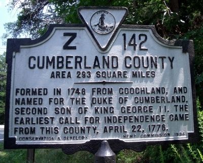
Cumberland County Marker
RANKED BY RELEVANCE
1 ► Virginia, Buckingham County, Cumberland — Z-142 — Buckingham County / Cumberland County —
On Anderson Highway (U.S. 60) 0.4 miles west of Ayers Road, on the left when traveling west.
2 ► Virginia, Powhatan County, Powhatan — Z-50 — Cumberland County / Powhatan County —
On Old Buckingham Road 0.3 miles west of Evans Road, on the right when traveling west.

3 ► Virginia, New Kent County, Providence Forge — W-21 — State Game Farm —
On Pocahontas Trail (U.S. 60) at GW King Boulevard, on the right when traveling east on Pocahontas Trail.

4 ► Virginia, Cumberland County, Cartersville — 7 — Rosenwald School at Cartersville — Cartersville, Virginia — Civil Rights in Education Heritage Trail® —
Near Cartersville Road (Virginia Route 45) 0.1 miles north of Ampthill Road, on the right when traveling north.
5 ► Virginia, Cumberland County, Cumberland — 8 — Jackson Davis — Cumberland Court House, Virginia — Civil Rights in Education Heritage Trail®
On Foster Road at Anderson Highway (U.S. 60), on the left when traveling north on Foster Road. Reported permanently removed.

6 ► State Historical Markers Numbering Plans
7 ► Virginia, Cumberland County, Cartersville — Clifton —
On Columbia Road at Boston Hill Road, on the right when traveling west on Columbia Road.

8 ► Illinois, Cumberland County, Greenup — "The Road that Built the Nation" —
On Cumberland Road north of U.S. 40, on the right when traveling east.

9 ► Virginia, Nottoway County, Crewe — Peter Francisco: Hercules of the Revolution —
On West Virginia Avenue (U.S. 460) just east of Lee Street (County Road T-1031), on the right when traveling east.

10 ► Virginia, Amelia County, Amelia Court House — 9 — Russell Grove Presbyterian Church and School — Amelia Court House, Virginia — Civil Rights in Education Heritage Trail®
On Otterburn Road (Virginia Route 614) 0.1 miles south of Leidig Street ( Route 634), on the left when traveling south. Reported permanently removed.
11 ► Virginia, Brunswick County, Alberta — 38 — Southside Virginia Community College — Alberta, Virginia — Brunswick County
Near Campus Drive (County Route 378) near Chritanna Highway ( Route 46). Reported permanently removed.
12 ► Virginia, Brunswick County, Lawrenceville — 41 — Fort Christanna — Lawrenceville, Virginia — Brunswick County
On Fort Hill Road 1.1 miles west of Christanna Highway ( Route 46), on the right when traveling west. Reported permanently removed.
13 ► Virginia, Brunswick County, Lawrenceville — 39 — Saint Paul's College — Lawrenceville, Virginia — Brunswick County
On College Drive 0.1 miles north of Windsor Avenue ( Route 46), on the right when traveling north. Reported permanently removed.
14 ► Virginia, Buckingham County, Buckingham — 4 — One-Room Schoolhouse — Buckingham, Virginia — Buckingham County
Near Lee Wayside Road near Anderson Highway (U.S. 60). Reported permanently removed.
15 ► Virginia, Buckingham County, New Canton — 5 — Carter G. Woodson Birthplace — New Canton, Virginia — Buckingham County
On C G Woodson Road (Virginia Route 670) 0.2 miles north of Liberty Road ( Route 759), on the right when traveling north. Reported permanently removed.
Paid Advertisement
16 ► Virginia, Charlotte County, Charlotte Court House — 30 — Charlotte County Library
On Legrande Avenue (Virginia Route 47) at David Bruce Avenue ( Route 40) on Legrande Avenue. Reported permanently removed.
17 ► Virginia, Charlotte County, Keysville — 29 — Southside Virginia Community College — Keysville, Virginia — Charlotte County
On Tech Lane at Lunenburg Highway ( Route 40) on Tech Lane. Reported permanently removed.
18 ► Virginia, Charlotte County, Red Oak — 31 — Salem School — Red Oak, Virginia — Charlotte County
On Cargills Creek Road (County Route 632) at Salem School Road (County Route 608), on the right when traveling west on Cargills Creek Road. Reported permanently removed.
19 ► Virginia, Chesterfield County, Ettrick — 11 — Virginia State University — Ettrick, Virginia — Chesterfield County
On Matthews Jefferson Drive at East River Road, on the right when traveling south on Matthews Jefferson Drive. Reported permanently removed.
20 ► Virginia, Cumberland County, Cartersville — 6 — Hamilton High School — Cartersville, Virginia — Civil Rights in Education Heritage Trail —
Near Cartersville Road (Virginia Route 45) at Columbia Road ( Route 690), on the right when traveling south.
21 ► Virginia, Dinwiddie County, Dinwiddie — 17 — Early Education in Dinwiddie County — Dinwiddie, Virginia — Dinwiddie County
Near Sycamore Drive at Boydton Plank Road (U.S. 1). Reported permanently removed.
22 ► Virginia, Dinwiddie County, Petersburg — 15 — Petersburg State Colony for the Negro Insane — Petersburg, Virginia — Dinwiddie County
Near 7th Avenue 0.5 miles north of Albermarle Street. Reported permanently removed.
23 ► Virginia, Dinwiddie County, Sutherland — 16 — Rocky Branch School — Sutherland, Virginia — Dinwiddie County
On Rocky Branch Road (Virginia Route 636) 0.3 miles south of New Cox Road (U.S. 460), on the left when traveling south. Reported permanently removed.
24 ► Virginia, Halifax County, Halifax — 33 — Mary M. Bethune High School — Halifax, Virginia — Halifax County
Near Cowford Road (Virginia Route 651) near Mary Bethune Street. Reported permanently removed.
25 ► Virginia, Halifax County, South Boston — 35 — Mizpah Church — South Boston, Virginia — Halifax County
On Ragland Street at Watkins Avenue, on the left when traveling east on Ragland Street. Reported permanently removed.
26 ► Virginia, Halifax County, South Boston — 34 — Washington-Coleman Elementary School — South Boston, Virginia — Halifax County
On Jeffress Boulevard 0.1 miles east of Penick Avenue, on the right when traveling north. Reported permanently removed.
27 ► Virginia, Lunenburg County, Meherrin — 22 — St. Matthew's Lutheran Church Christian Day School — Meherrin, Virginia — Lunenburg County
On Free State Road (County Route 630) 0.4 miles east of Payne Lane, on the right when traveling east. Reported permanently removed.
28 ► Virginia, Lunenburg County, Victoria — 21 — The People's Community Center — Victoria, Virginia — Lunenburg County
On Tidewater Avenue at West 7th Street, on the right when traveling east on Tidewater Avenue. Reported permanently removed.
29 ► Virginia, Mecklenburg County, Boydton — 37 — Boydton Academic and Bible Institute — Boydton, Virginia — Mecklenburg County
On Highway Fifty Eight (U.S. 58) 0.1 miles east of Jefferson Street, on the right when traveling east. Reported permanently removed.
30 ► Virginia, Mecklenburg County, Chase City — 36 — Thyne Institute — Chase City, Virginia — Mecklenburg County
On Highway Forty Seven (Virginia Route 47) at Village Road ( Route 874), on the left when traveling west on Highway Forty Seven. Reported permanently removed.
31 ► Virginia, Nottoway County, Blackstone — 18 — Blackstone Female Institute — Blackstone, Virginia — Nottoway County
On 4th Street at South Amelia Avenue, on the left when traveling west on 4th Street. Reported permanently removed.
Paid Advertisement
32 ► Virginia, Nottoway County, Blackstone — 19 — Mount Nebo Church — Blackstone, Virginia — Nottoway County
On Mt. Nebo Road 0.4 miles Walnut Hill Road, on the left when traveling north. Reported permanently removed.
33 ► Virginia, Nottoway County, Burkeville — 20 — Ingleside Training Institute — Burkeville, Virginia — Nottoway County
On Miller Street at 5th Street SE ( Route 9694), on the right when traveling south on Miller Street. Reported permanently removed.
34 ► Virginia, Petersburg — 12 — Earliest Known Public High School for African Americans in Virginia — Petersburg, Virginia
On Harrison Street at Maple Lane, on the left when traveling south on Harrison Street. Reported permanently removed.
35 ► Virginia, Petersburg — 14 — The Peabody-Williams School — Petersburg, Virginia
On South Jones Street 0.1 miles south of Lee Avenue, on the left when traveling south. Reported permanently removed.
36 ► Virginia, Prince Edward County, Farmville — 27 — Beulah AME Church — Farmville, Virginia — Prince Edward County
On South Main Street (U.S. 15) at 4th Street, on the right when traveling south on South Main Street. Reported permanently removed.
37 ► Virginia, Prince Edward County, Farmville — 25 — Farmville Female Seminary Association — Farmville, Virginia — Prince Edward County
Near High Street (County Route 643) south of St George Street. Reported permanently removed.
38 ► Virginia, Prince Edward County, Farmville — 26 — First Baptist Church — Farmville, Virginia — Prince Edward County
On South Main Street (U.S. 15) at 4th Street, on the right when traveling north on South Main Street. Reported permanently removed.
39 ► Virginia, Prince Edward County, Farmville — 28 — Hampden-Sydney College — Hampden-Sydney, Virginia — Prince Edward County
On College Road (County Route 692) 0.3 miles south of Five Forks Road (County Route 658), on the right when traveling south. Reported permanently removed.
40 ► Virginia, Prince Edward County, Farmville — 23 — Prince Edward County Public Schools — Farmville, Virginia — Prince Edward County
Near Zion Hill Road (County Route 628) 0.1 miles east of McClendon Drive. Reported permanently removed.
41 ► Virginia, Prince Edward County, Farmville — 24 — R. R. Moton High School — Farmville, Virginia — Prince Edward County
Near Griffin Boulevard at Barrow Street. Reported permanently removed.

42 ► Virginia, Cumberland County, Cumberland — First Call For Independence —
On Anderson Highway (U.S. 60) at Foster Road, on the right when traveling west on Anderson Highway.

43 ► South Carolina, Greenville County, Greenville — Mrs. James Williams —
On North Main Street at Elford Street on North Main Street.
44 ► Virginia, Cumberland County, Cumberland — O-49 — Cumberland County Court House —
On Anderson Highway (U.S. 60) at Foster Road, on the right when traveling west on Anderson Highway.
45 ► Virginia, Cumberland County, Farmville — MJ-3 — Samuel P. Bolling — (1819-1900) —
On Cumberland Road (Virginia Route 45) north of Thompson Road (County Road 699), on the right when traveling south.
46 ► Virginia, Powhatan County, Powhatan — Mosby’s Tavern / Cumberland Old Courthouse —
On Old Tavern Road at Anderson Highway (U.S. 60), on the right when traveling south on Old Tavern Road.
47 ► Virginia, Prince Edward County, Farmville — Camp Paradise — High Bridge Trail State Park —
Near River Road (County Route 600) at Jamestown Road (County Route 657), on the left when traveling south.
Paid Advertisement
48 ► Virginia, Williamsburg — Alumni of the College of William and Mary — Prominent in Establishing the American Union —
Near Jamestown Road (Virginia Route 5) at Richmond Road.

49 ► North Carolina, Cumberland County, Fayetteville, Cape Fear — Burning of Clarendon Bridge — Confederates Evacuate Fayetteville — Carolinas Campaign —
On Person Street at Dunn Road, on the left when traveling west on Person Street.

50 ► Pennsylvania, Cumberland County, Carlisle — Butcher Family Tot Lot —
Near School Avenue south of Chestnut Avenue, on the right when traveling south.
51 ► Pennsylvania, York County, Hanover — Stuart's Fruitless Odyssey — A Heart of Hanover Trail Stop —
On Frederick Street (Pennsylvania Route 194) just south of Stuart Avenue, on the right when traveling south.
52 ► Virginia, Cumberland County, Cumberland — CM3 — Jackson Davis — Cumberland, Virginia — Civil Rights in Education Heritage Trail —
On Foster Road at Courthouse Circle, on the right when traveling south on Foster Road.

53 ► Missouri, Howard County, New Franklin — Ezekiel Williams — 1780 to December 24, 1844 —
Near Missouri Route 5 at Katy Trail, on the right when traveling south.
54 ► Pennsylvania, Cumberland County, Carlisle — Major General John Armstrong (1717-1795) — First Citizen of Carlisle —
Near East South Street.
55 ► Tennessee, Cumberland County, Crab Orchard — Tennessee Civil War Trails — Create Some History of Your Own —
On Interstate 40 at milepost 324, 2.6 miles east of Peavine Road (Tennessee Route 101), on the right when traveling east.
56 ► Tennessee, Cumberland County, Crab Orchard — Tennessee Civil War Trails — Create Some History of Your Own —
On Interstate 40 at milepost 326, 2.5 miles west of Market Street, on the right when traveling west.
57 ► Virginia, Powhatan County, Powhatan — Lee’s Last Bivouac — April 14, 1865
On Huguenot Trail (Virginia Route 711) 0.1 miles east of Riverglade Road, on the right when traveling west. Reported permanently removed.
58 ► Virginia, Powhatan County, Powhatan — Lee's Last Camp — April 14, 1865 —
On Huguenot Trail (Virginia Route 711) 0.1 miles east of Riverglade Road, on the right when traveling west.

59 ► Pennsylvania, Cumberland County, Carlisle — Health Through History — Touring Local Parks and Green Spaces —
On North Pitt Street north of West High Street (U.S. 11), on the right when traveling north.
 
    Thin black lines indicate changes in relevance. Between each pair of lines entries are ordered geographically but all have the same relevance.
* Inflectional forms of words are their plurals, singulars, and possessives as well as gramatical tenses and similar variations.
 
CeraNet Cloud Computing sponsors the Historical Marker Database.
This website earns income from purchases you make after using our links to Amazon.com. We appreciate your support.
Paid Advertisement
Nov. 13, 2026