By Karl Stelly, September 5, 2010
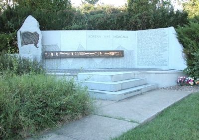
Jefferson County (Kentucky) Korean War Memorial
RANKED BY RELEVANCE
| On McNeely Lake Drive (Park Road) 0.4 miles south of Cooper Chapel Road, on the right when traveling south. |
| On West Jefferson Street near South 5th Street, on the right when traveling west. |
| Near South College Street (U.S. 127) at West Lexington Street, on the right when traveling south. |
| On Main Street (U.S. 60) at 5th Street, on the left when traveling east on Main Street. |
| Near West Jefferson Street at South 6th Street, on the right when traveling east. |
| On S 2nd Street at W Main Street, on the right when traveling north on S 2nd Street. |
| On 1st Street just south of Market. |
| Near South College Street (U.S. 127) at West Lexington Street, on the right when traveling south. |
| On Lincoln Park Road (Kentucky Route 528) south of Fairlane Drive, on the left when traveling south. |
| Near Wilkinson Boulevard (U.S. 421) north of West Plaza Connector Road (U.S. 127), on the right when traveling south. |
| On Shelbyville Road (U.S. 60) at Whipps Mill Road, on the right when traveling west on Shelbyville Road. |
| On Beechland Road (Kentucky Route 438) at Lincoln Park Road ( Route 528), on the left when traveling east on Beechland Road. |
| On W Main Street at N 6th Street, on the right when traveling west on W Main Street. |
| On West Main Street west of South 1st Avenue, on the right when traveling east. |
| Near Baxter Avenue (U.S. 31E/150) at Cherokee Road, on the right when traveling north. |
| On Breckenridge Lane (State Road 1932) at Hillsboro Road, on the right when traveling south on Breckenridge Lane. |
| On Louisville/Bardstown Road (U.S. 31E/150) 0 miles north of Wheeler Wright Lane, on the right when traveling north. |
| On E Andrew Johnson Highway (U.S. 11), on the right when traveling east. |
| On South 2nd Street (Kentucky Route 1020) at West Cardinal Boulevard, on the left when traveling north on South 2nd Street. |
| On South 3rd Street south of West Cardinal Boulevard, on the left when traveling south. |
| On Westport Road (Kentucky Route 524) at 4th Street, on the right when traveling west on Westport Road. |
| Near Farmington Access Rd. east of Lowell Avenue. |
| On Short Street just west of South Main Street, on the left when traveling west. |
| Near Beechland Road (Kentucky Route 438) at Lincoln Park Road ( Route 528), on the left when traveling east. |
| Near Beechland Road (Kentucky Route 438) at Lincoln Park Road ( Route 528), on the left when traveling east. |
| Near Beechland Road (Kentucky Route 438) at Lincoln Park Road ( Route 528), on the left when traveling east. |
| On Rankin Hill Road (County Route 556) 1.5 miles east of North Second Street, on the right when traveling south. |
| On Morgan Jaymes Drive west of Justine Court, on the right when traveling west. |
| On Kanawha Trail (Virginia Route 311) 0.3 miles south of Sweet Springs Lane, on the right when traveling south. |
| On Sweet Springs Valley Road (West Virginia Route 3) at Kanawha Trail ( Route 311), in the median on Sweet Springs Valley Road. |
| On West Main Street (U.S. 31W) just east of South 3rd Street, on the left when traveling west. |
| On Bethesda Road, on the right when traveling north. |
| Near E. Market Street 0.2 miles S. Allen Street. |
| Near Taylorsville Road (State Road 155), on the right when traveling west. |
| On W Jefferson Street at S 5th Street, on the right when traveling west on W Jefferson Street. |
| On Capital Street 0.1 miles south of East 4th Street, on the right when traveling south. |
| Near Martin Luther King Drive at Nueces Street. |
| On Dixie Highway (U.S. 60) at Depot Lane, on the right when traveling north on Dixie Highway. |
| On W Jefferson Street near S 5th Street, on the right when traveling west. |
| On Old Shelbyville Road at Middletown Square, on the left when traveling west on Old Shelbyville Road. |
| On George Street at Washington Street on George Street. |
| On North Broadway at West 3rd Street, on the right when traveling north on North Broadway. |
| Near West River Road at North 4th Street, on the right when traveling west. |
| On Poplar Level Road (State Road 864) 0.1 miles south of Eastern Parkway, on the right when traveling north. |
| Near Bergholz-New Somerset Road 0.2 miles north of State Park-Mooretown Road. |
| Near South Lewis Boulevard 0.3 miles Lincoln Way. |
| Near Old Stage Coach Road 0.1 miles east of Long Run Road, on the right when traveling east. |
| On W Main Street 0.2 miles north of Place Montpellier, on the right when traveling west. |
| On Mallard Creek Road at Sherburn Lane, on the left when traveling north on Mallard Creek Road. |
| On Opal Road NE (County Route 294), on the right when traveling west. |
| On Russell Avenue at Summitt Street, on the right when traveling north on Russell Avenue. |
| Near Timberwood Circle at Florian Road. |
Thin black lines indicate changes in relevance. Between each pair of lines entries are ordered geographically but all have the same relevance.* Inflectional forms of words are their plurals, singulars, and possessives as well as gramatical tenses and similar variations.
Nov. 13, 2026
