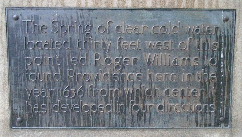
The Spring of clear cold water located thirty feet west of this point led Roger Williams to found Providence here in the year 1636 from which center has developed in four directions — — Map (db m122490) HM
Welcome to the birthplace of religious freedom in the United States. Roger Williams, fleeing religious persecution in England and Massachusetts Bay Colony, founded Providence here in 1636. The original inhabitants, the Narragansett and Wampanoag, . . . — — Map (db m222490) HM
For thousands of years before European settlement, people came from across the region to the Great Salt Cove to hunt, fish, and farm. The Narragansett, Wampanoag, Massachusett, and Nipmuc all used the trails that intersected here on the upper . . . — — Map (db m115212) HM
This building, originally known as St. Francis Xavier Convent of Mercy, was constructed in 1894 on the site of the first convent of the Sisters of Mercy when they came to Providence on March 12, 1851. The Providence congregation was founded by . . . — — Map (db m223075) HM
The Steeple Street Complex was built in three main stages between 1827 and 1847 during a key period in Providence's growth into a leading commercial and industrial city. When Joseph Congdon and Randall Green built the first section, 3 Steeple, to . . . — — Map (db m56171) HM
Stephanie tells me that she was born in Senegal and spoke only French as a child, but Ashley was born in Providence. They say that their family is originally from Cape Verde, an island chain off the coast of West Africa that was uninhabited until . . . — — Map (db m151648) HM
Has Been Designated a National Historic Landmark
this site posses National significance in commemorating the history of the United States of America
An important example of modern monolithic granite construction, this is one of the most . . . — — Map (db m44926) HM
The Changing Face of the West Bank
Unlike the straight waterline of the east bank of the Providence River—formed by the steep, rising hillside—the west bank was irregular and swampy. By 1819, while the entire length of the east . . . — — Map (db m151751) HM
The ship George Washington was the last of three ships all named by John Brown after his friend and compatriot. The 624-ton ship George Washington, designed for the India trade, was built in Providence in 1793 and made its first voyage . . . — — Map (db m151748) HM
This monument erected by
the City of Providence
to her sons who on land and sea defended the nation's honor in the War with Spain, the Insurrection in the Philippines and the China Relief Expedition • 1898 - 1902 — — Map (db m222299) WM
You are standing in the middle of what was not so long ago a major city entrance ramp from Interstate Route 195. Until the year 2002, heavily trafficked highway access roads lines the length of both river banks. Upriver, the granite-clad pedestrian . . . — — Map (db m151747) HM
A Short River Through Time
“Mooshausick,” was the name given by the native Narragansett tribe to the body of water that flows into the Providence River at Confluence Park. It means “river where the moose . . . — — Map (db m107704) HM
Early Years: Providence is a city with a long waterfront tradition. In 1636 Providence was established on the banks of the Providence River. During the 1600's, Providence, initially a farming community, grew slowly, spreading out along the . . . — — Map (db m151744) HM
Left Plaque The Spring on this lot was the original water supply around which Roger Williams gathered the first settlers was in 1721 by reservation in the deed from the Proprietors of Providence made accessible to the townspeople forever . . . — — Map (db m56174) HM
Daniel Chester French
Completed 1902
Restored 2002 by Granoff Associates
Daniel Chester French is best known as the sculptor of the Lincoln Memorial and Concord's Minute Man. This statuary portrays the two cultures that defined New England . . . — — Map (db m56285) HM
Providence completed its third railroad station in 1898 to accommodate the surging growth in passenger and freight service that would continue until World War II. Freight yards stretched from here at Canal Street as far to the west as the eye . . . — — Map (db m223306) HM
A freshwater spring attracted Roger Williams to this site and anchored the community.
Williams built his house across the street, and religious and civil meetings took place around its “gushing” waters.
The spring remained in . . . — — Map (db m107747) HM
The Early Years
“Wanasquatucket” was the name given by the native Narragansett tribe to the larger river that flows into the Providence River and Confluence Park. It means “the river where the tide ends.” This panel, along with the panel . . . — — Map (db m107723) HM
Union Station
has been listed in the
National Register
of Historic Places
by the United States
Department of the Interior
[Additional plaque on the building:]
Union Station
Architects
Stone, Carpenter & . . . — — Map (db m151638) HM
Honor • Courage • Duty • Loyalty • Country • Heroism
In honor of those men and women who so gallantly answered the call to serve their nation in World War II • The Korean Conflict and in the Vietnam Era. We proudly remember their names . . . — — Map (db m223036) WM
This mosaic was created by more than 10,000 Rhode Island Residents of all ages, races, religion, and cultures. The magnificent artwork you see here is a tribute to loved ones lost, to the heroes of the 9-11-01 tragedy and to our hope for the . . . — — Map (db m56474) WM
Development of the Rhode Island House Plan
1636 - 1800
Early 17th century house plan: one and a half story end chimney house frame, typical one room end chimney plan, and framing details. Studs were not often used in early Rhode Island . . . — — Map (db m151710) HM
These rivers were named by the Narragansett & Wampanoag peoples peoples before Roger Williams came to Rhode Island. Woonasquatucket means "The River Where the Tide Ends". Moshassuck means "The River Where the Moose Water" — — Map (db m222695) HM
"This capstone of our City's Capital Center Project captures all of the richness of Providence's history, the resplendence of its present, and the promise of its future. Waterplace Park, situated on the site of the former Cove Basin that was . . . — — Map (db m223309) HM
In remembrance of the strength, courage and determination of William Gilane—who created opportunity and a lasting legacy of integrity through living his core values—may his spirit never be forgotten.
Born in 1842 in County . . . — — Map (db m151750) HM
The World War I monument stood at a spot 127 feet north of this plaque until 1987, when it was dismantled to make way for the relocated river. In 1995 it was reerected in Memorial Park to the south of here.
Consideration was given in the . . . — — Map (db m151711) HM
All Saints'
Memorial Church
has been placed on the
National Register
of
Historic Places
in 1980
by the United States
Department of the Interior — — Map (db m222477) HM
In 1841 and 1842 Rhode Island was in a political upheaval known as the Dorr Rebellion. The upheaval was due to an attempt to establish a written state constitution and to expand the elective franchise. When the state legislature refused to . . . — — Map (db m223058) HM
Rhode Island's first and only national office holder as National Orator and National Historian. Order Sons of Italy in America. Dedicated service to the City of Providence for many years. A grateful city, state and country honor the memory of . . . — — Map (db m223061) HM
In 1793, John Brown and associates built the first bridge to connect India Point with what is now East Providence. A toll bridge was variously called John Brown's Bridge, India Bridge, and finally Washington Bridge, because of a wooden statue of . . . — — Map (db m151685) HM
Providence Harbor walk at Fox Point & India Point
1. Fox Point and Night Boat Era 1822-1932 Firefly challenges the Stagecoach Era
2. Colonial Wharf at South Water Street: 1910-1942
3. Fox Point Hurricanes Barrier 1961-1966 Construction and . . . — — Map (db m75989) HM
Cape Verdean Immigration to Rhode Island
The Cape Verdean community in Fox Point originated from the Cape Verde Islands, a tiny archipelago lying 240 nautical miles off the coast of West Africa. Uninhabited prior to discovery by the Portuguese . . . — — Map (db m75995) HM
Providence Harbor walk at Fox Point & India Point
1. Fox Point and Night Boat Era 1822-1932 Firefly challenges the Stagecoach Era
2. Colonial Wharf at South Water Street: 1910-1942
3. Fox Point Hurricanes Barrier 1961-1966 Construction and . . . — — Map (db m75992) HM
Providence River Bridge: Its Design and Construction
Design: The Providence River Bridge is 1,235 feet long and 164 feet wide. Its arch span is 80 feet high and 400 feet long. This structure is a modern day architectural and engineering . . . — — Map (db m151695) HM
Roger Williams, the founder of Rhode Island, was born in London in 1603. After graduating from Cambridge University in 1627, Williams took holy orders in the church of England. In 1630 he emigrated to the New World and settled in the Massachusetts . . . — — Map (db m57585) HM
Providence Harbor walk at Fox Point & India Point
1. Fox Point and Night Boat Era 1822-1932 Firefly challenges the Stagecoach Era.
2. Colonial Wharf at South Water Street: 1910-1942
3. Fox Point Hurricanes Barrier 1961-1966 Construction and . . . — — Map (db m75988) HM
Tockwotton and the Indiamen
The close of the War of Independence in 1783 found the local economy dominated by maritime trade. Wharves along South Water Street became overcrowded with merchant ships, as depicted in the 1800s scene above. In . . . — — Map (db m151689) HM
Welcome to India Point Park
In 1962, Mary Elizabeth Sharpe wrote of her vision for a park at the head of Narragansett Bay. Her passion for landscape allowed her to see beyond the abused and neglected waterfront. She shared her thoughts in a . . . — — Map (db m75991) HM
West Bank / East BankFox Point / India Point and Watchemoket Square
The Washington Bridge connects the historic neighborhoods of Fox Point/India Point in Providence and Watchemoket Square in East Providence. Since 1793, . . . — — Map (db m222549) HM
148 entries matched your criteria. Entries 101 through 148 are listed above. ⊲ Previous 100