35 entries match your criteria.
Historical Markers and War Memorials in Guysborough County, Nova Scotia
By Steve Stoessel
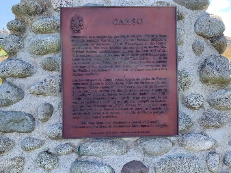
Canso Marker
| 1 ► Nova Scotia, Guysborough County, Canso — Canso — |
| On School Street, on the right when traveling east. | |||
| 2 ► Nova Scotia, Guysborough County, Canso — Canso Soldiers Memorial — |
| On Marine Drive (Nova Scotia Route 16), on the left when traveling east. | |||
| 3 ► Nova Scotia, Guysborough County, Canso — Harbour Traffic/Le traffic du port — |
| Near Water Street. | |||
| 4 ► Nova Scotia, Guysborough County, Canso — In Memory of Tusker 914 En mémoire de — July 13, 2006 — |
| Near Union Street at Queen Street. | |||
| 5 ► Nova Scotia, Guysborough County, Canso — The Canso Islands/ Les îles Canso — |
| Near Water Street. | |||
| 6 ► Nova Scotia, Guysborough County, Canso — We Heard the News First/Nous étions les premiers à avoir les nouvelles — |
| Near Union Street. | |||
| 7 ► Nova Scotia, Guysborough County, Canso — Welcome to Canso Harbour/Bienvenue au Port de Canso — |
| Near Water Street. | |||
| 8 ► Nova Scotia, Guysborough County, Canso — Where Fishermen Meet / Lieu de rencontre des pêcheurs — |
| Near Water Street. | |||
| 9 ► Nova Scotia, Guysborough County, Cole Harbour — #5 Radar Unit R.C.A.F Station — Queensport/Cole Harbour — 1942-1945 — |
| On Marine Drive (Nova Scotia Route 316), on the right when traveling west. | |||
| 10 ► Nova Scotia, Guysborough County, Cole Harbour — We Will Remember/Nous Nous Souviendrons — |
| On Marine Drive (Nova Scotia Route 316), on the right when traveling west. | |||
| 11 ► Nova Scotia, Guysborough County, Guysborough — Guysborough — The Court House — |
| On Church Street (Nova Scotia Route 16) at Queen Street, on the left when traveling north on Church Street. | |||
| 12 ► Nova Scotia, Guysborough County, Guysborough — Henry Marshall Tory — 1864-1947 — |
| On Pleasant Street (Nova Scotia Route 16), on the right when traveling north. | |||
| 13 ► Nova Scotia, Guysborough County, Halfway Cove — The Voyage of Prince Henry Sinclair — The Chronicles of Prince Henry Sinclair’s Voyage to the New World in 1398 — |
| On Marine Drive (Nova Scotia Route 16), on the left when traveling east. | |||
| 14 ► Nova Scotia, Guysborough County, Larrys River — 4 — Acadian Dyke Building Along the Bay of Fundy — Construction de digues le long de la Baie de Fundy — |
| On Marine Drive (Nova Scotia Route 316) at Ballfield Loop, on the right when traveling west on Marine Drive. | |||
| 15 ► Nova Scotia, Guysborough County, Larrys River — 9 — Chezzetcook, Tracadie and Havre Boucher — |
| On Marine Drive (Nova Scotia Route 316) at Ballfield Loop, on the right when traveling west on Marine Drive. | |||
| 16 ► Nova Scotia, Guysborough County, Larrys River — Founding Families of the Acadian Communities Along Tor Bay 1797-1900 — Familles fondatrices Acadiennes dela Région de Tor Baie 1797-1900 — |
| On Marine Drive (Nova Scotia Route 316) at Ballfield Loop, on the right when traveling west on Marine Drive. | |||
| 17 ► Nova Scotia, Guysborough County, Larrys River — 1 — French Expeditions Aimed At Settling North America — Expéditions françaises destinées à s'établir en Amérique du Nord — |
| On Marine Drive (Nova Scotia Route 316) at Ballfield Loop, on the right when traveling west on Marine Drive. | |||
| 18 ► Nova Scotia, Guysborough County, Larrys River — 5 — Grand-Pré — |
| On Marine Drive (Nova Scotia Route 316) at Ballfield Loop, on the right when traveling west on Marine Drive. | |||
| 19 ► Nova Scotia, Guysborough County, Larrys River — Le Parc de nos Ancêtres — The Park of Our Ancestors — |
| On Marine Drive (Nova Scotia Route 316) at Ballfield Loop, on the right when traveling west on Marine Drive. | |||
| 20 ► Nova Scotia, Guysborough County, Larrys River — 3 — Samuel de Champlain Meets Captain Savalette On Shores of Tor Bay — Champlain rencontre le Capitaine Savalette sur les Côtes de Tor Baie — |
| On Marine Drive (Nova Scotia Route 316) at Ballfield Loop, on the right when traveling west on Marine Drive. | |||
| 21 ► Nova Scotia, Guysborough County, Larrys River — 2 — Settlement of l’Acadie 1604/1605 — L’établissement de l’Acadie, 1604/1605 — |
| On Marine Drive (Nova Scotia Route 316) at Ballfield Loop, on the right when traveling west on Marine Drive. | |||
| 22 ► Nova Scotia, Guysborough County, Larrys River — 10 — Settlement of the Tor Bay Area circa 1797 — |
| On Marine Drive (Nova Scotia Route 316) at Ballfield Loop, on the right when traveling west on Marine Drive. | |||
| 23 ► Nova Scotia, Guysborough County, Larrys River — 6 — The Great Upheaval 1755-1763 — Le grand dérangement — |
| On Marine Drive (Nova Scotia Route 316) at Ballfield Loop on Marine Drive. | |||
| 24 ► Nova Scotia, Guysborough County, Larrys River — 8 — The Resettlement — Rétablissement — |
| On Marine Drive (Nova Scotia Route 316) at Ballfield Loop, on the right when traveling west on Marine Drive. | |||
| 25 ► Nova Scotia, Guysborough County, Larrys River — 7 — The Scattering of a People — La dispersion d’un peuple — |
| On Marine Drive (Nova Scotia Route 316) at Ballfield Loop, on the right when traveling west on Marine Drive. | |||
| 26 ► Nova Scotia, Guysborough County, Larrys River — Tor Bay — First Successful Direct Commercial Cable Landing — |
| On Tor Bay Branch Road, on the right when traveling south. | |||
| 27 ► Nova Scotia, Guysborough County, Port Felix — Captain Savalette — |
| On Marine Drive (Nova Scotia Route 316) at Port Felix Loop, on the left when traveling west on Marine Drive. | |||
| 28 ► Nova Scotia, Guysborough County, Port Felix — Welcome to Place Savalette — |
| On Marine Street (Nova Scotia Route 316) at Port Felix Loop, on the left when traveling west on Marine Street. | |||
| 29 ► Nova Scotia, Guysborough County, Queensport — Our Forefathers — |
| On Marine Drive (Nova Scotia Route 16), on the left when traveling east. | |||
| 30 ► Nova Scotia, Guysborough County, Queensport — Queensport, Guysborough County — |
| On Marine Drive (Nova Scotia Route 16), on the left when traveling east. | |||
| 31 ► Nova Scotia, Guysborough County, Whitehead — Folklore & Trivia — |
| Near Whitehead Road, on the right when traveling south. | |||
| 32 ► Nova Scotia, Guysborough County, Whitehead — Port Felix — |
| Near Whitehead Road, on the right when traveling south. | |||
| 33 ► Nova Scotia, Guysborough County, Whitehead — The Canal — |
| On Whitehead Road, on the left when traveling south. | |||
| 34 ► Nova Scotia, Guysborough County, Whitehead — Whitehead — |
| On Whitehead Road, on the left when traveling south. | |||
| 35 ► Nova Scotia, Guysborough County, Whitehead — Yankee Cove — |
| On Whitehead Road, on the left when traveling south. | |||