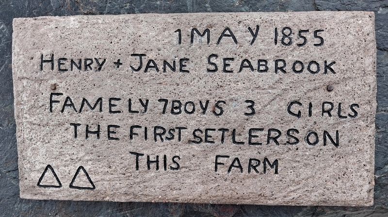
As one of many early pioneers to this area, the Seabrook family
immigrated from the Ferns area of the County Wexford, Ireland.
They arrvived in Ontario in the mid-1800s, settling on Lot 5,
Concession 6, in what was then Belmont Township - 5km . . . — — Map (db m315296) HM
In Celebration of the Village of Havelock's 125th Anniversary
and Canada's 150th Anniversary and also to signify the
amalgamation of the former Belmont Methuen Township and the
Village of Havelock to form the Township of . . . — — Map (db m315299) HM
[southeast]Through sacrifice they gave their today for our tomorrow Our Honoured Dead 1939-1945Howard D. Chamberlain • Eric Innes • Ainslee M. McNeely • Frederick Innes • Herbert Osborne • Arnold Starke • Elmer Stevenson • . . . — — Map (db m315451) WM
The West Riding Peterborough Agricultural Society Fair had been searching for many years for a larger location to hold the fair, and the closure of the Burial Grounds provided a perfect opportunity for much needed open space. The “Agricultural . . . — — Map (db m260799) HM
A tribute to the Canadian volunteers and to the memory of Capt. Edward T. Brown, of Boulton’s Scouts, a native of this county who fell at Batoche on May 12th, 1885 — — Map (db m260797) HM
The transformation of the agricultural fair site and old burial grounds into a formal park was important to the citizens of Peterborough who protested the Town Council's first plan to subdivide the area into building lots. In 1884 Council agreed . . . — — Map (db m260796) HM
[English] D-Day and the Battle of Normandy 6 June-21 August 1944 After months of elaborate planning, the largest seaborne invasion in modern history commenced on 6 June 1944 (D-Day) to liberate northwestern . . . — — Map (db m260998) HM
Central Park was an ideal site for a military training area with its expansive grounds and location — accessible by foot, horse and wagon. A drill shed was built in 1867 and used for band practices, dances and military activities. Drill sheds were . . . — — Map (db m260795) HM
Peterborough's first burial ground was laid out in 1825 on the land bounded by Aylmer, George, Murray and McDonnel Streets. At the time, this was the northern edge of the town. It was multidenominational with areas for Roman Catholics, Anglicans, . . . — — Map (db m260918) HM
Louis Riel 1844-1885 [English] Louis Riel led the Red River Métis in opposing Canadian expansion into their region in 1869. Only 25 years old at the time, Riel was chosen to head the provisional . . . — — Map (db m260999) HM
Sandford Fleming arrived at this house from Scotland on June 7, 1845. He resided here with his cousin, Dr. John Hutchison, for nearly two years. During this time he surveyed and made a map of the townsite of Peterborough. Here he met his future . . . — — Map (db m260698) HM
An outstanding example of Greek revival architecture, modified in the Palladian manner, it was begun about 1847 by P.M. Grover, a well-to-do local merchant. A type of building rare in Ontario, it was probably inspired by a "design for a villa" . . . — — Map (db m260694) HM
Here on December 6, 1960, the skeletal remains of a man who lived in this area about 2,000 years ago were discovered by Douglas Yaxley of Peterborough. Buried with the man were twenty-nine artifacts attributed to the Point Peninsula Culture, which . . . — — Map (db m260778) HM
[English] The parish of St. Peter-in-Chains was established in 1826 to serve the large Irish Catholic population of the surrounding Robinson Settlement. This building, erected in 1837-38 of stone from nearby . . . — — Map (db m260697) HM
This stone house, completed by February 1837, was first occupied by Dr. John Hutchison, Peterborough's first permanently established physician. A native of Kirkcaldy, Scotland, Hutchison had come to Upper Canada by 1818 and practiced in the Rice . . . — — Map (db m260696) HM
Riding a wave of national pride and military enthusiasm following the South African War (1899-1902), the Canadian government embarked on a major reform of the nation's defence system. The new programme included an expanded and upgraded . . . — — Map (db m260700) HM
[English] Opened in 1904, with a lift of 19.8 metres, this is the highest hydraulic lift lock in the world and the first of two built in North America, both on the Trent-Severn Waterway. It operates on a balance principle. A . . . — — Map (db m247847) HM
The old Post Office, located at the north-west corner of Hunter and Water Streets, opened in 1888 and was demolished in 1955 soon after the new Post Office on Charlotte St. was opened. The building was designed in Ottawa by Dominion architect . . . — — Map (db m260785) HM
The Tollington Bridge was constructed in 1998 to access the Rotary Greenway Trail along the north shore of Little Lake. Funds for this project were provided by the Tollington Park Endowment Fund. Impressed by the beauty of the parks and the . . . — — Map (db m260981) HM
• The Peterborough Lift Lock was inaugurated on July 9, 1904. It took eight years to build. • With a height of 19.8 metres, it is the highest hydraulic lift . . . — — Map (db m260800) HM
[English] Women in Canada and Newfoundland significantly contributed to Allied victory. Whereas women were military nurses during the First World War, more than 50,000 were now serving in uniform as non-combatants in . . . — — Map (db m260987) HM