[West Historic Marker]:Amherstburg Navy Yard
A Navy Yard was built here in 1796 to replace Detroit as the base and supply depot for the Provincial Marine on Lakes Erie and Huron. In 1812 the GENERAL HUNTER and QUEEN CHARLOTTE, built . . . — — Map (db m37552) HM
This house, one of the finest remaining examples of domestic Georgian architecture in Ontario, was commenced in 1816 and completed about 1819, by Robert Reynolds, the commissary to the garrison at Fort Malden. Bellevue was also the home of his . . . — — Map (db m103677) HM
Boblo Island
For many centuries the island you see in front of you was used for hunting and fishing by First Nations people. Called Île aux Bois Blancs by the French, Boblo Island's key location made it a site for . . . — — Map (db m71185) HM
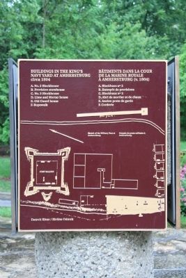
Brick Officers' Guard Room
and Staff Sergeant's Quarters
(1839)
Poste de garde des officiers en
briques et quartiers du sergent
de l'etat-major (1839) — — Map (db m71220) HM
On January 9, 1838, a force of Canadians and Americans sympathizing with Mackenzie's rebellion, sailed from United States territory and landed on Bois Blane Island. The schooner "Anne," supporting the invasion, cruised along the Canadian mainland . . . — — Map (db m37246) HM
Near this site stood the house erected in 1784 by Matthew Elliott. Born in Ireland, he emigrated to the American Colonies in 1761, and during the Revolution served with the British forces as a captain in the Indian Department. He was an Indian agent . . . — — Map (db m37286) HM
Connection to Town
Fort Malden (originally called Fort Amherstburg) was the anchor of the town, which grew to the south. In this view, you are looking past the parade grounds of the fort (now a park) down Dalhousie Street . . . — — Map (db m71192) HM
Detroit River Heritage
This river not only forms the border between two great nations, but is also a vital transportation artery into the upper Great Lakes. Imagine the vessels that have travelled on it … First National canoes, . . . — — Map (db m71160) HM
The post was begun by the Royal Canadian Volunteers in 1796 to replace Detroit and to maintain British influence among the western Indians. As the principal defense of the Detroit frontier in 1812, it was here that Isaac Brock gathered his forces . . . — — Map (db m34353) HM
Fort Defences
In front of you is a recreated piece of the fort's palisade, a vertical wall of sharpened logs. This wall surrounded the fort, linking the four diamond-shaped corner projections, called bastions. Around each . . . — — Map (db m71173) HM
Fort Malden Points of Interest • Fort Malden Points d'intérêt
(1) Visitor Centre
1939
Centre d'accueil
1939
(2) Military Pensioner's Cottage
circa 1851 (Restoration) . . . — — Map (db m71278) HM
Indian Council House
Two hundred years ago a small building stood about 100 metres north of here, close to the water's edge. This was where meetings took place between the representatives of the British government and those of . . . — — Map (db m71170) HM
Born about 1750 in Fermanagh County, Ireland, Caldwell emigrated to Pennsylvania in 1773. During the American Revolution he served with the British forces as a captain in Butler's Rangers at Niagara and Detroit. In 1784 he obtained land near the . . . — — Map (db m37291) HM
Born at Queenston in Upper Canada, John Richardson served as a volunteer at Fort Malden during the War of 1812 and was taken prisoner by the Americans at Moraviantown. He was released at war's end, retired on half-pay in 1818, and spent most of the . . . — — Map (db m76737) HM
Pensioner's Cottage
This cottage was built in the early 1850s for a retired soldier and his family. About 85 of these homes were constructed just east of the Fort, and leased at a modest rate to veteran soldiers in return for light . . . — — Map (db m71167) HM
Privy
The foundations in front of you are from a communal privy (toilet) for enlisted men and their families that stood here in 1840. The women and children had a small room - the soldiers made do with an open structure offering . . . — — Map (db m71221) HM
Shoreline Breakwall
Over time, the force of water and ice has eroded the river bank, creating the need to stabilize the shore. Parks Canada, the Essex Region Conservation Authority (ERCA) and Environment Canada partnered to . . . — — Map (db m71161) HM
Girty's life crossed cultural boundaries between native and white societies on the frontier of American settlement. In 1756 his family was captured by a French-led native war party in Pennsylvania. Simon was adopted by the Seneca, then repatriated . . . — — Map (db m34688) HM
In the War of 1812, the first engagement in Canada involving British and American forces in significant numbers occurred here on the Canard River. On July 12, 1812, Brigadier-General William Hull invaded Canada and encamped near Sandwich. British . . . — — Map (db m34336) HM
Strategic Location
A deepwater channel between here and Boblo Island brings ships close to shore, a fact dramatically illustrated when a north-bound lake freighter passes by. This was why Fort Amerstburg was originally located . . . — — Map (db m71191) HM
Tradition has it that the Indian leader Tecumseh stood upon this stone to deliver a final address to the British at Amherstburg after the Battle of Lake Erie. Donated in 1939, it originally stood near the corner of Dalhousie and Gore Streets. In his . . . — — Map (db m34412) HM
In September 1813 the British squadron under R. Barclay sailed from Amherstburg to collect desperately needed food supplies. They were met by the larger, more heavily armed American squadron commanded by O. Perry. The British had the initial . . . — — Map (db m37707) HM
The office for the Commissariat Department was built in 1831 near the government wharf and storehouse. Commissary officials purchased from local contractors the flour, beef, straw and firewood used by troops. They also managed Fort Malden's . . . — — Map (db m37356) HM
Part of an ancient network of Indian paths, the Great Sauk Trail, as it came to be known, extended from Rock Island in present-day Illinois to the Detroit River. It played a significant role in the communications between the native peoples in the . . . — — Map (db m36976) HM
The Site Over Time
Today the site looks very different than it would have 170 years ago, when Fort Malden was at its height. Almost all the buildings from that period have been lost, and most of the ditch and wall that encircled . . . — — Map (db m71174) HM
This area was once the home of the Wyandot, remnants of the Huron, Neutrals, and Petuns who were dispersed by the Iroquois in the 1640's. Some eventually reunited and settled along the Detroit River, where they became known as the Hurons of Detroit, . . . — — Map (db m37340) HM