By Dale K. Benington, August 9, 2010
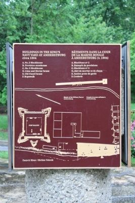
Buildings in the King's Navy Yard at Amherstburg Marker
| Near Dalhousie Street west of Rankin Avenue. |
| On Dalhousie Street, on the left when traveling south. |
| Near Laird Avenue South just south of Elm Avenue, on the right when traveling south. |
| Near Laird Avenue South just south of Elm Avenue, on the right when traveling south. |
| On Front Road South (County Route 20) south of Dalhousie Street, on the left when traveling south. |
| On Front Road South (County Route 20) close to Dalhousie Street, on the left when traveling south. |
| Near Laird Avenue South just south of Elm Avenue, on the right when traveling south. |
| Near Laird Avenue South just south of Elm Avenue, on the right when traveling south. |
| On Laird Avenue South south of Elm Avenue, on the right when traveling south. |
| Near Laird Avenue South just south of Elm Avenue, on the right when traveling south. |
| Near Laird Avenue South just south of Elm Avenue, on the right when traveling south. |
| Near Laird Avenue South just south of Elm Avenue, on the right when traveling south. |
| On Ramsay Street south of Gore Street, on the left when traveling south. |
| Near Laird Avenue South close to Elm Avenue, on the right when traveling south. |
| Near Laird Avenue South just south of Elm Avenue, on the right when traveling south. |
| Near Laird Avenue South just south of Elm Avenue, on the right when traveling south. |
| Near Laird Avenue South just south of Elm Avenue, on the right when traveling south. |
| On Front Street South (Provincial Highway 20) south of Bingham Road, on the left when traveling south. |
| On Front Street North (Provincial Highway 20) north of North Side Road, on the right when traveling south. |
| Near Laird Avenue South just south of Elm Avenue, on the right when traveling south. |
| On Laird Avenue South south of Elm Avenue, on the right when traveling south. |
| Near Dalhousie Street west of Rankin Avenue. |
| Near Dalhousie Street west of Rankin Avenue. |
| On Dalhousie Street north of Richmond Street, on the right when traveling south. |
| Near Laird Avenue South just south of Elm Avenue, on the right when traveling south. |
| On Front Road North north of County Route 10, on the right when traveling south. |